File:Anatolia1200.png
Jump to navigation
Jump to search
No higher resolution available.
Anatolia1200.png (642 × 430 pixels, file size: 86 KB, MIME type: image/png)
Captions
Captions
Add a one-line explanation of what this file represents

|
This historical map image could be re-created using vector graphics as an SVG file. This has several advantages; see Commons:Media for cleanup for more information. If an SVG form of this image is available, please upload it and afterwards replace this template with
{{vector version available|new image name}}.
It is recommended to name the SVG file “Anatolia1200.svg”—then the template Vector version available (or Vva) does not need the new image name parameter. |
Summary[edit]
| Description |
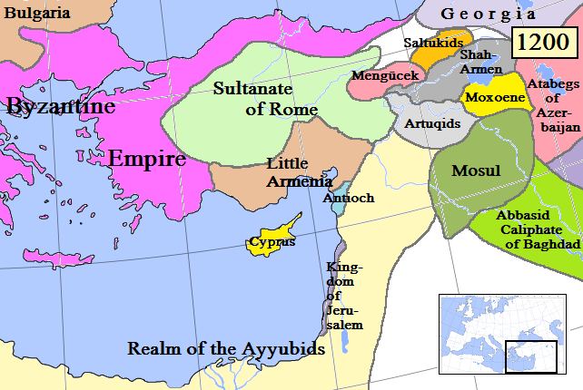
English: Map of Anatolia and some surrounding regions in AD 1200.
(Partially based on Euratlas map of Europe, 1200.) |
| Date | |
| Source | Own work |
| Author | Gabagool |
| Other versions |
Derivative works of this file: Kingdom of Cilicia-Anatolia1200-Masry.jpg |
Licensing[edit]
I, the copyright holder of this work, hereby publish it under the following license:
This file is licensed under the Creative Commons Attribution 3.0 Unported license.
- You are free:
- to share – to copy, distribute and transmit the work
- to remix – to adapt the work
- Under the following conditions:
- attribution – You must give appropriate credit, provide a link to the license, and indicate if changes were made. You may do so in any reasonable manner, but not in any way that suggests the licensor endorses you or your use.
File history
Click on a date/time to view the file as it appeared at that time.
| Date/Time | Thumbnail | Dimensions | User | Comment | |
|---|---|---|---|---|---|
| current | 15:55, 19 April 2009 | | 642 × 430 (86 KB) | Gabagool (talk | contribs) | Added more names to states. Cyprus now yellow to match other maps better. |
| 22:37, 17 April 2009 |  | 642 × 430 (84 KB) | Gabagool (talk | contribs) | Extended Shah-Armen area per [http://en.wikipedia.org/wiki/Sassoun] ("The region was later ruled by the Mamikonian dynasty from around 772 until 1189/1190, when the Mamikonians moved to Cilicia after being dispossessed by Shah-Armen.") New Armenia -> Litt | |
| 23:54, 2 April 2009 |  | 642 × 430 (84 KB) | Gabagool (talk | contribs) | {{Information |Description={{en|1=Map of Anatolia and some surrounding regions in AD 1200. (Partially based on Euratlas map of Europe, 1200.)}} |Source=Own work by uploader |Author=Gabagool |Date=2009-04-03 |Permission= |other_versions= |
You cannot overwrite this file.
File usage on Commons
The following 5 pages use this file:
File usage on other wikis
The following other wikis use this file:
- Usage on ar.wikipedia.org
- Usage on ast.wikipedia.org
- Usage on azb.wikipedia.org
- Usage on az.wikipedia.org
- Usage on be.wikipedia.org
- Usage on de.wikipedia.org
- Usage on el.wikipedia.org
- Usage on en.wikipedia.org
- Usage on eo.wikipedia.org
- Usage on es.wikipedia.org
- Usage on et.wikipedia.org
- Usage on fa.wikipedia.org
- Usage on fr.wikipedia.org
- Usage on gl.wikipedia.org
- Usage on hy.wikipedia.org
- Usage on hyw.wikipedia.org
- Usage on it.wikipedia.org
- Usage on ja.wikipedia.org
- Usage on ka.wikipedia.org
- Usage on kk.wikipedia.org
- Usage on ko.wikipedia.org
- Usage on lt.wikipedia.org
- Usage on ml.wikipedia.org
- Usage on nl.wikipedia.org
- Usage on no.wikipedia.org
- Usage on pnb.wikipedia.org
- Usage on pt.wikipedia.org
- Usage on ro.wikipedia.org
- Usage on ru.wikipedia.org
View more global usage of this file.