File:Amsterdam 1560 b.jpg
Jump to navigation
Jump to search

Size of this preview: 491 × 599 pixels. Other resolutions: 196 × 240 pixels | 393 × 480 pixels | 629 × 768 pixels | 839 × 1,024 pixels | 1,677 × 2,048 pixels | 4,283 × 5,229 pixels.
Original file (4,283 × 5,229 pixels, file size: 3.25 MB, MIME type: image/jpeg)
Captions
Captions
Add a one-line explanation of what this file represents
Summary
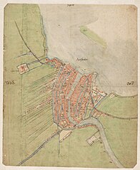
[edit]| Jacob van Deventer: Map of Amsterdam
|
|||||||||||||||||||||||||
|---|---|---|---|---|---|---|---|---|---|---|---|---|---|---|---|---|---|---|---|---|---|---|---|---|---|
| Artist |
|
 | |||||||||||||||||||||||
| Title |
Map of Amsterdam and Environs |
||||||||||||||||||||||||
| Object type |
floor plan / map / city map |
||||||||||||||||||||||||
| Description |
Plattegrond van Amsterdam en omgeving. Eerste plattegrond van Amsterdam in de ware zin van het woord. Gemaakt in opdracht van Filips II van Spanje. De oriëntatie op het noorden werd pas in de 19e eeuw weer op Amsterdamse plattegronden worden toegepast. |
||||||||||||||||||||||||
| Date | between 1550 and 1570 | ||||||||||||||||||||||||
| Medium | pen, brush and color | ||||||||||||||||||||||||
| Dimensions | height: 43 cm (16.9 in); width: 35 cm (13.7 in) | ||||||||||||||||||||||||
| Collection |
|
||||||||||||||||||||||||
| Current location |
Provinciale Atlas - Kaarten en kaartboeken |
||||||||||||||||||||||||
| Accession number |
A(492.629.005)073 |
||||||||||||||||||||||||
| Place of creation | Northern Netherlands | ||||||||||||||||||||||||
| Object history | Het Aanzien van Amsterdam. Panorama's, plattegronden en profielen uit de Gouden Eeuw, Stadsarchief Amsterdam, Amsterdam, 19 October 2007–16 January 2008, ISBN 978-90-6868-444-5, p. 92-95, cat. no. 5, as Map of Amsterdam and environs, 1558-1561. | ||||||||||||||||||||||||
| Exhibition history | Unknown | ||||||||||||||||||||||||
| Inscriptions |
top center: Noordt
center left: West
center right: Oost
center: Aemſterdam
|
||||||||||||||||||||||||
| References | Noord-Hollands Archief, as Kaart van Amsterdam en omgeving, circa 1560. | ||||||||||||||||||||||||
| Source/Photographer | www.beeldbank.noord-hollandsarchief.nl : Home : Info | ||||||||||||||||||||||||
| Other versions |
|
||||||||||||||||||||||||


,_Afb_KOKA00024000001.jpg)
Licensing
[edit]
|
This is a faithful photographic reproduction of a two-dimensional, public domain work of art. The work of art itself is in the public domain for the following reason:
The official position taken by the Wikimedia Foundation is that "faithful reproductions of two-dimensional public domain works of art are public domain".
This photographic reproduction is therefore also considered to be in the public domain in the United States. In other jurisdictions, re-use of this content may be restricted; see Reuse of PD-Art photographs for details. | ||||
File history
Click on a date/time to view the file as it appeared at that time.
| Date/Time | Thumbnail | Dimensions | User | Comment | |
|---|---|---|---|---|---|
| current | 22:58, 17 March 2016 | | 4,283 × 5,229 (3.25 MB) | Hannolans (talk | contribs) | higher resolution |
| 18:14, 9 December 2014 |  | 2,082 × 2,535 (2.02 MB) | Vincent Steenberg (talk | contribs) | full image | |
| 16:05, 29 June 2010 |  | 1,904 × 1,885 (4.91 MB) | Joopr (talk | contribs) | {{Information |Description={{nl|1=Plattegrond van Amsterdam}} |Source=Eigen verzameling |Author=Jacob van Deventer |Date=1550 |Permission= |other_versions= }} Category:Plattegrond Category:Amsterdam Category:Cartografie [[Category:Cartography |
You cannot overwrite this file.
File usage on Commons
The following 4 pages use this file:
File usage on other wikis
The following other wikis use this file:
- Usage on fr.wikipedia.org
- Usage on it.wikipedia.org
- Usage on nl.wikipedia.org
- Usage on www.wikidata.org