File:Amman, Jordan with location of Al-Wehdat camp.png
Jump to navigation
Jump to search

Size of this preview: 800 × 519 pixels. Other resolutions: 320 × 208 pixels | 640 × 415 pixels | 1,104 × 716 pixels.
Original file (1,104 × 716 pixels, file size: 586 KB, MIME type: image/png)
Captions
Captions
Add a one-line explanation of what this file represents
Summary[edit]
| Description |
English: http://www.openstreetmap.org/ |
| Date | |
| Source | Own work |
| Author | Oceanflynn |
| Camera location | | View this and other nearby images on: OpenStreetMap |
|---|
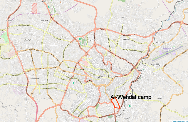
The map of Ammam uploaded by Makeandtoss is from http://www.openstreetmap.org. I outlined the camp boundaries: 50 miles along Prince Al-Hassan Street, .24 miles along Al Aaydeen Street, .32 miles along Usama Ben Zayd Street, .77 miles along Sumayya Street. based on http://wikimapia.org 31.930330, 35.938725 highlight of camp shape.
Licensing[edit]
I, the copyright holder of this work, hereby publish it under the following license:
| This file is made available under the Creative Commons CC0 1.0 Universal Public Domain Dedication. | |
| The person who associated a work with this deed has dedicated the work to the public domain by waiving all of their rights to the work worldwide under copyright law, including all related and neighboring rights, to the extent allowed by law. You can copy, modify, distribute and perform the work, even for commercial purposes, all without asking permission.
|
File history
Click on a date/time to view the file as it appeared at that time.
| Date/Time | Thumbnail | Dimensions | User | Comment | |
|---|---|---|---|---|---|
| current | 20:41, 27 January 2018 | | 1,104 × 716 (586 KB) | Oceanflynn (talk | contribs) | User created page with UploadWizard |
You cannot overwrite this file.
File usage on Commons
There are no pages that use this file.
File usage on other wikis
The following other wikis use this file:
- Usage on ar.wikipedia.org
- Usage on ca.wikipedia.org
- Usage on en.wikipedia.org
- Usage on es.wikipedia.org
- Usage on fa.wikipedia.org
- Usage on fr.wikipedia.org
- Usage on www.wikidata.org