File:Allon Plan.svg
Jump to navigation
Jump to search

Size of this PNG preview of this SVG file: 417 × 599 pixels. Other resolutions: 167 × 240 pixels | 334 × 480 pixels | 535 × 768 pixels | 713 × 1,024 pixels | 1,426 × 2,048 pixels | 732 × 1,051 pixels.
Original file (SVG file, nominally 732 × 1,051 pixels, file size: 209 KB)
Captions
Captions
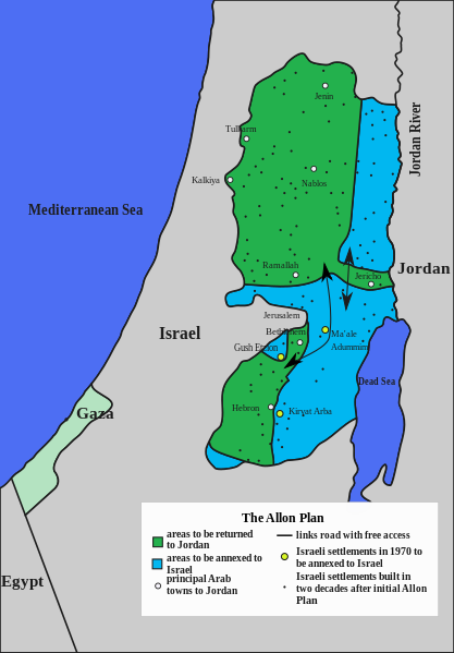
Allon Plan
Summary[edit]
| Description |
English: The Allon Plan was a plan to partition the West Bank between Israel and the Hashemite Kingdom of Jordan, create a Druze state in the Israeli-occupied Golan Heights, and return most of the Sinai Peninsula to Arab control. The plan was drafted by Israeli Minister Yigal Allon shortly after the Six-Day War in June 1967. |
| Date | |
| Source | File:Allon.jpg |
| Author | Pato Burgues |
Licensing[edit]
I, the copyright holder of this work, hereby publish it under the following license:
This file is licensed under the Creative Commons Attribution-Share Alike 4.0 International license.
- You are free:
- to share – to copy, distribute and transmit the work
- to remix – to adapt the work
- Under the following conditions:
- attribution – You must give appropriate credit, provide a link to the license, and indicate if changes were made. You may do so in any reasonable manner, but not in any way that suggests the licensor endorses you or your use.
- share alike – If you remix, transform, or build upon the material, you must distribute your contributions under the same or compatible license as the original.
File history
Click on a date/time to view the file as it appeared at that time.
| Date/Time | Thumbnail | Dimensions | User | Comment | |
|---|---|---|---|---|---|
| current | 11:48, 23 November 2022 | | 732 × 1,051 (209 KB) | MS Sakib (talk | contribs) | Alignment |
| 11:47, 23 November 2022 |  | 732 × 1,051 (209 KB) | MS Sakib (talk | contribs) | fixed | |
| 11:53, 5 April 2021 |  | 732 × 1,051 (209 KB) | Pato Burgues (talk | contribs) | actually fixed | |
| 11:52, 5 April 2021 |  | 732 × 1,051 (209 KB) | Pato Burgues (talk | contribs) | fixed map | |
| 11:48, 5 April 2021 |  | 732 × 1,051 (203 KB) | Pato Burgues (talk | contribs) | Uploaded own work with UploadWizard |
You cannot overwrite this file.
File usage on Commons
The following 5 pages use this file:
File usage on other wikis
The following other wikis use this file:
- Usage on ar.wikipedia.org
- Usage on ca.wikipedia.org
- Usage on cs.wikipedia.org
- Usage on cy.wikipedia.org
- Usage on de.wikipedia.org
- Usage on el.wikipedia.org
- Usage on en.wikipedia.org
- Usage on eo.wikipedia.org
- Usage on es.wikipedia.org
- Usage on fa.wikipedia.org
- Usage on fr.wikipedia.org
- Usage on hy.wikipedia.org
- Usage on ja.wikipedia.org
- Usage on pl.wikipedia.org
- Usage on pt.wikipedia.org
- Usage on ru.wikipedia.org
- Usage on sk.wikipedia.org
- Usage on tr.wikipedia.org
- Usage on www.wikidata.org