File:Aldietsterritorium.png
Jump to navigation
Jump to search

Size of this preview: 800 × 600 pixels. Other resolutions: 320 × 240 pixels | 640 × 480 pixels | 1,024 × 768 pixels | 1,280 × 960 pixels | 1,600 × 1,200 pixels.
Original file (1,600 × 1,200 pixels, file size: 723 KB, MIME type: image/png)
Captions
Captions
Add a one-line explanation of what this file represents
| Description |
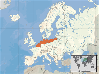
Nederlands: Het Aldietse territorium. |
| Date | |
| Source | HeelNederlandinEuropa.png+ |
| Author | Stuntelaar |
| Permission (Reusing this file) |
This file is licensed under the Creative Commons Attribution-Share Alike 4.0 International license. Attribution: David Liuzzo
|
File history
Click on a date/time to view the file as it appeared at that time.
| Date/Time | Thumbnail | Dimensions | User | Comment | |
|---|---|---|---|---|---|
| current | 10:04, 1 April 2008 | | 1,600 × 1,200 (723 KB) | Stuntelaar~commonswiki (talk | contribs) | {{Information |Description=Het Aldietse territorium. |Source= |Date=01-04-2007 |Author=Stuntelaar |Permission={{EU location}} |other_versions= }} |
You cannot overwrite this file.
File usage on Commons
There are no pages that use this file.
File usage on other wikis
The following other wikis use this file:
- Usage on en.wikipedia.org
- Usage on nl.wikipedia.org
- Usage on ru.wikipedia.org