File:Air Tanzania Destination Map.png
Jump to navigation
Jump to search

Size of this preview: 651 × 599 pixels. Other resolutions: 261 × 240 pixels | 522 × 480 pixels | 834 × 768 pixels | 1,206 × 1,110 pixels.
Original file (1,206 × 1,110 pixels, file size: 268 KB, MIME type: image/png)
Captions
Captions
Add a one-line explanation of what this file represents
Summary[edit]
| Description |
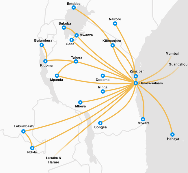
English: Destinations of Air Tanzania as of February 2023 |
| Date | |
| Source | Own work |
| Author | Sputink |
Licensing[edit]
I, the copyright holder of this work, hereby publish it under the following license:
This file is licensed under the Creative Commons Attribution-Share Alike 4.0 International license.
- You are free:
- to share – to copy, distribute and transmit the work
- to remix – to adapt the work
- Under the following conditions:
- attribution – You must give appropriate credit, provide a link to the license, and indicate if changes were made. You may do so in any reasonable manner, but not in any way that suggests the licensor endorses you or your use.
- share alike – If you remix, transform, or build upon the material, you must distribute your contributions under the same or compatible license as the original.
File history
Click on a date/time to view the file as it appeared at that time.
| Date/Time | Thumbnail | Dimensions | User | Comment | |
|---|---|---|---|---|---|
| current | 19:31, 26 February 2023 | | 1,206 × 1,110 (268 KB) | Sputink (talk | contribs) | Added China |
| 00:09, 25 November 2021 |  | 1,206 × 1,110 (3.84 MB) | Sputink (talk | contribs) | November 2021 Destinations | |
| 02:40, 25 December 2019 |  | 1,000 × 1,000 (184 KB) | Sputink (talk | contribs) | Updated destinations to include December 2019 | |
| 01:26, 28 August 2018 |  | 1,000 × 1,000 (175 KB) | Sputink (talk | contribs) | Updates to destinations. August 2018 | |
| 20:34, 10 June 2017 |  | 1,000 × 1,000 (159 KB) | Sputink (talk | contribs) | User created page with UploadWizard |
You cannot overwrite this file.
File usage on Commons
The following 5 pages use this file:
- User:Chumwa/OgreBot/Transport Maps/2023 February 19-28
- User:Chumwa/OgreBot/Travel and communication maps/2023 February 19-28
- Commons:WikiProject Aviation/recent uploads/2017 June 10
- Commons:WikiProject Aviation/recent uploads/2018 August 28
- Commons:WikiProject Aviation/recent uploads/2019 December 25
File usage on other wikis
The following other wikis use this file:
- Usage on af.wikipedia.org
- Usage on el.wikipedia.org
- Usage on en.wikipedia.org
- Usage on eo.wikipedia.org
- Usage on ru.wikipedia.org