File:African phylogenetic structure projected on a map.png
Jump to navigation
Jump to search

Size of this preview: 690 × 600 pixels. Other resolutions: 276 × 240 pixels | 552 × 480 pixels | 883 × 768 pixels | 1,178 × 1,024 pixels | 2,355 × 2,048 pixels | 2,881 × 2,505 pixels.
Original file (2,881 × 2,505 pixels, file size: 14.93 MB, MIME type: image/png)
Captions
Captions
African phylogenetic structure projected on a map
Summary[edit]
| Description |
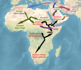
English: African phylogenetic structure projected on a map:
This map displays broadly the phylogenetic structure of Africa after the dispersal of anatomical modern humans (AMH). The first and deepest split (c. 200kya) is associated with the Central and Southern African hunter-gatherers (Mbuti and Khoisan groups etc.), which are occasionally also referred to as "Paleo-Africans". The next split (c. 90kya) was between the ancestors of ancient East and Western Africans and the ancestors of Eurasians. The ancestors of Eurasians migrated Out of Africa (c. 70kya) and remained in a "population hub" in which they underwent geneflow from archaic humans, and from which they expanded in a repetitive pattern, giving rise to Eastern Eurasians (IUP) and Western Eurasians (UP). A remaining group, which shares the same bottleneck events and drift, but did not receive archaic admixture, is known as "Basal Eurasians". In Africa, the "Ancient East Africans" gave rise to "Eastern African hunter-gatherers" (EAHG), the ancestors of West African Niger-Congo speakers, and the ancestors of Nilo-Saharan speakers. The time of divergence of the EAHG is estimated to c. 50kya, while the time of divergence between Ancestral Niger-Congo and Ancestral Nilo-Saharan speakers is estimated to c. 28kya. The Paleolithic population of Northern Africa (represented by the Taforalt specimen) is modeled to have formed from an "Ancient North African" component diverging from the population which would become ancestral to Eurasians (alternatively from a "Sub-Saharan African" component deeply related to the ancestors of West and East Africans), and from a non-African component associated with early Western Eurasians and which arrived through a back migration towards Northern Africa. |
| Date | |
| Source | Own work; map taken from https://commons.wikimedia.org/wiki/File:World_map_geographical.jpg. Based on:[1], [2], [3], [4], [5], [6], [7], [8], [Whole-genome sequencing reveals a complex African population demographic history and signatures of local adaptation], [9]. |
| Author | Wikiuser1314 |
Licensing[edit]
I, the copyright holder of this work, hereby publish it under the following license:
This file is licensed under the Creative Commons Attribution-Share Alike 4.0 International license.
- You are free:
- to share – to copy, distribute and transmit the work
- to remix – to adapt the work
- Under the following conditions:
- attribution – You must give appropriate credit, provide a link to the license, and indicate if changes were made. You may do so in any reasonable manner, but not in any way that suggests the licensor endorses you or your use.
- share alike – If you remix, transform, or build upon the material, you must distribute your contributions under the same or compatible license as the original.
File history
Click on a date/time to view the file as it appeared at that time.
| Date/Time | Thumbnail | Dimensions | User | Comment | |
|---|---|---|---|---|---|
| current | 06:57, 2 October 2023 | | 2,881 × 2,505 (14.93 MB) | Wikiuser1314 (talk | contribs) | Reverted to version as of 08:41, 25 July 2023 (UTC) |
| 14:44, 8 September 2023 |  | 2,881 × 2,505 (14.94 MB) | Wikiuser1314 (talk | contribs) | correction on diverging pattern | |
| 08:41, 25 July 2023 |  | 2,881 × 2,505 (14.93 MB) | Wikiuser1314 (talk | contribs) | Uploaded own work with UploadWizard |
You cannot overwrite this file.
File usage on Commons
The following page uses this file: