File:Aerial view of the Pettiwick Glacier, Greenland, 1952 (22059305225).jpg
Jump to navigation
Jump to search

Size of this preview: 777 × 599 pixels. Other resolutions: 311 × 240 pixels | 622 × 480 pixels | 996 × 768 pixels | 1,280 × 988 pixels | 2,140 × 1,651 pixels.
Original file (2,140 × 1,651 pixels, file size: 1.71 MB, MIME type: image/jpeg)
Captions
Captions
Add a one-line explanation of what this file represents
Summary[edit]
.jpg&action=edit§ion=1)
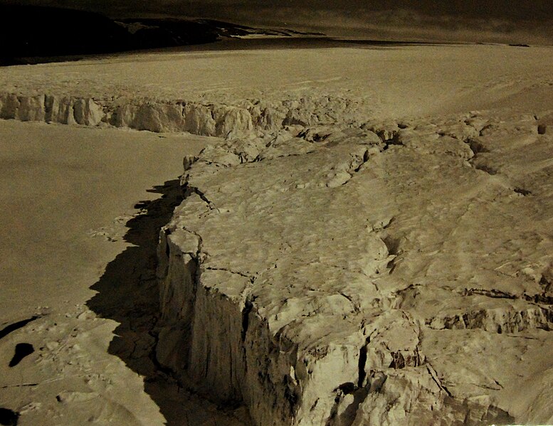
| Description | Lot 5967-4: Aerial view of the Pettiwick Glacier, Greenland. The wall of ice at that point was about 200 feet high, and this image shows a panoramic view of about 5 miles. The ice divided by the crevasses will break off later and float away with the tide and currents. Some of the larger bergs will find their way down into the North Atlantic ocean shipping lanes after drifting for many months down Baffin Bay and Davis Strait. The Coast Guard helicopter from U.S. Coast Guard icebreaker Eastwind (WAGB-279) took this photograph. Official U.S. Coast Guard Photograph, release September 1952. Photographed through Mylar sleeve. (2015/10/09). Note, the Chicago Tribune has a photograph online which claims copyright on this image. They do not have copyright as it is U.S. Coast Guard photograph. |
| Date | |
| Source | Lot 5967-4 |
| Author | National Museum of the U.S. Navy |
Licensing[edit]
.jpg&action=edit§ion=2)
| This image was originally posted to Flickr by Photograph Curator at https://flickr.com/photos/127906254@N06/22059305225 (archive). It was reviewed on 12 July 2018 by FlickreviewR 2 and was confirmed to be licensed under the terms of the Public Domain Mark. |
This file is a work of a sailor or employee of the U.S. Navy, taken or made as part of that person's official duties. As a work of the U.S. federal government, it is in the public domain in the United States.
|
 | |
| This file has been identified as being free of known restrictions under copyright law, including all related and neighboring rights. | ||
File history
Click on a date/time to view the file as it appeared at that time.
| Date/Time | Thumbnail | Dimensions | User | Comment | |
|---|---|---|---|---|---|
| current | 13:27, 12 July 2018 | | 2,140 × 1,651 (1.71 MB) | Hiàn (alt) (talk | contribs) | Transferred from Flickr via #flickr2commons |
You cannot overwrite this file.
File usage on Commons
The following 3 pages use this file:
.jpg&redirect=no)
.jpg&oldid=807749764)