File:Aerial Photo of East River Tunnel Portals.jpg
Jump to navigation
Jump to search

Size of this preview: 800 × 600 pixels. Other resolutions: 320 × 240 pixels | 640 × 480 pixels | 1,024 × 768 pixels | 1,280 × 960 pixels | 2,560 × 1,920 pixels | 4,032 × 3,024 pixels.
Original file (4,032 × 3,024 pixels, file size: 4.61 MB, MIME type: image/jpeg)
Captions
Captions
Add a one-line explanation of what this file represents
Summary
[edit]
| Description |
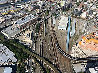
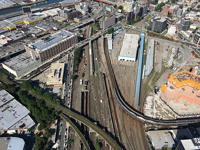
English: Photo of East River Tunnel Portals, looking west from a helicopter at 8:06 am on 7/31/17 |
| Date | |
| Source | Own work |
| Author | Chris Wallner |
| Camera location | | View this and other nearby images on: OpenStreetMap |
|---|
Licensing
[edit]
I, the copyright holder of this work, hereby publish it under the following license:
This file is licensed under the Creative Commons Attribution-Share Alike 4.0 International license.
- You are free:
- to share – to copy, distribute and transmit the work
- to remix – to adapt the work
- Under the following conditions:
- attribution – You must give appropriate credit, provide a link to the license, and indicate if changes were made. You may do so in any reasonable manner, but not in any way that suggests the licensor endorses you or your use.
- share alike – If you remix, transform, or build upon the material, you must distribute your contributions under the same or compatible license as the original.
File history
Click on a date/time to view the file as it appeared at that time.
| Date/Time | Thumbnail | Dimensions | User | Comment | |
|---|---|---|---|---|---|
| current | 02:53, 12 December 2017 | | 4,032 × 3,024 (4.61 MB) | Chris Wallner (talk | contribs) | Cross-wiki upload from en.wikipedia.org |
You cannot overwrite this file.
File usage on Commons
There are no pages that use this file.
File usage on other wikis
The following other wikis use this file:
- Usage on de.wikipedia.org
- Usage on en.wikipedia.org
- Usage on nl.wikipedia.org
- Usage on zh.wikipedia.org
Metadata
Categories:
- East River Tunnels
- Aerial photographs of Queens, New York City
- Montauk Cutoff
- IRT Flushing Line
- Hunterspoint Avenue station (LIRR)
- Views of Long Island City, Queens from above
- Arch Street Shops
- Long Island City, Queens
- Transport in Long Island City, Queens
- 21st Street (Queens)
- Queens–Midtown Expressway from Midtown Tunnel to Brooklyn-Queens Expressway
- R62A (New York City Subway car)
- 7 (New York City Subway service)
- Rail tunnel portals in the United States
- R188 (New York City Subway car)
- The Bridge (24-02 49th Avenue)