File:Admiralty Chart No 1027 Ping Hai and Mirs Bays, with Lamock, Lamon, and parts of Nangoa Islands, Published 1795.jpg
Jump to navigation
Jump to search

Size of this preview: 800 × 542 pixels. Other resolutions: 320 × 217 pixels | 640 × 433 pixels | 1,024 × 694 pixels | 1,280 × 867 pixels | 2,560 × 1,734 pixels | 6,124 × 4,148 pixels.
Original file (6,124 × 4,148 pixels, file size: 3.9 MB, MIME type: image/jpeg)
Captions
Captions
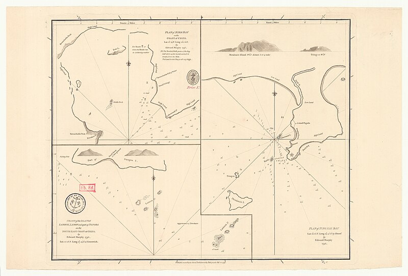
Nautical chart of Pinghai and Mirs Bays, with Lamock, Lamon, and parts of Nan'ao Islands
Summary[edit]
| Description |
English: Nautical chart of Ping Hai (Pinghai) and Mirs Bays, with Lamock, Lamon, and parts of Nangoa (Nan'ao) Islands. Plan of Mirs Bay on the coast of China Lat. 22° 29' N. Long. 114° 21' E. ; Chart of the Islands Lamock, Lamon and part of Nangoa on the south east coast of China ; Plan of Ping Hai Bay : Lat. 22° 33' N. Long. 114° 45' E by chronr. Surveyed by Edward Murphy 1793. Not current - not to be used for navigation! |
||||||||||||||||||||||||||
| Date | |||||||||||||||||||||||||||
| Source |
|
||||||||||||||||||||||||||
| Creator |
|
||||||||||||||||||||||||||
| Georeferencing | If inappropriate please set warp_status = skip to hide. | ||||||||||||||||||||||||||

Licensing[edit]
This work created by the United Kingdom Government is in the public domain.
This is because it is one of the following:
HMSO has declared that the expiry of Crown Copyrights applies worldwide (ref: HMSO Email Reply)
|
 |
File history
Click on a date/time to view the file as it appeared at that time.
| Date/Time | Thumbnail | Dimensions | User | Comment | |
|---|---|---|---|---|---|
| current | 22:12, 5 April 2024 | | 6,124 × 4,148 (3.9 MB) | Kognos (talk | contribs) | Uploaded a work by {{Creator:United Kingdom Hydrographic Office}} from {{Institution:Bibliothèque nationale de France}} with UploadWizard |
You cannot overwrite this file.
File usage on Commons
The following page uses this file: