File:Administrative map of Bulgaria during WWII.svg
Jump to navigation
Jump to search

Size of this PNG preview of this SVG file: 715 × 461 pixels. Other resolutions: 320 × 206 pixels | 640 × 413 pixels | 1,024 × 660 pixels | 1,280 × 825 pixels | 2,560 × 1,651 pixels.
Original file (SVG file, nominally 715 × 461 pixels, file size: 165 KB)
Captions
Captions
Add a one-line explanation of what this file represents
| Description |
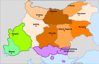
Deutsch: Administrative Karte Bulgariens während des 2. Weltkrieges mit den annektierten Gebieten in Jugoslawien und Griechenland. English: Administrative map of Bulgaria during World War II. Español: Divisiones administrativas en la Segunda Guerra Mundial. En verde anexiones a Yugoslavia y en violeta a Grecia. |
||||||||
| Date | |||||||||
| Source | en:Image:Administrative map of Bulgaria during WWII.png (GFDL) by en:User:Pakko, vectorized and modified by Chabacano | ||||||||
| Author | en:User:Pakko, vectorized and modified by Chabacano | ||||||||
| Permission (Reusing this file) |
|
||||||||
| Other versions |
Derivative works of this file:
|


File history
Click on a date/time to view the file as it appeared at that time.
| Date/Time | Thumbnail | Dimensions | User | Comment | |
|---|---|---|---|---|---|
| current | 17:29, 13 September 2021 | | 715 × 461 (165 KB) | Rowanwindwhistler (talk | contribs) | Komotiní moved. Skopi, Sofía, Ruse. |
| 20:02, 21 August 2007 |  | 715 × 461 (165 KB) | Ignacio Icke (talk | contribs) | {{Information |Description={{es|Divisiones administrativas en la Segunda Guerra Mundial. En verde anexiones a Yugoslavia y en violeta a Grecia.}} |Source=en:Image:Administrative map of Bulgaria during WWII.png (GFDL) by en:User:Pakko, vectorized |
You cannot overwrite this file.
File usage on Commons
The following 3 pages use this file:
File usage on other wikis
The following other wikis use this file:
- Usage on ast.wikipedia.org
- Usage on ca.wikipedia.org
- Usage on cs.wikipedia.org
- Usage on es.wikipedia.org
- Usage on he.wikipedia.org
- Usage on pt.wikipedia.org
- Usage on ro.wikipedia.org
- Usage on sh.wikipedia.org