File:Abandoned RAF bunker on Ibsley Common, New Forest - geograph.org.uk - 187111.jpg
Jump to navigation
Jump to search
Size of this preview: 450 × 600 pixels. Other resolutions: 180 × 240 pixels | 480 × 640 pixels.
Original file (480 × 640 pixels, file size: 168 KB, MIME type: image/jpeg)
Captions
Captions
Add a one-line explanation of what this file represents
Summary
[edit]
| Description |
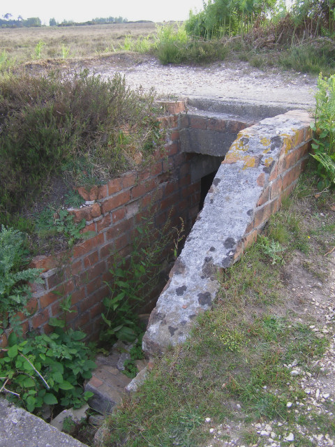
English: Abandoned RAF bunker on Ibsley Common, New Forest. A few Second World War structures survive on the plateau of Ibsley Common, above Chibden Bottom. This is the entrance to a concrete bunker, next to the site of a radar station associated with RAF Ibsley in the Avon valley below. The entrance is partially blocked with bricks, but it is still possible to see into the bunker. This structure is not marked on the OS maps. |
| Date | |
| Source | From geograph.org.uk |
| Author | Jim Champion |
| Attribution (required by the license) | Jim Champion / Abandoned RAF bunker on Ibsley Common, New Forest / |
| Object location | | View this and other nearby images on: OpenStreetMap |
|---|
_&language=en)
Licensing
[edit]

|
This image was taken from the Geograph project collection. See this photograph's page on the Geograph website for the photographer's contact details. The copyright on this image is owned by Jim Champion and is licensed for reuse under the Creative Commons Attribution-ShareAlike 2.0 license.
|
This file is licensed under the Creative Commons Attribution-Share Alike 2.0 Generic license.
Attribution: Jim Champion
- You are free:
- to share – to copy, distribute and transmit the work
- to remix – to adapt the work
- Under the following conditions:
- attribution – You must give appropriate credit, provide a link to the license, and indicate if changes were made. You may do so in any reasonable manner, but not in any way that suggests the licensor endorses you or your use.
- share alike – If you remix, transform, or build upon the material, you must distribute your contributions under the same or compatible license as the original.
- Remove redundant categories and try to put this image in the most specific category/categories
- Remove this template
- The location categories are based on information from this geonames tool and this OpenStreetMap tool combined with a database. You can also have a look at this tool from mysociety.
- The topic category from Geograph was Wartime relics (find similar images relics at Geograph)
File history
Click on a date/time to view the file as it appeared at that time.
| Date/Time | Thumbnail | Dimensions | User | Comment | |
|---|---|---|---|---|---|
| current | 14:38, 31 January 2010 | | 480 × 640 (168 KB) | GeographBot (talk | contribs) | == {{int:filedesc}} == {{Information |description={{en|1=Abandoned RAF bunker on Ibsley Common, New Forest. A few Second World War structures survive on the plateau of Ibsley Common, above Chibden Bottom. This is the entrance to a concrete bunker, next to |
You cannot overwrite this file.
File usage on Commons
There are no pages that use this file.