File:A plan of the River St. Lawrence from the Falls of Montmorenci to Sillery, with the operations of the siege of Quebec LOC 2017593669.jpg
Jump to navigation
Jump to search

Size of this preview: 783 × 600 pixels. Other resolutions: 313 × 240 pixels | 627 × 480 pixels | 1,003 × 768 pixels | 1,280 × 981 pixels | 2,560 × 1,961 pixels | 3,275 × 2,509 pixels.
Original file (3,275 × 2,509 pixels, file size: 1.54 MB, MIME type: image/jpeg)
Captions
Captions
Add a one-line explanation of what this file represents
Summary[edit]
| Description |
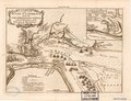
English: Relief shown by hachures. Shows fortifications and military activity in the vicinity of Québec. Includes illustrations, index to ships, etc., and indexed inset "A plan of the action gained by the English near Quebec, Sep. 13, 1759". LC copy mounted on cloth backed paper. Available also through the Library of Congress Web site as a raster image. |
||
| Title | A plan of the River St. Lawrence from the Falls of Montmorenci to Sillery, with the operations of the siege of Quebec | ||
| Shelf ID | G3454.Q4S1 1759 .P5 | ||
| Date | |||
| Source | https://www.loc.gov/item/2017593669/ | ||
| Author | Unknown author | ||
| Permission (Reusing this file) |
|
||
| Other versions |
|
||
| Location | Canada · Québec · Québec Campaign · Québec. · Québec (Province) | ||
| Part of | Military Battles And Campaigns · Cities And Towns · Catalog · American Memory · Geography And Map Division | ||
| Subject | Canada · Maps · Fortification · Québec (Québec) · Early Maps · Québec · Early Works To 1800 · Québec (Province) · Québec Campaign, Québec |

Licensing[edit]
|
This is a faithful photographic reproduction of a two-dimensional, public domain work of art. The work of art itself is in the public domain for the following reason:
The official position taken by the Wikimedia Foundation is that "faithful reproductions of two-dimensional public domain works of art are public domain".
This photographic reproduction is therefore also considered to be in the public domain in the United States. In other jurisdictions, re-use of this content may be restricted; see Reuse of PD-Art photographs for details. | ||||
File history
Click on a date/time to view the file as it appeared at that time.
| Date/Time | Thumbnail | Dimensions | User | Comment | |
|---|---|---|---|---|---|
| current | 01:35, 12 September 2018 | | 3,275 × 2,509 (1.54 MB) | Fæ (talk | contribs) | LOC Maps https://www.loc.gov/item/2017593669/ #22189 |
You cannot overwrite this file.
File usage on Commons
The following page uses this file: