File:A new map of the most frequented part of New Found Land LOC 88690193.jpg
Jump to navigation
Jump to search

Size of this preview: 778 × 600 pixels. Other resolutions: 312 × 240 pixels | 623 × 480 pixels | 997 × 768 pixels | 1,280 × 986 pixels | 2,560 × 1,973 pixels | 3,379 × 2,604 pixels.
Original file (3,379 × 2,604 pixels, file size: 1.37 MB, MIME type: image/jpeg)
Captions
Captions
Add a one-line explanation of what this file represents
Summary[edit]
| Description |
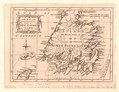
English: Relief shown pictorially. From the London magazine, v. 31, p. 408, 1762. Available also through the Library of Congress Web site as a raster image. Two copies. Copy 2, hand col. Vault |
||
| Title | A new map of the most frequented part of New Found Land | ||
| Shelf ID | G3435 1762 .K5 | ||
| Date | |||
| Source | https://www.loc.gov/item/88690193/ | ||
| Author | Kitchin, Thomas | ||
| Permission (Reusing this file) |
|
||
| Other versions |
|
||
| Location | Canada · Newfoundland And Labrador. · Newfoundland · Newfoundland And Labrador · Labrador | ||
| Part of | American Memory · General Maps · Catalog · Geography And Map Division | ||
| Subject | Early Maps · Maps · Early Works To 1800 · Canada · Newfoundland And Labrador |

Licensing[edit]
|
This is a faithful photographic reproduction of a two-dimensional, public domain work of art. The work of art itself is in the public domain for the following reason:
The official position taken by the Wikimedia Foundation is that "faithful reproductions of two-dimensional public domain works of art are public domain".
This photographic reproduction is therefore also considered to be in the public domain in the United States. In other jurisdictions, re-use of this content may be restricted; see Reuse of PD-Art photographs for details. | ||||
File history
Click on a date/time to view the file as it appeared at that time.
| Date/Time | Thumbnail | Dimensions | User | Comment | |
|---|---|---|---|---|---|
| current | 23:17, 18 May 2018 | | 3,379 × 2,604 (1.37 MB) | Fæ (talk | contribs) | LOC Maps https://www.loc.gov/item/88690193/ #11040 |
You cannot overwrite this file.
File usage on Commons
The following page uses this file: