File:A map of the routs of the Russian embassy toPersia in 1746, also of Mr. George Thompson 's journey on the East and the author's travels on the South coast of the Caspian sea, with Mr. Van Mierop's journey to Mesched... - btv1b85930726.jpg
Jump to navigation
Jump to search

Size of this preview: 635 × 599 pixels. Other resolutions: 254 × 240 pixels | 508 × 480 pixels | 814 × 768 pixels | 1,085 × 1,024 pixels | 2,169 × 2,048 pixels | 8,146 × 7,690 pixels.
Original file (8,146 × 7,690 pixels, file size: 9.48 MB, MIME type: image/jpeg)
Captions
Captions
Add a one-line explanation of what this file represents
Summary[edit]
| Warning | The original file is very high-resolution. It might not load properly or could cause your browser to freeze when opened at full size. |
|---|
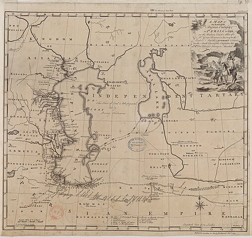
| A map of the routs of the Russian embassy toPersia in 1746, also of Mr. George Thompson 's journey on the East and the author's travels on the South coast of the Caspian sea, with Mr. Van Mierop's journey to Mesched / J. Gibson delin. et sculp.
( |
|||||||||||||||||||||||||||
|---|---|---|---|---|---|---|---|---|---|---|---|---|---|---|---|---|---|---|---|---|---|---|---|---|---|---|---|
| Author |
Gibson, John (17..-1792). Cartographe. Graveur |
||||||||||||||||||||||||||
| Title |
A map of the routs of the Russian embassy toPersia in 1746, also of Mr. George Thompson 's journey on the East and the author's travels on the South coast of the Caspian sea, with Mr. Van Mierop's journey to Mesched / J. Gibson delin. et sculp. |
||||||||||||||||||||||||||
| Description |
Français : Sujet : Van Mierop (17..-17..? ; voyageur) -- Voyages -- Asie
Thompson, George (17..-17..? ; voyageur) -- Voyages -- Asie Gibson, John (17..-1792) -- Voyages -- Asie Caspienne, Mer -- Environs -- Itinéraires Aral, Mer d' -- Environs -- Itinéraires Grande Tartarie -- Sud-Ouest -- Itinéraires Personnages Appartient à l’ensemble documentaire : AnvilMF Appartient à l’ensemble documentaire : MAEDI008 Appartient à l’ensemble documentaire : MAEDIGen0 Couverture : Asie (parties) Langue : anglais Éditeur : [s.n.] |
||||||||||||||||||||||||||
| Date | 1753 | ||||||||||||||||||||||||||
| Dimensions | height: 51 cm (20 in); width: 47.5 cm (18.7 in) | ||||||||||||||||||||||||||
| Collection |
|
||||||||||||||||||||||||||
| References |
Français : Notice de recueil : http://catalogue.bnf.fr/ark:/12148/cb40577015h
Appartient à : Collection d'Anville ; 06781 Notice du catalogue : http://catalogue.bnf.fr/ark:/12148/cb406553775 |
||||||||||||||||||||||||||
| Source/Photographer |
Français : Bibliothèque nationale de France, département Cartes et plans, GE DD-2987 (6781)
Bibliothèque nationale de France |
||||||||||||||||||||||||||
| Permission (Reusing this file) |
|
||||||||||||||||||||||||||

File history
Click on a date/time to view the file as it appeared at that time.
| Date/Time | Thumbnail | Dimensions | User | Comment | |
|---|---|---|---|---|---|
| current | 08:39, 13 July 2022 | | 8,146 × 7,690 (9.48 MB) | Gzen92Bot (talk | contribs) | Gallica btv1b85930726 |
You cannot overwrite this file.
File usage on Commons
The following page uses this file: