File:A map of Pennsylvania exhibiting not only the improved parts of that province, but also its extensive frontiers, laid down from actual surveys, and chiefly from the late map of W. Scull published in 1770 - btv1b530529199.jpg
Jump to navigation
Jump to search

Size of this preview: 800 × 430 pixels. Other resolutions: 320 × 172 pixels | 640 × 344 pixels | 1,024 × 551 pixels | 1,280 × 689 pixels | 2,560 × 1,377 pixels | 16,915 × 9,099 pixels.
Original file (16,915 × 9,099 pixels, file size: 20.06 MB, MIME type: image/jpeg)
Captions
Captions
Add a one-line explanation of what this file represents
Summary[edit]
| Warning | The original file is very high-resolution. It might not load properly or could cause your browser to freeze when opened at full size. |
|---|
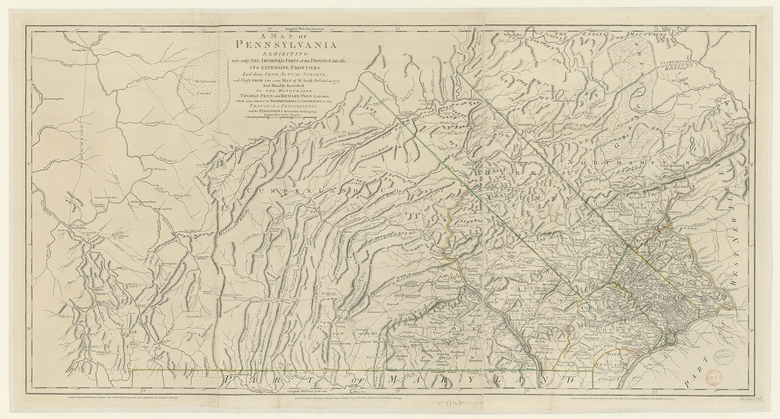
| A map of Pennsylvania exhibiting not only the improved parts of that province, but also its extensive frontiers, laid down from actual surveys, and chiefly from the late map of W. Scull published in 1770
( |
|||||||||||||||||||||||||||
|---|---|---|---|---|---|---|---|---|---|---|---|---|---|---|---|---|---|---|---|---|---|---|---|---|---|---|---|
| Author |
Scull, William (1739-1784). Cartographe |
||||||||||||||||||||||||||
| Title |
A map of Pennsylvania exhibiting not only the improved parts of that province, but also its extensive frontiers, laid down from actual surveys, and chiefly from the late map of W. Scull published in 1770 |
||||||||||||||||||||||||||
| Description |
Français : Sujet : Pennsylvanie, Colonie de la -- 1770
Échelle(s) : 30 english miles 69,5 to a degree [= 13 cm] Appartient à l’ensemble documentaire : AnvilAmN Appartient à l’ensemble documentaire : FranceAm Appartient à l’ensemble documentaire : MAEDI008 Appartient à l’ensemble documentaire : MAEDIGen0 Couverture : Amérique Langue : anglais Éditeur : printed for Rob. Sayer & J. Bennett (London) |
||||||||||||||||||||||||||
| Date | 1775 | ||||||||||||||||||||||||||
| Dimensions | height: 138 cm (54.3 in); width: 73 cm (28.7 in) | ||||||||||||||||||||||||||
| Collection |
|
||||||||||||||||||||||||||
| References |
Français : Notice de recueil : http://catalogue.bnf.fr/ark:/12148/cb40577015h
Appartient à : Collection d'Anville ; 08747 B Notice du catalogue : http://catalogue.bnf.fr/ark:/12148/cb40606678j |
||||||||||||||||||||||||||
| Source/Photographer |
Français : Bibliothèque nationale de France, département Cartes et plans, GE DD-2987 (8747 B)
Bibliothèque nationale de France |
||||||||||||||||||||||||||
| Permission (Reusing this file) |
|
||||||||||||||||||||||||||

File history
Click on a date/time to view the file as it appeared at that time.
| Date/Time | Thumbnail | Dimensions | User | Comment | |
|---|---|---|---|---|---|
| current | 00:10, 13 July 2022 | | 16,915 × 9,099 (20.06 MB) | Gzen92Bot (talk | contribs) | Gallica btv1b530529199 |
You cannot overwrite this file.
File usage on Commons
The following page uses this file: