File:A map of Brazil main rock groups karst areas and formations with obligatory cave-dwelling species.jpg
Jump to navigation
Jump to search
Size of this preview: 800 × 566 pixels. Other resolutions: 320 × 226 pixels | 640 × 453 pixels | 1,024 × 725 pixels | 1,280 × 906 pixels | 1,512 × 1,070 pixels.
Original file (1,512 × 1,070 pixels, file size: 543 KB, MIME type: image/jpeg)
Captions
Captions
Add a one-line explanation of what this file represents
Summary[edit]
| Description |
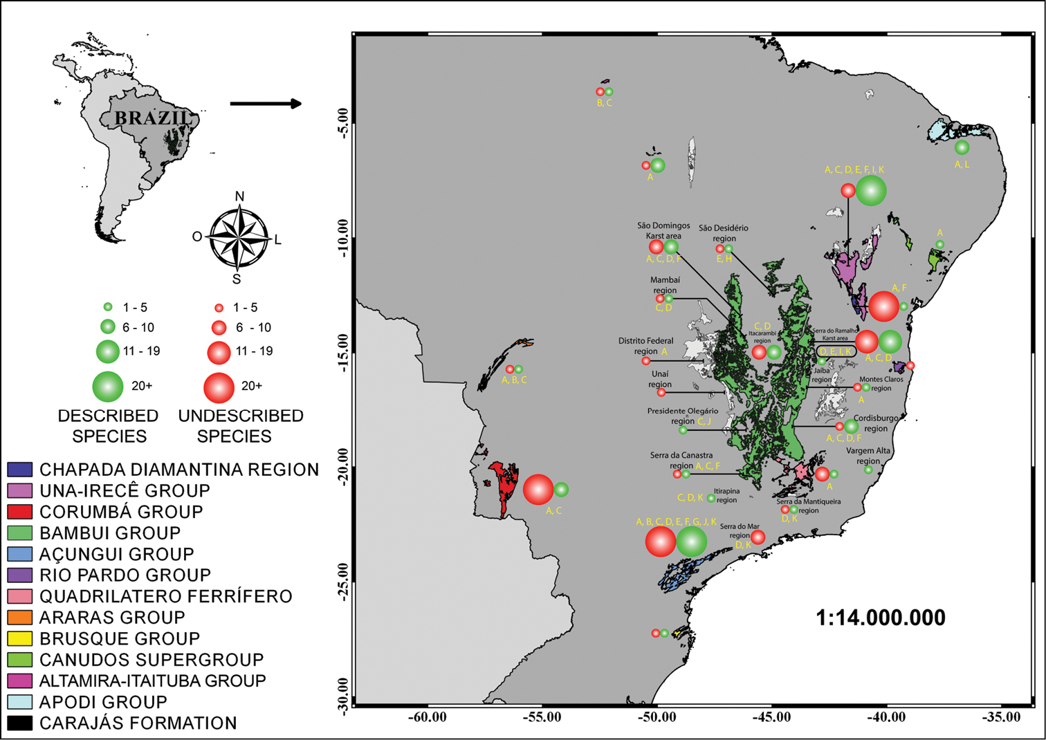
English: Map of Brazil with main rock groups, karst areas, and formations with obligatory cave-dwelling species. Threats are indicated by letters as follows: A Minig B Reservoir construction C Deforestation for pastures D Deforestation for agriculture E Pollution of subterranean drainages F Tourism G Land conflict H Road construction, I Lowering of water table J Small hydroelectric power station buildings, K Pesticides L Natural gas and oil exploration. For Bambuí group, we grouped as follows (see Table 1 for distinction): Mambaí region - Mambaí and Posse municipalities; Distrito Federal region - Distrito Federal region plus Formosa and Padre Bernardo municipalities; Presidente Olegário region - Presidente Olegário and Vazante municipalities; Serra da Canastra region - São Roque de Minas, Arcos and Pains municipalities; Cordisburgo region - Cordisburgo, Matozinhos, Sete Lagoas, Morro do Pilar, Monjolos and Lagoa Santa municipalities; Montes Claros region - Montes Claros, Coração de Jesus and Luislândia municipalities. |
| Date | |
| Source | Gallão JE, Bichuette ME (2018) Brazilian obligatory subterranean fauna and threats to the hypogean environment. ZooKeys 746: 1-23. https://doi.org/10.3897/zookeys.746.15140 |
| Author | Jonas Eduardo Gallão, Maria Elina Bichuette |
Licensing[edit]
This file is licensed under the Creative Commons Attribution 4.0 International license.
- You are free:
- to share – to copy, distribute and transmit the work
- to remix – to adapt the work
- Under the following conditions:
- attribution – You must give appropriate credit, provide a link to the license, and indicate if changes were made. You may do so in any reasonable manner, but not in any way that suggests the licensor endorses you or your use.
File history
Click on a date/time to view the file as it appeared at that time.
| Date/Time | Thumbnail | Dimensions | User | Comment | |
|---|---|---|---|---|---|
| current | 02:49, 29 August 2018 | | 1,512 × 1,070 (543 KB) | Ixocactus (talk | contribs) | {{Information |description ={{en|1=Map of Brazil with main rock groups, karst areas, and formations with obligatory cave-dwelling species. Threats are indicated by letters as follows: A Minig B Reservoir construction C Deforestation for pastures D Deforestation for agriculture E Pollution of subterranean drainages F Tourism G Land conflict H Road construction, I Lowering of water table J Small hydroelectric power station buildings, K Pesticides L Natural gas and oil exploration. For Bambuí... |
You cannot overwrite this file.
File usage on Commons
There are no pages that use this file.