File:A chart of the north part of America describing the sea coast of Groenland, Davies streights, Baffin bay, Hudson streights, Buttens bay and James - by John Seller, John Colson, Wilham Fisher, James Atkinson and John... - btv1b85958767.jpg

Original file (8,818 × 7,150 pixels, file size: 10.71 MB, MIME type: image/jpeg)
Captions
Captions
Summary[edit]
| Warning | The original file is very high-resolution. It might not load properly or could cause your browser to freeze when opened at full size. |
|---|
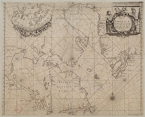
| A chart of the north part of America describing the sea coast of Groenland, Davies streights, Baffin bay, Hudson streights, Buttens bay and James / by John Seller, John Colson, Wilham Fisher, James Atkinson and John Thornton
( |
|||||||||||||||||||||||||||
|---|---|---|---|---|---|---|---|---|---|---|---|---|---|---|---|---|---|---|---|---|---|---|---|---|---|---|---|
| Author |
Seller, John (16..-1697). Cartographe Thornton, John (1641-1708). Cartographe Colson, John (16..-17..? ; mathématicien). Cartographe Atkinson, James (16..-17..? ; mathématicien). Cartographe Fisher, William (16..-17..? ; éditeur). Cartographe |
||||||||||||||||||||||||||
| Title |
A chart of the north part of America describing the sea coast of Groenland, Davies streights, Baffin bay, Hudson streights, Buttens bay and James / by John Seller, John Colson, Wilham Fisher, James Atkinson and John Thornton |
||||||||||||||||||||||||||
| Description |
Français : Sujet : Cartouches (ornement)
Groenland, Île du -- Côtes Davis, Détroit de Labrador, Mer du Baffin, Baie de Hudson, Baie d' Amérique du Nord -- Nord-Est -- Côtes Monde -- Hémisphère nord Personnages Roses des vents Navires à voiles Échelle(s) : [ca 1:8 300 000], 120 English leagues 20 to a degree [= 9,1 cm] Appartient à l’ensemble documentaire : AnvilAmN Appartient à l’ensemble documentaire : FranceAm Appartient à l’ensemble documentaire : MAEDI008 Appartient à l’ensemble documentaire : MAEDIGen0 Couverture : Groenland (Danemark) Détroit de Davis Mer du Labrador Baie de Baffin Baie d'Hudson Amérique du Nord Monde Langue : anglais Éditeur : John Thornton () |
||||||||||||||||||||||||||
| Date | 1685 | ||||||||||||||||||||||||||
| Dimensions | height: 54.5 cm (21.4 in); width: 44 cm (17.3 in) | ||||||||||||||||||||||||||
| Collection |
|
||||||||||||||||||||||||||
| References |
Français : Notice de recueil : http://catalogue.bnf.fr/ark:/12148/cb40577015h
Appartient à : Collection d'Anville ; 08555 Notice du catalogue : http://catalogue.bnf.fr/ark:/12148/cb40600809t |
||||||||||||||||||||||||||
| Source/Photographer |
Français : Bibliothèque nationale de France, département Cartes et plans, GE DD-2987 (8555)
Bibliothèque nationale de France |
||||||||||||||||||||||||||
| Permission (Reusing this file) |
|
||||||||||||||||||||||||||

File history
Click on a date/time to view the file as it appeared at that time.
| Date/Time | Thumbnail | Dimensions | User | Comment | |
|---|---|---|---|---|---|
| current | 13:09, 29 July 2022 | | 8,818 × 7,150 (10.71 MB) | Gzen92Bot (talk | contribs) | Gallica btv1b85958767 |
You cannot overwrite this file.
File usage on Commons
The following page uses this file: