File:A broad interpretation of the borders of Conventus Scallabitanus and the Lusitania Province (Interpretation Nº1).png
Jump to navigation
Jump to search

Size of this preview: 800 × 450 pixels. Other resolutions: 320 × 180 pixels | 640 × 360 pixels | 1,024 × 576 pixels | 1,280 × 720 pixels | 1,920 × 1,080 pixels.
Original file (1,920 × 1,080 pixels, file size: 3.61 MB, MIME type: image/png)
Captions
Captions
Add a one-line explanation of what this file represents
Summary[edit]
.png&action=edit§ion=1)
| Description |
English: Own Work. The relief base map was taken from maps-for-free.com, itself derived from OpenStreetMap
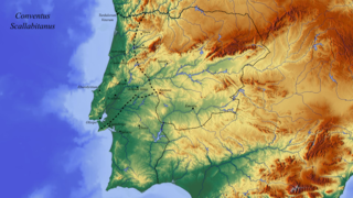
A broad interpretation focused on the borders of Conventus Scallabitanus, but also depicts Conventus Pacensis and Emeritensis. Based on the interpretation (with some changes) of - TRANOY, A.; SILLIÈRES, P.; SALINAS de FRÍAS, M.; MANTAS V.G.; GORGES, J.G.; ALARCÃO, J. (1990) – Propositions pour un nouveau tracé des limites anciennes de la Lusitanie romaine. In Les villes de Lusitanie romaine: hierarchies et territoires, table ronde internationale du CNRS. Paris, Centre National de la Recherche Scientifique. P. 319-329.
Português: Obra do próprio. O mapa de base foi retirado de (maps-for-free.com)
Traçado conjectural focado nos limites do Conventus Scallabitanus, mas também retrata o Conventus Pacensis e Emeritensis. Baseado na interpretação de (com algumas alterações) - TRANOY, A.; SILLIÈRES, P.; SALINAS de FRÍAS, M.; MANTAS V.G.; GORGES, J.G.; ALARCÃO, J. (1990) – Propositions pour un nouveau tracé des limites anciennes de la Lusitanie romaine. In Les villes de Lusitanie romaine: hierarchies et territoires, table ronde internationale du CNRS. Paris, Centre National de la Recherche Scientifique. P. 319-329. |
| Date | |
| Source | Own work, derived from OpenStreetMap |
| Author | Diogo AArq |
Licensing[edit]
.png&action=edit§ion=2)
This file is licensed under the Creative Commons Attribution-Share Alike 2.0 Generic license.
Attribution: OpenStreetMap
- You are free:
- to share – to copy, distribute and transmit the work
- to remix – to adapt the work
- Under the following conditions:
- attribution – You must give appropriate credit, provide a link to the license, and indicate if changes were made. You may do so in any reasonable manner, but not in any way that suggests the licensor endorses you or your use.
- share alike – If you remix, transform, or build upon the material, you must distribute your contributions under the same or compatible license as the original.
File history
Click on a date/time to view the file as it appeared at that time.
| Date/Time | Thumbnail | Dimensions | User | Comment | |
|---|---|---|---|---|---|
| current | 19:15, 5 July 2017 | | 1,920 × 1,080 (3.61 MB) | Diogo AArq (talk | contribs) | User created page with UploadWizard |
You cannot overwrite this file.
File usage on Commons
There are no pages that use this file.
File usage on other wikis
The following other wikis use this file:
- Usage on pt.wikipedia.org
.png&oldid=875752876)