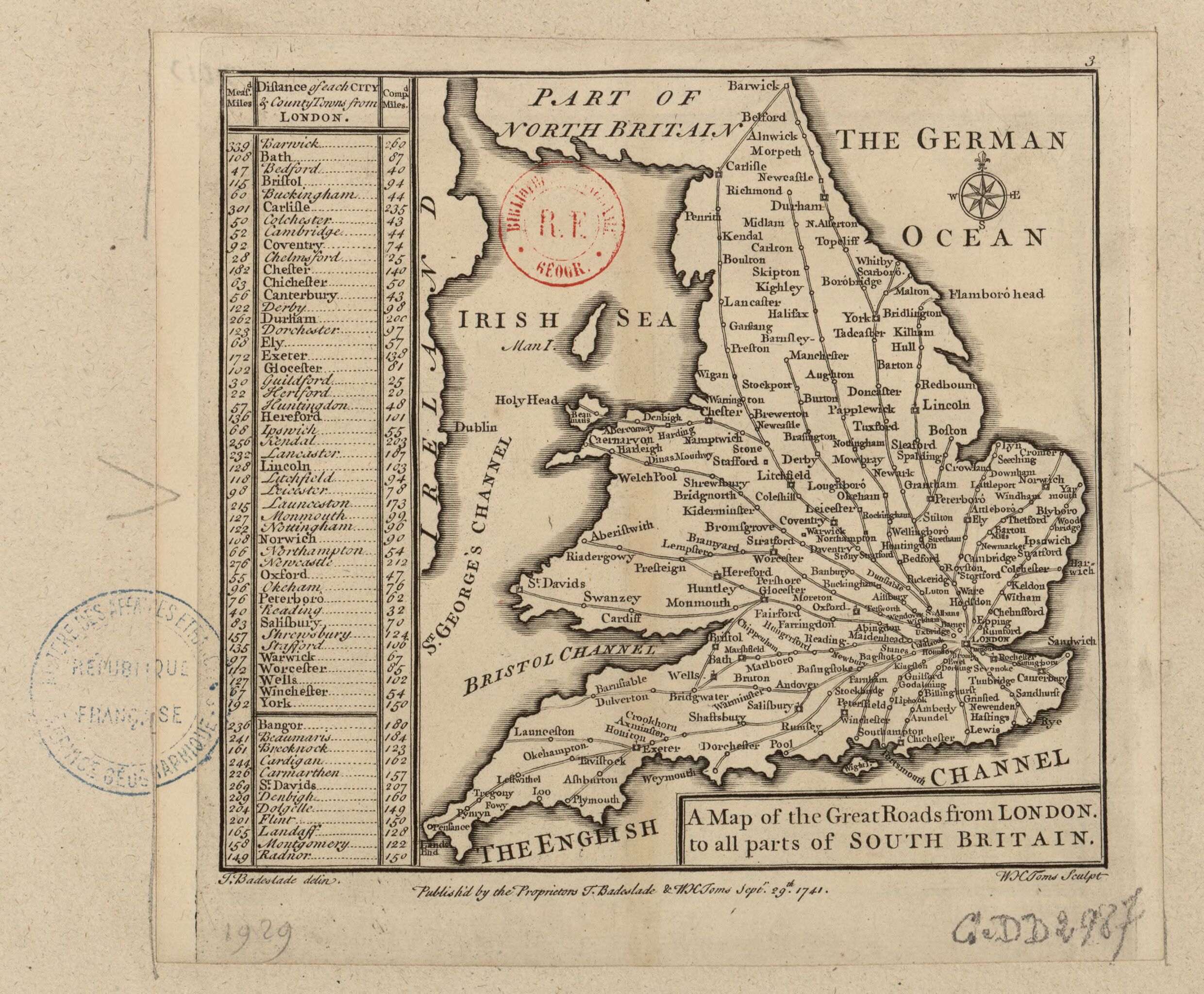
File:A Map of the Great Roads from London to all parts of South Britain - T. Badeslade delin. ; W.H. Toms sculp. - btv1b53056370v.jpg
Jump to navigation
Jump to search
Size of this preview: 726 × 600 pixels. Other resolutions: 291 × 240 pixels | 581 × 480 pixels | 930 × 768 pixels | 1,240 × 1,024 pixels | 2,480 × 2,048 pixels.
Original file (2,480 × 2,048 pixels, file size: 900 KB, MIME type: image/jpeg)
Captions
Captions
Add a one-line explanation of what this file represents
Summary[edit]
| A Map of the Great Roads from London to all parts of South Britain / T. Badeslade delin. ; W.H. Toms sculp.
( |
|||||||||||||||||||||||||||
|---|---|---|---|---|---|---|---|---|---|---|---|---|---|---|---|---|---|---|---|---|---|---|---|---|---|---|---|
| Author |
Badeslade, Thomas (1718-1750). Cartographe Toms, William Henry (17..-17..). Graveur |
||||||||||||||||||||||||||
| Title |
A Map of the Great Roads from London to all parts of South Britain / T. Badeslade delin. ; W.H. Toms sculp. |
||||||||||||||||||||||||||
| Description |
Français : Sujet : Angleterre
Pays de Galles Échelle(s) : [Sans échellle?] Appartient à l’ensemble documentaire : AnvilEur Appartient à l’ensemble documentaire : MAEDI008 Appartient à l’ensemble documentaire : MAEDIGen0 Couverture : Royaume-Uni – Angleterre Royaume-Uni – Pays de Galles Langue : anglais Éditeur : Publish'd by the Proprietors T. Badeslade & W.H. Toms (London) |
||||||||||||||||||||||||||
| Date | 1741 | ||||||||||||||||||||||||||
| Dimensions | height: 15.5 cm (6.1 in); width: 15.5 cm (6.1 in) | ||||||||||||||||||||||||||
| Collection |
|
||||||||||||||||||||||||||
| References |
Français : Notice de recueil : http://catalogue.bnf.fr/ark:/12148/cb40577015h
Appartient à : Collection d'Anville ; 01929 Notice du catalogue : http://catalogue.bnf.fr/ark:/12148/cb411204129 Extrait de Chorographia Britanniae. Or A Set of Maps of all the Counties in England and Wales... This Collection (conveying a more comprehensive Idea of South Britain than any thing hitherto publish'd) was first Drawn, and compiled into a Pocket Book by Order and for the Use of his late Majesty King George I. By Thomas Badeslade Surveyor and Engineer, and now neatly Engrav'd by Will. Henry Toms. Printed for and Sold by W.H. Toms Engraver, in Union Court, near Hatton Garden, Holbourn. 1742, . |
||||||||||||||||||||||||||
| Source/Photographer |
Français : Bibliothèque nationale de France, département Cartes et plans, GE DD-2987 (1929)
Bibliothèque nationale de France |
||||||||||||||||||||||||||
| Permission (Reusing this file) |
|
||||||||||||||||||||||||||

File history
Click on a date/time to view the file as it appeared at that time.
| Date/Time | Thumbnail | Dimensions | User | Comment | |
|---|---|---|---|---|---|
| current | 23:07, 24 July 2022 | | 2,480 × 2,048 (900 KB) | Gzen92Bot (talk | contribs) | Gallica btv1b53056370v |
You cannot overwrite this file.
File usage on Commons
The following page uses this file: