File:A Drawing (with a Western Perspective) of the East Indies from the Promontory of Good Hope to Cape Comorin WDL2915.png
Jump to navigation
Jump to search
Size of this preview: 702 × 600 pixels. Other resolutions: 281 × 240 pixels | 562 × 480 pixels | 899 × 768 pixels | 1,199 × 1,024 pixels.
Original file (1,199 × 1,024 pixels, file size: 2.07 MB, MIME type: image/png)
Captions
Captions
Add a one-line explanation of what this file represents
Summary[edit]
_of_the_East_Indies_from_the_Promontory_of_Good_Hope_to_Cape_Comorin_WDL2915.png&action=edit§ion=1)
| Author |
Русский: Вит, Фредерик де
Français : Wit, Frederik de
English: Wit, Frederik de
中文:维特, 弗雷德里克·迪
Português: Wit, Frederik de
العربية: ويت, فريدريك دي
Español: Wit, Frederik de |
| Title |
Русский: Рисунок (с западной перспективы) Ост-Индии с выступа между мысом Доброй Надежды и мысом Коморин
Français : Un Dessin (avec une perspective occidentale) de l'est de l'Inde, du promontoire de Bonne Espérance au Cap Comorin
English: A Drawing (with a Western Perspective) of the East Indies from the Promontory of Good Hope to Cape Comorin
中文:从好望角到科摩林角的东印度图片(西方视角)
Português: Um Desenho (com uma Perspectiva Ocidental) das Índias Orientais a Partir do Promontório da Boa Esperança até o Cabo Comorin
العربية: رسم جزر الهند الشرقية (بمنظور غربي) نتوء رأس الرجاء الصالح إلى رأس كومورن
Español: Un Dibujo (con una perspectiva desde el oeste) de las Indias Orientales desde el promontorio del Cabo de Buena Esperanza hacia el Cabo Comorin |
| Description |
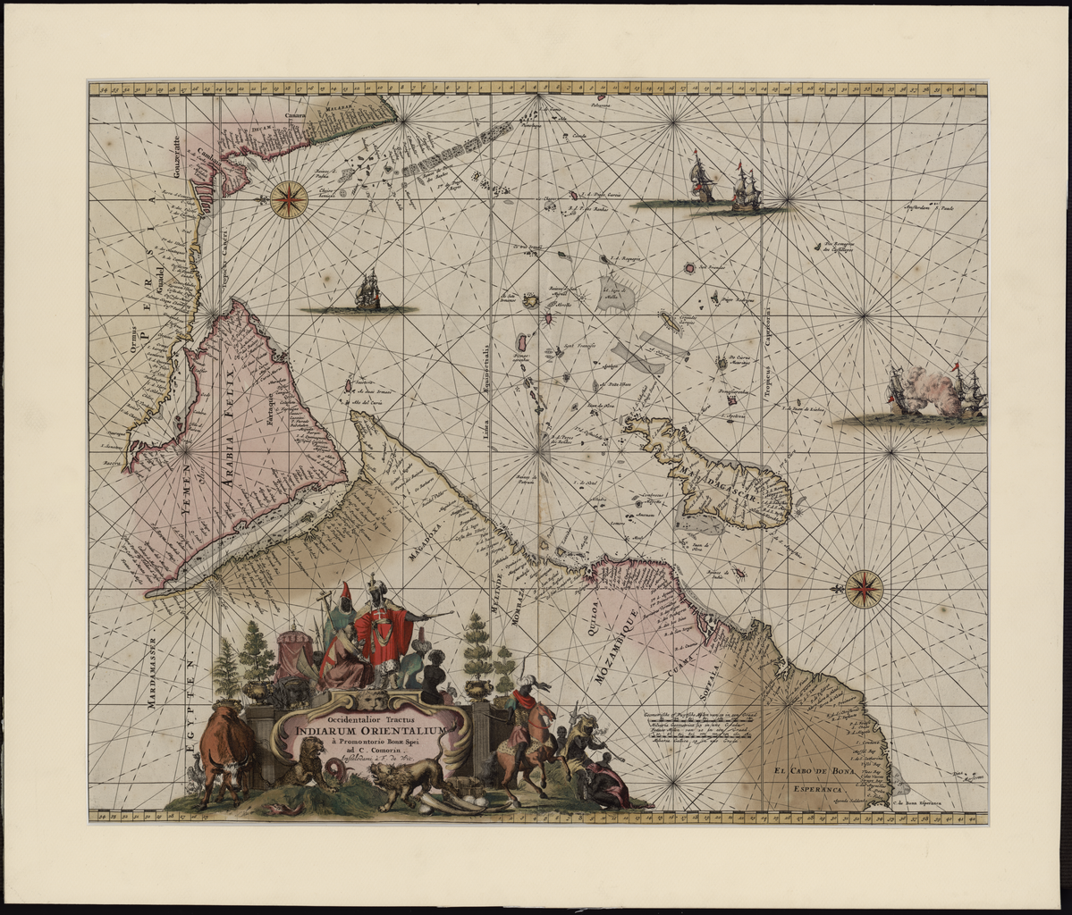
Русский: На этой карте-портолане голландского гравера, издателя и продавца картографической продукции Фредерика де Вита (1629 или 1630-1706 гг.) изображен Индийский океан от мыса Доброй Надежды до западного побережья Индии (Малабар). Впервые карта была издана в 1675 году, а затем переиздана в 1715 году. Карта ориентирована на восток. Кишм помещен на территории современных Объединенных Арабских Эмиратов и назван Кваро или Квиксими. Очертания Аравийского или Персидского залива отличаются от других карт. К северу от Бахрейна есть большой остров под названием Квезими — возможно, что это вариант написания Кишм. Хорфан изображен дважды: один раз на территории современных Арабских Эмиратов в Заливе Корска, а второй раз со стороны Омани с названием Орфакан. Регион Маскалат находится в центре Аравийского полуострова, а город с таким же названием расположен к югу от Таблана, недалеко от Аравийского побережья. Топоним Ормуз находится рядом с Оманом и современными ОАЭ. Аравийский залив назван "Mare Elcatif ol Sinus Persicus" (Аль Катиф, Персидский залив), а Красное море отмечено как "Mare Rubrum turcis Mare de Mecca olim Sinus Arabicus" (Красное море, названное турками Морем Мекки и ранее известное как Аравийский залив).
Аравийский залив; Аравийский полуостров; Персидский залив Français : Cette carte portolan par le graveur, éditeur et vendeur de cartes hollandais Frederick de Wit (1629 ou 1630-1706) montre l'Océan Indien du Cap de Bonne-Espérance à la côte ouest de l'Inde (Malabar). La carte fut publiée pour la première fois en 1675 et une réimpression réalisée en 1715. Elle est orientée à l'est dans sa partie supérieure. Kishm est placé dans les actuels Émirats Arabes Unis (EAU) et répété comme “Quaro” et “Quiximi.” La forme du Golfe Arabique ou Persique diffère de celle apparaissant sur d'autres cartes. Une grande île apparaît au nord de l'Île de Bahreïn nommée “Quezimi,” vraisemblablement une autre version de Qishm. Khorfan est indiqué deux fois : sur un site des actuels EAU dans le Golfe de Corsca et une seconde fois sur la partie Omani, où il est appelé “Orfacan.” La région de Mascalat est située au centre de la Péninsule arabique, alors que la ville du même nom se trouve au sud de Tablan, non loin de la côte arabique. "Ormuz", un nom territorial, se trouve vers Oman et les actuels EAU. Le Golfe arabique est appelé “Mare Elcatif ol Sinus Persicus” (Al Qatif, Golfe persique), alors que la Mer rouge est désignée “Mare Rubrum turcis Mare de Mecca olim Sinus Arabicus” (Mer rouge, nommée Mer de la mecque par les Turcs et auparavant connue comme le Golfe arabique).
Golfe Arabique; Péninsule arabique; Golfe Persique English: This portolan map by the Dutch engraver, publisher, and map seller Frederick de Wit (1629 or 1630-1706) shows the Indian Ocean from the Cape of Good Hope to the west coast of India (Malabar). The map was first published in 1675 and was reprinted in 1715. It is oriented with east at the top. Kishm is placed in the present-day United Arab Emirates (UAE) and repeated as “Quaro” and “Quiximi.” The shape of the Arabian or Persian Gulf differs from that shown on other maps. There is a big island north of Bahrain Island named “Quezimi,” most likely another version of Qishm. Khorfan is shown twice: at one location in the present-day UAE in the Gulf of Corsca and the second on the Omani side, where it is called “Orfacan.” Mascalat, the region, is located at the center of the Arabian Peninsula, while the town of the same name is found south of Tablan, not far from the Arabian coast. “Ormuz,” a territorial name, is found around Oman and the present-day UAE. The Arabian Gulf is called “Mare Elcatif ol Sinus Persicus” (Al Qatif, Persian Gulf), while the Red Sea is marked “Mare Rubrum turcis Mare de Mecca olim Sinus Arabicus” (Red Sea, named Sea of Mecca by Turks and formerly known as the Arabian Gulf).
Arabian Gulf; Arabian Peninsula; Persian Gulf 中文:这幅荷兰雕刻师、出版商兼地图销售商费德克勒克·德·威特(1629 或 1630-1706 年)的波多兰航海图覆盖了从好望角到印度西海岸(马拉巴)的印度洋地区。 该地图首先出版于 1675 年,1715 年重印。 该地图以上为东。 该地图上的 Kishm 位于当今的阿拉伯联合酋长国(阿联酋)境内,重复出现时被写成“Quaro”和“Quiximi”。 该地图所描绘的阿拉伯海湾或波斯湾的形状与其他地图不同。 巴林岛的北面标有一处大岛屿,岛屿的名称是“Quezimi ”,该名称很可能也是 Qishm 的另一种叫法 。 Khorfan 在地图上出现了两次:其中一处位于 Corsca 海湾今天的阿联酋境内,另一处位于阿曼旁边,被称作“Orfacan”。 地图上的 Mascalat 地区位于阿拉伯半岛的中央,而叫相同名字的一处城镇则位于 Tablan 的南面,距离阿拉伯海岸旁不远。 地图上的“Ormuz”这一地名在阿曼和当今的阿联酋境内有标注。 阿拉伯海湾被称为“Mare Elcatif ol Sinus Persicus”(Al Qatif,波斯湾),而红海标注为“Mare Rubrum turcis Mare de Mecca olim Sinus Arabicus” (红海,土耳其人称其为麦加海,早前被称为阿拉伯海湾)。
阿拉伯湾; 阿拉伯半岛; 波斯湾 Português: Esta carta de navegação portulana, do gravador, editor e vendedor de mapas holandês Frederick de Wit (1629 ou 1630-1706) mostra o Oceano Índico, do Cabo da Boa Esperança até a costa oeste da Índia (Malabar). O mapa foi publicado, pela primeira vez, em 1675 e foi reimpresso em 1715. Está orientado com o leste na parte superior. Kishm está localizada nos atuais Emirados Árabes Unidos (EAU) e está repetida como "Quaro' e "Quiximi'. O formato do Golfo Arábico ou Pérsico difere daquele mostrado em outros mapas. Há uma grande ilha ao norte da Ilha de Bahrain, chamada "Quezimi," muito provavelmente uma outra versão de Qishm. Khorfan é mostrada duas vezes: em um local nos atuais EAU, no Golfo de Corsca e, na segunda, no lado de Omã, onde é chamada de "Orfacan". A região de Mascalat está localizada no centro da Península Arábica, enquanto que a cidade do mesmo nome encontra-se ao sul de Tablan, não muito longe da costa árabe. "Ormuz", um nome territorial, encontra-se perto de Omã e dos atuais Emirados Árabes Unidos. O Golfo Arábico é chamado de "Mare Elcatif ol Sinus Persicus" (Al Qatif, Golfo Pérsico), enquanto que o Mar Vermelho está marcado como "Mare Rubrum Turcis Mare de Mecca Olim Sinus Arabicus" (Mar Vermelho, chamado de Mar de Meca pelos Turcos e anteriormente conhecido como Golfo Arábico).
Golfo Arábico; Península Arábica; Golfo Pérsico العربية: هذه الخريطة البورتلانية لفريدريك دي فيت (1629 أو 1630-1706)، النقاش والناشر وبائع الخرائط الهولندي، تظهر المحيط الهندي من رأس الرجاء الصالح حتى الساحل الغربي للهند (مالابار). نُشرت الخريطة لأول مرة في 1675 وأعيد طبعها في 1715. وهي موجهة بحيث تكون جهة الشرق في الأعلى. وُضعت كشم في دولة الإمارات العربية التحدة حاليا مع تكرار اسمها كـ "قوارو" و"قيكسيمي". ويختلف شكل الخليج العربي أو الفارسي عن غيره في خرائط أخرى. وثمة جزيرة كبيرة إلى الشمال من جزيرة البحرين اسمها "قويزيمي"، وعلى الأرجح صيغة أخرى لقشم. وتظهر خورفان مرتين: ففي موقع واحد في الإمارات العربية المتحدة حاليا في خليج كورسكا وفي موقع ثان على الجانب العماني حيث اسمها "أورفاكان". كما تقع منطقة مسكلات في وسط شبه الجزيرة العربية بينما تقع البلدة التي تحمل نفس الاسم إلى الجنوب من تبلان التي لا تبعد كثيرا من الساحل العربي. وتوجد "أوموز"، وهذا اسم إقليمي، حول عمان ودولة الإمارات العربية المتحدة حاليا. ويسمى الخليج العربي باسم "ماري الكاتيف أل سينوس بيرسيكوس" (القطيف، الخليج الفارسي)، بينما حُدد البحر الأحمر "ماري ربرم توركيس ماري دي ميكا أوليم سينوس أرابيكوس" (البحر الأحمر، المسمى بحر مكة من قبل الأتراك والمعروف سابقا بالخليج العربي).
الخليج العربي; شبه الجزيرة العربية; الخليج الفارسي Español: Este mapa portulano del grabador, editor y vendedor de mapas holandés, Frederick de Wit (1629 o 1630-1706), muestra el Océano Índico desde el Cabo de Buena Esperanza hasta la costa occidental de la India (Malabar). El mapa fue publicado por primera vez en 1675 y fue reimpreso en 1715. Está orientado con el este en la parte superior. Kishm está colocado en el actual lugar de los Emiratos Árabes Unidos (EAU) y se repite como "Quaro" y "Quiximi". La forma del Golfo Pérsico o Arábigo difiere de la que aparece en otros mapas. Hay una gran isla al norte de la isla de Bahrein llamada "Quezimi", probablemente otra versión de Qishm. Khorfan aparece dos veces: en un lugar en los actuales EAU en el Golfo de Corsca y el segundo en el lado de Omán, donde se le llama "Orfacan". Mascalat, la región, está situada en el centro de la Península Arábiga, mientras que el pueblo del mismo nombre se encuentra al sur de Tablan, no lejos de la costa de Arabia. "Ormuz", un nombre territorial, se encuentra alrededor de Omán y de los actuales Emiratos Árabes Unidos. El Golfo Pérsico se llama "Mare Elcatif ol Sinus Persicus" (Al Qatif, Golfo Pérsico), mientras que el Mar Rojo está marcado como "Mare Rubrum turcis Mare de Mecca olim Sinus Arabicus" (Mar Rojo, llamado Mar de La Meca por los turcos y antes conocido como el Golfo de Arabia).
Golfo Arábigo; Península de Arabia; Golfo Pérsico |
| Date | 1675 |
| Medium |
Русский: Карты
Français : Cartes
English: Maps
中文:地图
Português: Mapas
العربية: خرائط
Español: Mapas |
| Dimensions |
English: 1 map; color; 42 x 53.5 centimeters |
| Collection |
Русский: Национальная библиотека Катара
Français : Bibliothèque nationale du Qatar
English: Qatar National Library
中文:卡塔尔国家图书馆
Português: Biblioteca Nacional do Catar
العربية: مكتبة قطر الوطنية
Español: Biblioteca Nacional de Catar |
| Place of creation |
Русский: Джибути
Français : Djibouti
English: Djibouti
中文:吉布提
Português: Djibouti
العربية: جيبوتي
Español: Yibuti |
| Notes | Original language title: Occidentalior Tractus Indiarum Orientalium a Promontorio Bonae Spei ad C. Comorin |
| Source/Photographer |
|
Licensing[edit]
_of_the_East_Indies_from_the_Promontory_of_Good_Hope_to_Cape_Comorin_WDL2915.png&action=edit§ion=2)
|
This is a faithful photographic reproduction of a two-dimensional, public domain work of art. The work of art itself is in the public domain for the following reason:
The official position taken by the Wikimedia Foundation is that "faithful reproductions of two-dimensional public domain works of art are public domain".
This photographic reproduction is therefore also considered to be in the public domain in the United States. In other jurisdictions, re-use of this content may be restricted; see Reuse of PD-Art photographs for details. | ||||
File history
Click on a date/time to view the file as it appeared at that time.
| Date/Time | Thumbnail | Dimensions | User | Comment | |
|---|---|---|---|---|---|
| current | 13:04, 11 March 2014 | | 1,199 × 1,024 (2.07 MB) | Fæ (talk | contribs) | =={{int:filedesc}}== {{Artwork |artist = |author ={{ru|1=Вит, Фредерик де}} {{fr|1=Wit, Frederik de}} {{en|1=Wit, Frederik de}} {{zh|1=维特, 弗雷德里克·迪}} {{pt|1=Wit, Frederik de}} {{ar|1=ويت, فريدريك دي}} {{es|1=Wit... |
You cannot overwrite this file.
File usage on Commons
The following page uses this file:
_of_the_East_Indies_from_the_Promontory_of_Good_Hope_to_Cape_Comorin_WDL2915.png)
_of_the_East_Indies_from_the_Promontory_of_Good_Hope_to_Cape_Comorin_WDL2915.png&oldid=776332550)