File:AMH-7090-KB Map of Fort Hammenhiel.jpg
Jump to navigation
Jump to search
Size of this preview: 702 × 599 pixels. Other resolutions: 281 × 240 pixels | 562 × 480 pixels | 900 × 768 pixels | 1,199 × 1,024 pixels | 2,400 × 2,049 pixels.
Original file (2,400 × 2,049 pixels, file size: 1.34 MB, MIME type: image/jpeg)
Captions
Captions
Add a one-line explanation of what this file represents
Summary
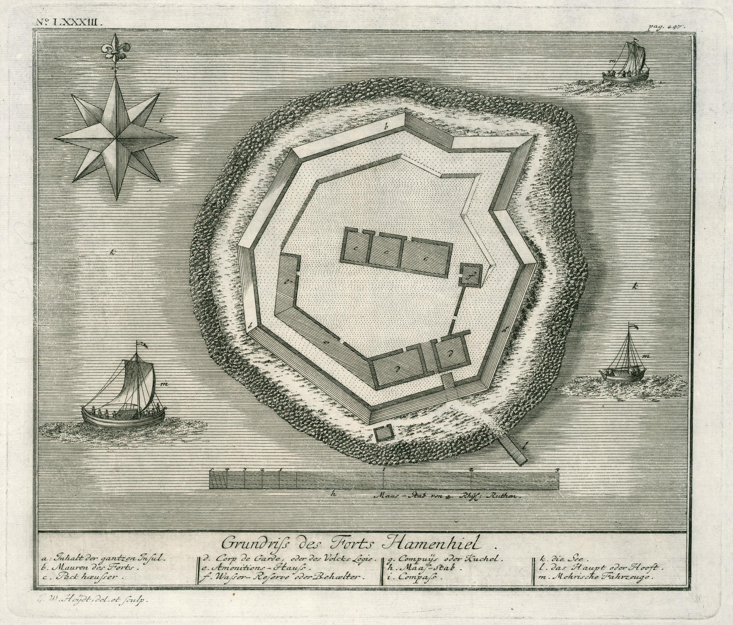
[edit]Nederlands: Plattegrond van fort Hammenhiel
English: Map of Fort Hammenhiel( |
|||||||||||||||||||||
|---|---|---|---|---|---|---|---|---|---|---|---|---|---|---|---|---|---|---|---|---|---|
| Author |
Nederlands: Johann Carl Tetschner (uitgever), Johann Wolfgang Heydt (tekenaar en graveur)
English: Johann Carl Tetschner (publisher), Johann Wolfgang Heydt (draughtsman and engraver) |
||||||||||||||||||||
| Title |
Nederlands: Plattegrond van fort Hammenhiel
English: Map of Fort Hammenhiel |
||||||||||||||||||||
| Description |
Nederlands: Plattegrond van fort Hammenhiel.
Grundriss des Forts Hamenhiel. Linksboven: No: LXXXIII. Rechtsboven: pag. 247. Legenda: a: Inhalt der gantzen Insul. / b. Mauren des Forts. / c. Pack Haeusser. / d. Corp de Garde, oder des Volcks Logis. / e. Amonitions-Hauss. / f. Wasser-Reserve oder Behaelter. / g. Compuijs oder Kuchel. / h. Maas-stab. / i. Compass. / k. die See. / l. das haupt oder Hooft. / m. Mohrische Fahrzeuge.English: Map of Fort Hammenhiel.
Grundriss des Forts Hamenhiel. Top left: No: LXXXIII. Top right: pag. 247. Key: a: Inhalt der gantzen Insul. / b. Mauren des Forts. / c. Pack Haeusser. / d. Corp de Garde, oder des Volcks Logis. / e. Amonitions-Hauss. / f. Wasser-Reserve oder Behaelter. / g. Compuijs oder Kuchel. / h. Maas-stab. / i. Compass. / k. die See. / l. das haupt oder Hooft. / m. Mohrische Fahrzeuge. |
||||||||||||||||||||
| Date | between 1735 and 1744 | ||||||||||||||||||||
| Medium |
Nederlands: koperdruk op papier
English: copperplate printing on paper |
||||||||||||||||||||
| Dimensions | height: 29 cm (11.4 in); width: 24.5 cm (9.6 in) | ||||||||||||||||||||
| Collection |
|
||||||||||||||||||||
| Accession number |
2102 A 7 p. 247 |
||||||||||||||||||||
| Inscriptions |
Grundriss des Forts Hamenhiel
author: J. W. Heijdt, del. et sculp. |
||||||||||||||||||||
| Notes |
English: Subjects: chart / map / plan, fortification, building, ship / vessel, compass / dial, key, Person
Nederlands: Onderwerpen: plattegrond / kaart, vesting, gebouw, schip / vaartuig, kompas / windroos, legenda, Persoon
English: Post: this image is related to a VOC trading post called Hammenhiel |
||||||||||||||||||||
| Source/Photographer |
|
||||||||||||||||||||
| Permission (Reusing this file) |
|
||||||||||||||||||||

| Object location | | View this and other nearby images on: OpenStreetMap |
|---|
File history
Click on a date/time to view the file as it appeared at that time.
| Date/Time | Thumbnail | Dimensions | User | Comment | |
|---|---|---|---|---|---|
| current | 12:27, 10 June 2014 | | 2,400 × 2,049 (1.34 MB) | HuskyBot (talk | contribs) | == {{int:filedesc}} == {{Artwork |title = {{nl|1=Plattegrond van fort Hammenhiel}} {{en|1=Map of Fort Hammenhiel}} |description = {{nl|1=Plattegrond van fort Hammenhiel. ''Grundriss des Forts Hamenhiel''. Lin... |
You cannot overwrite this file.
File usage on Commons
The following 2 pages use this file:
File usage on other wikis
The following other wikis use this file:
- Usage on nl.wikipedia.org
- Usage on www.wikidata.org