File:AMH-6586-NA Map of fort of Baticaloa.jpg
Jump to navigation
Jump to search

Size of this preview: 800 × 563 pixels. Other resolutions: 320 × 225 pixels | 640 × 450 pixels | 1,024 × 720 pixels | 1,280 × 900 pixels | 2,400 × 1,688 pixels.
Original file (2,400 × 1,688 pixels, file size: 511 KB, MIME type: image/jpeg)
Captions
Captions
Add a one-line explanation of what this file represents
Summary[edit]
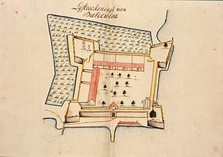
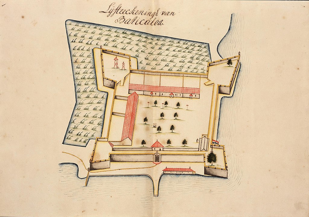
Nederlands: Plattegrond van het fort van Baticaloa
English: Map of fort of Baticaloa( |
||||||||||||||||||||||||
|---|---|---|---|---|---|---|---|---|---|---|---|---|---|---|---|---|---|---|---|---|---|---|---|---|
| Author |
Creator:Livinius Stevenz Creator:Tatik Olivierse Helt Nederlands: Livinius Stevenz (landmeter / kaartenmaker), Tatik Olivierse Helt (landmeter / kaartenmaker)
English: Livinius Stevenz (land surveyor / mapmaker), Tatik Olivierse Helt (land surveyor / mapmaker) |
|||||||||||||||||||||||
| Title |
Nederlands: Plattegrond van het fort van Baticaloa
English: Map of fort of Baticaloa |
|||||||||||||||||||||||
| Description |
Nederlands: Titel catalogus Leupe (NA): Vertoog over den staat der verdedigingswerken bij Negombo, Baticaloa en Trinkonomale met geteekende aanzichten en plattegronden dier werken.
Vierde kaart in een band, op folio 13 / Lijfteeckeningh van Baticaloa..
English: Title in the Leupe catalogue (NA): Vertoog over den staat der verdedigingswerken bij Negombo, Baticaloa en Trinkonomale met geteekende aanzichten en plattegronden dier werken.
Fourth map in a volume on folio 13 / Lijfteeckeningh van Baticaloa.. |
|||||||||||||||||||||||
| Date | 1721 | |||||||||||||||||||||||
| Medium |
Nederlands: ingekleurde tekening op papier
English: coloured drawing on paper |
|||||||||||||||||||||||
| Dimensions | height: 54.5 cm (21.4 in); width: 38 cm (14.9 in) | |||||||||||||||||||||||
| Collection |
|
|||||||||||||||||||||||
| Accession number |
NL-HaNA_4.VELH_344.4 (old number: VELH0344.4) |
|||||||||||||||||||||||
| Inscriptions |
Lijfteeckeningh van Baticaloa
|
|||||||||||||||||||||||
| Notes |
English: Subjects: fortification, building, chart / map / plan
Nederlands: Onderwerpen: vesting, gebouw, plattegrond / kaart
English: Post: this image is related to a VOC trading post called Batticaloa |
|||||||||||||||||||||||
| Source/Photographer |
|
|||||||||||||||||||||||
| Permission (Reusing this file) |
|
|||||||||||||||||||||||

| Object location | | View this and other nearby images on: OpenStreetMap |
|---|
File history
Click on a date/time to view the file as it appeared at that time.
| Date/Time | Thumbnail | Dimensions | User | Comment | |
|---|---|---|---|---|---|
| current | 09:34, 11 June 2014 | | 2,400 × 1,688 (511 KB) | HuskyBot (talk | contribs) | == {{int:filedesc}} == {{Artwork |title = {{nl|1=Plattegrond van het fort van Baticaloa}} {{en|1=Map of fort of Baticaloa}} |description = {{nl|1=Titel catalogus Leupe (NA): ''Vertoog over den staat der verdedi... |
You cannot overwrite this file.
File usage on Commons
The following page uses this file:
File usage on other wikis
The following other wikis use this file:
- Usage on nl.wikipedia.org