File:AMH-6044-NA Map of farmlands in the Batavia area, part nine.jpg

Original file (2,400 × 1,481 pixels, file size: 469 KB, MIME type: image/jpeg)
Captions
Captions
Summary[edit]
| Nederlands: Kaart van landerijen in de omgeving van Batavia, deel negen
English: Map of farmlands in the Batavia area, part nine Bahasa Indonesia: Peta lahan pertanian di wilayah Batavia, bagian sembilan ( |
||||||||||||||||||||||||
|---|---|---|---|---|---|---|---|---|---|---|---|---|---|---|---|---|---|---|---|---|---|---|---|---|
| Author |
Nederlands: Anoniem / Anonymous
English: Anoniem / Anonymous |
|||||||||||||||||||||||
| Title |
Nederlands: Kaart van landerijen in de omgeving van Batavia, deel negen
English: Map of farmlands in the Batavia area, part nine
Bahasa Indonesia: Peta lahan pertanian di wilayah Batavia, bagian sembilan |
|||||||||||||||||||||||
| Description |
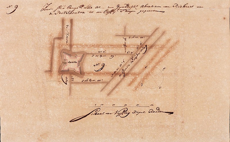
Nederlands: Titel catalogus Leupe (NA): Zeeker stuk Compagnie's land a. ... door Z.E. Abraham van Riebeek aan den post Jacatra tot een coffijthuijn gegeeven.
Het kaartje maakt deel uit van een verzameling van 24 kaartjes en is genummerd no. 9, linksboven en in het midden N.9.. De nummers 11, 20, 21 en 26 ontbreken. Rechtsonder een kompas Z;W;N;O en schaalverdeling Schaal van Vijftig Rhijns: Roeden. In het midden een plattegrond van wegen, grachten en fort, zoals: de Groote Zuyder weg, de heere weg, Jacatra.
English: Title in the Leupe catalogue (NA): Zeeker stuk Compagnie's land a. ... door Z.E. Abraham van Riebeek aan den post Jacatra tot een coffijthuijn gegeeven.
The map is part of a collection of 24 charts and is numbered no. 9, top left and in the centre N.9.. The numbers 11, 20, 21 and 26 are missing. Bottom right a compass Z;W;N;O and a scale Schaal van Vijftig Rhijns: Roeden. In the centre a map of roads, canals and a fort, comprising: de Groote Zuyder weg, de heere weg, Jacatra.
Bahasa Indonesia: Judul dalam katalog Leupe (AN): Zeeker stuk Compagnie's land a. ... door Z.E. Abraham van Riebeek aan den post Jacatra tot een coffijthuijn gegeeven.
Peta tersebut merupakan bagian dari kumpulan 24 peta dan diberi nomor no. 9 di kiri atas dan tengah. Peta nomor 11, 20, 21 dan 26 hilang. Di kanan bawah, terlihat kompas Z;W;N;O dan skala Schaal van Vijftig Rhijns: Roeden. Di tengah peta jalan, kanal dan benteng, terdiri dari: de Groote Zuyder weg, de heere weg, Jacatra. |
|||||||||||||||||||||||
| Date | between 1689 and 1709 | |||||||||||||||||||||||
| Medium |
Nederlands: pen en penseel op papier
English: pen and brush on paper
Bahasa Indonesia: 1pulpen dan sikat di atas kertas |
|||||||||||||||||||||||
| Dimensions | height: 42.5 cm (16.7 in); width: 26.5 cm (10.4 in) | |||||||||||||||||||||||
| Collection |
|
|||||||||||||||||||||||
| Accession number |
NL-HaNA_4.VELH_452.9 (old number: VELH0452_9) |
|||||||||||||||||||||||
| Inscriptions |
Zeeker Stuk Comp Land A.... door Zijn Edelht Abraham van Riebeek aan de Post Jacatra tot een Coffy Thuijn gegeeven
|
|||||||||||||||||||||||
| Notes |
English: Subjects: compass / dial, building, fortification, estate / plantation, chart / map / plan
Nederlands: Onderwerpen: kompas / windroos, gebouw, vesting, landerij / plantage, plattegrond / kaart
English: Fort: this image is related to a VOC fort called fort Jacatra |
|||||||||||||||||||||||
| Source/Photographer |
|
|||||||||||||||||||||||
| Permission (Reusing this file) |
|
|||||||||||||||||||||||

| Object location | | View this and other nearby images on: OpenStreetMap |
|---|
File history
Click on a date/time to view the file as it appeared at that time.
| Date/Time | Thumbnail | Dimensions | User | Comment | |
|---|---|---|---|---|---|
| current | 08:48, 11 June 2014 | | 2,400 × 1,481 (469 KB) | HuskyBot (talk | contribs) | == {{int:filedesc}} == {{Artwork |title = {{nl|1=Kaart van landerijen in de omgeving van Batavia, deel negen}} {{en|1=Map of farmlands in the Batavia area, part nine}} |description = {{nl|1=Titel catalogus Leup... |
You cannot overwrite this file.
File usage on Commons
The following page uses this file: