File:AMH-5427-NA Chart showing part of the 'Bataviasche Groote Rivier', that is, the Ciliwong.jpg

Original file (2,400 × 1,828 pixels, file size: 566 KB, MIME type: image/jpeg)
Captions
Captions
Summary[edit]
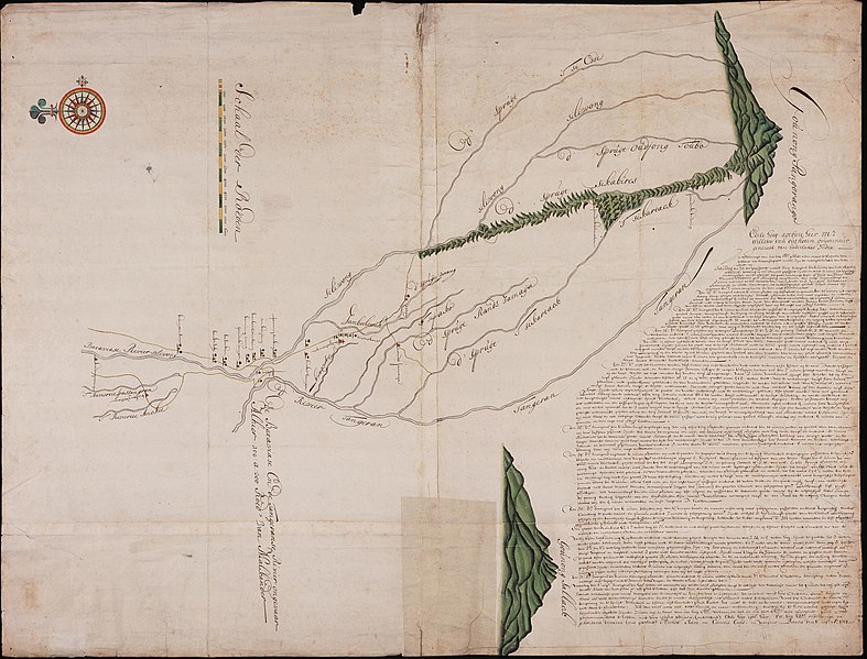
Nederlands: Kaart van een deel van de 'Bataviasche Groote Rivier' ofwel de Ciliwong
English: Chart showing part of the 'Bataviasche Groote Rivier', that is, the Ciliwong( |
||||||||||||||||||||||||
|---|---|---|---|---|---|---|---|---|---|---|---|---|---|---|---|---|---|---|---|---|---|---|---|---|
| Author |
Creator:Cornelis Coops Creator:Michiel Ram Nederlands: Cornelis Coops (opdrachtgever), Michiel Ram (opdrachtgever)
English: Cornelis Coops (patron), Michiel Ram (patron) |
|||||||||||||||||||||||
| Title |
Nederlands: Kaart van een deel van de 'Bataviasche Groote Rivier' ofwel de Ciliwong
English: Chart showing part of the 'Bataviasche Groote Rivier', that is, the Ciliwong |
|||||||||||||||||||||||
| Description |
Nederlands: Titel catalogus Leupe (NA): Kaart van het land tusschen Koedongwiringin en Gounong Pangorango, tot het onderzoeken van den staat der Bataviasche Groote Rivier.
Notities verso: No. 25. de bergen Pangerano en Salak, buijten Batavia / 623 [met vette cijfers gestempeld op een etiketje] / 56 [geschreven op een klein rond etiketje]. Weergegeven is het gebied rondom Bogor (ofwel Buitenzorg, deze naam staat niet als zodanig op de kaart vermeld) waar de Ciliwong en de Tangerangse Rivier dicht bijeen komen.English: Title in the Leupe catalogue (NA): Kaart van het land tusschen Koedongwiringin en Gounong Pangorango, tot het onderzoeken van den staat der Bataviasche Groote Rivier.
Notes on reverse: No. 25. de bergen Pangerano en Salak, buijten Batavia / 623 [stamped in bold on a small label] / 56 [inscribed on a small round label]. Shown here is the area surrounding Bogor (otherwise known as Buitenzorg, although this name is not featured as such on the map) where the Ciliwong and Tangerang rivers almost meet. |
|||||||||||||||||||||||
| Date | 1701 | |||||||||||||||||||||||
| Medium |
Nederlands: ingekleurde tekening op papier
English: coloured drawing on paper |
|||||||||||||||||||||||
| Dimensions | height: 82 cm (32.2 in); width: 62.5 cm (24.6 in) | |||||||||||||||||||||||
| Collection |
|
|||||||||||||||||||||||
| Accession number |
NL-HaNA_4.VEL_1168 (old number: VEL1168) |
|||||||||||||||||||||||
| Inscriptions |
Edele hoog agtbare m: Willem van Outhoorn gouverneur generaal van nederlands India [...]
author: Michiel Ram en Cornelis Coops, Batavia den 6den Aug Ao 1701 |
|||||||||||||||||||||||
| Notes |
English: Subjects: chart / map / plan, compass / dial, flora
Nederlands: Onderwerpen: plattegrond / kaart, kompas / windroos, flora
English: Post: this image is related to a VOC trading post called Bogor |
|||||||||||||||||||||||
| Source/Photographer |
|
|||||||||||||||||||||||
| Permission (Reusing this file) |
|
|||||||||||||||||||||||

| Object location | | View this and other nearby images on: OpenStreetMap |
|---|
File history
Click on a date/time to view the file as it appeared at that time.
| Date/Time | Thumbnail | Dimensions | User | Comment | |
|---|---|---|---|---|---|
| current | 18:18, 10 June 2014 | | 2,400 × 1,828 (566 KB) | HuskyBot (talk | contribs) | == {{int:filedesc}} == {{Artwork |title = {{nl|1=Kaart van een deel van de 'Bataviasche Groote Rivier' ofwel de Ciliwong}} {{en|1=Chart showing part of the 'Bataviasche Groote Rivier', that is, the Ciliwong}} |descr... |
You cannot overwrite this file.
File usage on Commons
The following page uses this file: