File:AMH-4728-NA Fort Hollandia on Lonthor.jpg
Original file (2,400 × 1,871 pixels, file size: 535 KB, MIME type: image/jpeg)
Captions
Captions
Summary[edit]
| Nederlands: Fort Hollandia op Lonthor
English: Fort Hollandia on Lonthor Bahasa Indonesia: Benteng Hollandia di Lonthor( |
||||||||||||||||||||||||
|---|---|---|---|---|---|---|---|---|---|---|---|---|---|---|---|---|---|---|---|---|---|---|---|---|
| Author |
Nederlands: Anoniem / Anonymous
English: Anoniem / Anonymous |
|||||||||||||||||||||||
| Title |
Nederlands: Fort Hollandia op Lonthor
English: Fort Hollandia on Lonthor
Bahasa Indonesia: Benteng Hollandia di Lonthor |
|||||||||||||||||||||||
| Description |
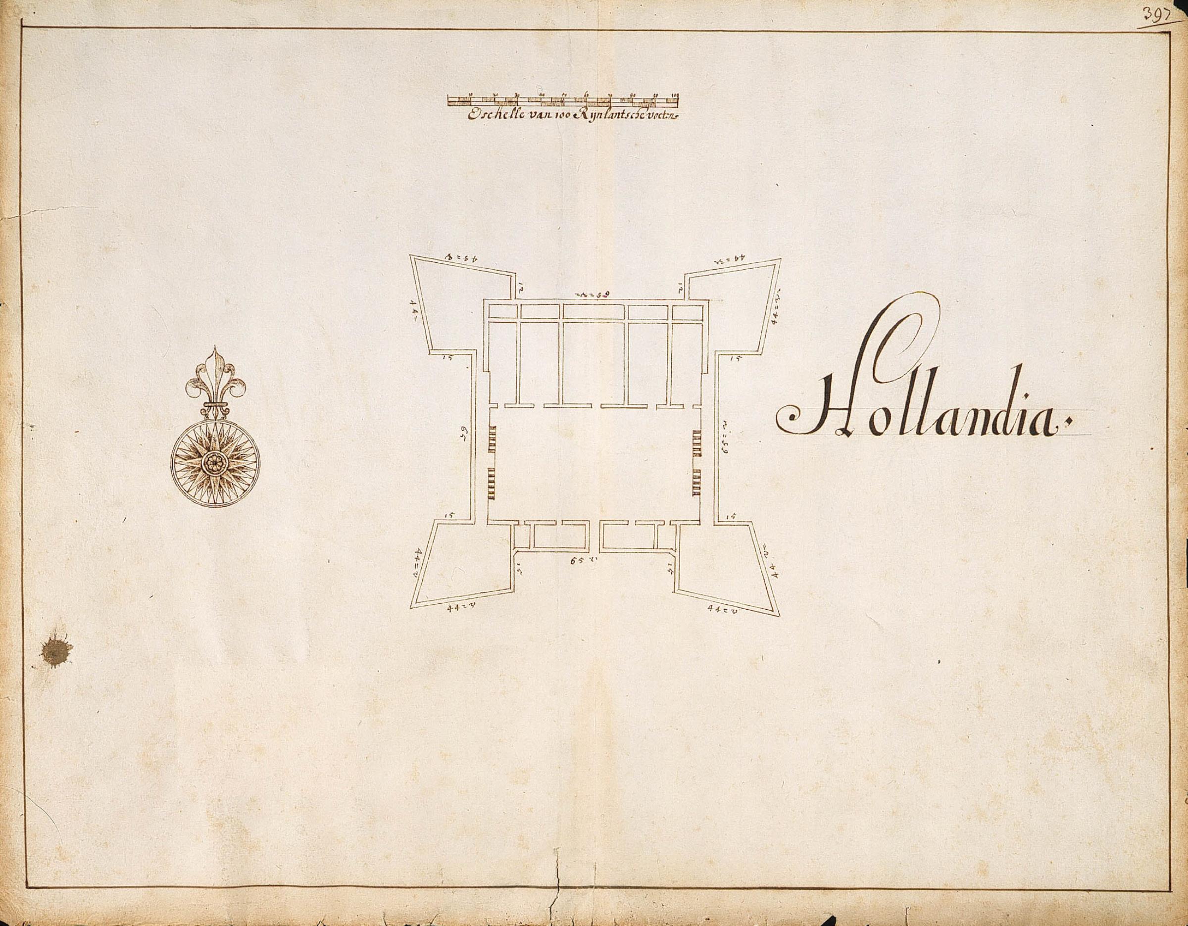
Nederlands: Titel catalogus Leupe (NA): Plan van het fort Hollandia.
Behoort bij het rapport van Arnold de Vlamingh van Outshoorn. Rechts boven genummerd: 397. De randen zijn gerafeld Notities verso: 397 [moet het folionummer in de band OBP zijn] / 664 h:i.English: According to the Leupe catalogue (NA), the original title reads: Plan van het fort Hollandia.
Belongs with the report of Arnold de Vlamingh van Outshoorn. Numbered top right: 397. The edges are frayed. Notes on reverse: 397 [must refer to the folio number in the OBP volume]/ 664 h:i.Bahasa Indonesia: Menurut katalog Leupe (NA), judul aslinya berbunyi: Plan van het fort Hollandia.
Berasal dari laporan milik Arnold de Vlamingh van Outshoorn. Dinomori pada kanan atas: 397. Ujung-ujungnya terkelupas. Catatan di belakang: 397 [seharusnya mengacu pada nomor folio dalam volume OBP]/ 664 h:i. |
|||||||||||||||||||||||
| Date | circa 1651 | |||||||||||||||||||||||
| Medium |
Nederlands: pen op papier
English: pen on paper
Bahasa Indonesia: pulpen di atas kertas |
|||||||||||||||||||||||
| Dimensions | height: 41.5 cm (16.3 in); width: 33 cm (12.9 in) | |||||||||||||||||||||||
| Collection |
|
|||||||||||||||||||||||
| Accession number |
NL-HaNA_4.VEL_1365 (old number: VEL1365) |
|||||||||||||||||||||||
| Inscriptions |
Hollandia
|
|||||||||||||||||||||||
| Notes |
English: Subjects: chart / map / plan, compass / dial, fortification
Nederlands: Onderwerpen: plattegrond / kaart, kompas / windroos, vesting
English: Fort: this image is related to a VOC fort called fort Hollandia |
|||||||||||||||||||||||
| Source/Photographer |
|
|||||||||||||||||||||||
| Permission (Reusing this file) |
|
|||||||||||||||||||||||

| Object location | | View this and other nearby images on: OpenStreetMap |
|---|
File history
Click on a date/time to view the file as it appeared at that time.
| Date/Time | Thumbnail | Dimensions | User | Comment | |
|---|---|---|---|---|---|
| current | 17:09, 10 June 2014 | | 2,400 × 1,871 (535 KB) | HuskyBot (talk | contribs) | == {{int:filedesc}} == {{Artwork |title = {{nl|1=Fort Hollandia op Lonthor}} {{en|1=Fort Hollandia on Lonthor}} |description = {{nl|1=Titel catalogus Leupe (NA): ''Plan van het fort Hollandia''. Behoort bij he... |
You cannot overwrite this file.
File usage on Commons
The following page uses this file: