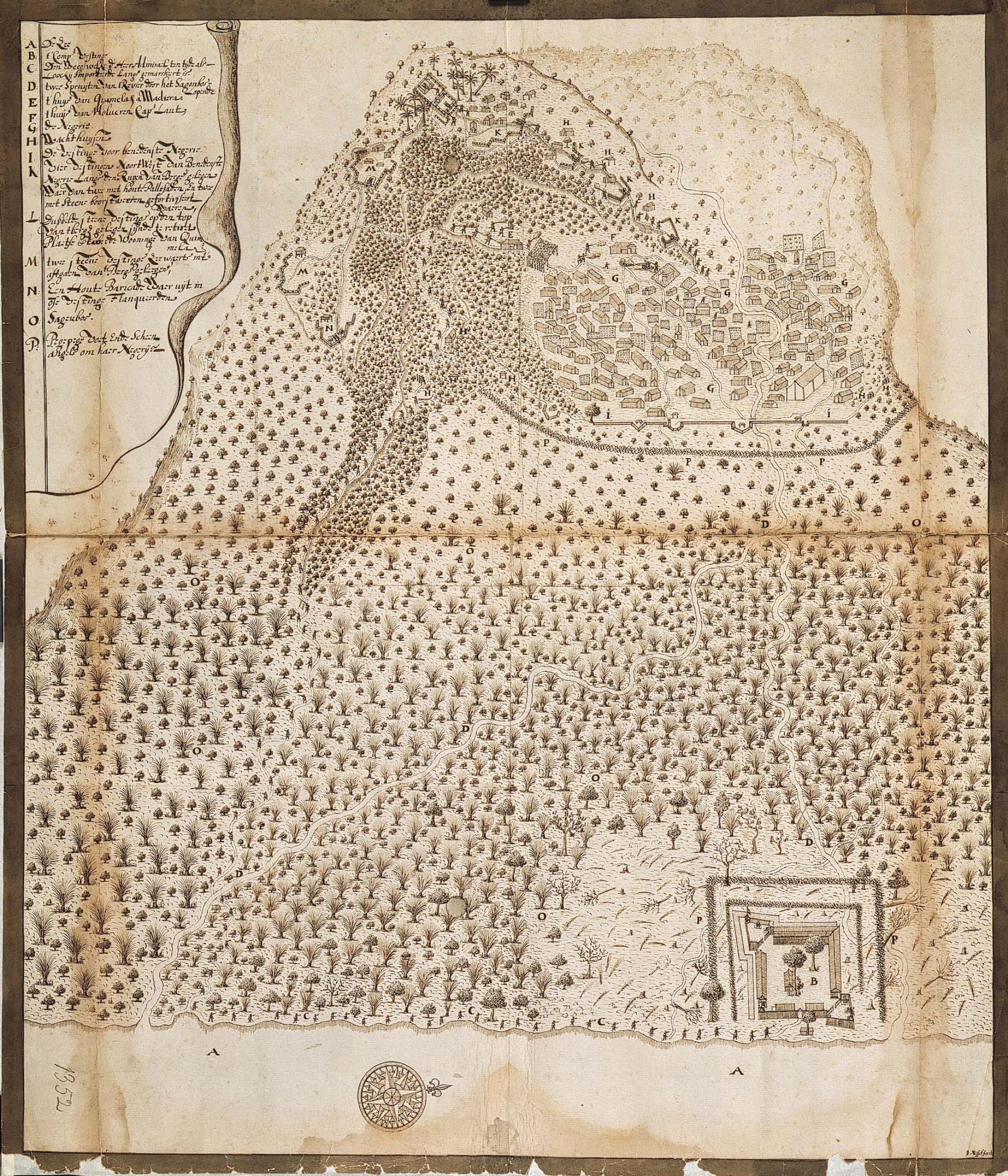
File:AMH-4718-NA The fort at Loki.jpg
Original file (2,058 × 2,400 pixels, file size: 1.36 MB, MIME type: image/jpeg)
Captions
Captions
Summary[edit]
| Nederlands: Het fort te Loki
English: The fort at Loki ( |
||||||||||||||||||||||||
|---|---|---|---|---|---|---|---|---|---|---|---|---|---|---|---|---|---|---|---|---|---|---|---|---|
| Author |
Nederlands: Johannes (van) Nessel (landmeter / kaartenmaker)
English: Johannes (van) Nessel (land surveyor / mapmaker) |
|||||||||||||||||||||||
| Title |
Nederlands: Het fort te Loki
English: The fort at Loki |
|||||||||||||||||||||||
| Description |
Nederlands: Titel catalogus Leupe (NA): Afbeelding van de negory Locki, 's Comp:s vastigheid, des vyands weren en optogt onzer troepen enz..
Behoort bij het rapport van Arnold de Vlamingh van Outshoorn. Drie randen van de kaart zijn beplakt met stroken rijstpapier. Notities verso: Behoort by den brief van A: de Vl: v: Oudshoorn van den 20 octo 1652 fol: 676 / 661 a.English: According to the Leupe catalogue (NA), the original title reads: Afbeelding van de negory Locki, 's Comp:s vastigheid, des vyands weren en optogt onzer troepen enz..
Belongs with the report by Arnold de Vlamingh van Outshoorn. The edges of the map have been reinforced with strips of rice paper. Notes on reverse: Behoort by den brief van A: de Vl: v: Oudshoorn van den 20 octo 1652 fol: 676 / 661 a. |
|||||||||||||||||||||||
| Date | circa 1652 | |||||||||||||||||||||||
| Medium |
Nederlands: pen op papier
English: pen on paper |
|||||||||||||||||||||||
| Dimensions | height: 52.5 cm (20.6 in); width: 60.5 cm (23.8 in) | |||||||||||||||||||||||
| Collection |
|
|||||||||||||||||||||||
| Accession number |
NL-HaNA_4.VEL_1352 (old number: VEL1352) |
|||||||||||||||||||||||
| Inscriptions |
-
author: J. Nessel fecit |
|||||||||||||||||||||||
| Notes |
English: Subjects: key, battle / taking / war (fight), compass / dial, flora, fortification, banderole / cartouche / ornamentation
Nederlands: Onderwerpen: legenda, veldslag / oorlog (strijd) / inname, kompas / windroos, flora, vesting, banderol / cartouche / versiering
English: Post: this image is related to a VOC trading post called Loki |
|||||||||||||||||||||||
| Source/Photographer |
|
|||||||||||||||||||||||
| Permission (Reusing this file) |
|
|||||||||||||||||||||||

| Object location | | View this and other nearby images on: OpenStreetMap |
|---|
File history
Click on a date/time to view the file as it appeared at that time.
| Date/Time | Thumbnail | Dimensions | User | Comment | |
|---|---|---|---|---|---|
| current | 17:07, 10 June 2014 | | 2,058 × 2,400 (1.36 MB) | HuskyBot (talk | contribs) | == {{int:filedesc}} == {{Artwork |title = {{nl|1=Het fort te Loki}} {{en|1=The fort at Loki}} |description = {{nl|1=Titel catalogus Leupe (NA): ''Afbeelding van de negory Locki, 's Comp:s vastigheid, des vyands... |
You cannot overwrite this file.
File usage on Commons
The following page uses this file: