File:AMH-4717-NA The bay and surrounding mountains at Assahoedi.jpg

Original file (2,400 × 2,242 pixels, file size: 1.09 MB, MIME type: image/jpeg)
Captions
Captions
Summary[edit]
| Nederlands: De baai en het daaraan gelegen gebergte bij Assahoedi
English: The bay and surrounding mountains at Assahoedi Bahasa Indonesia: Teluk dan pegunungan sekitarnya di Assahoedi( |
||||||||||||||||||||||||
|---|---|---|---|---|---|---|---|---|---|---|---|---|---|---|---|---|---|---|---|---|---|---|---|---|
| Author |
Nederlands: Anoniem / Anonymous
English: Anoniem / Anonymous |
|||||||||||||||||||||||
| Title |
Nederlands: De baai en het daaraan gelegen gebergte bij Assahoedi
English: The bay and surrounding mountains at Assahoedi
Bahasa Indonesia: Teluk dan pegunungan sekitarnya di Assahoedi |
|||||||||||||||||||||||
| Description |
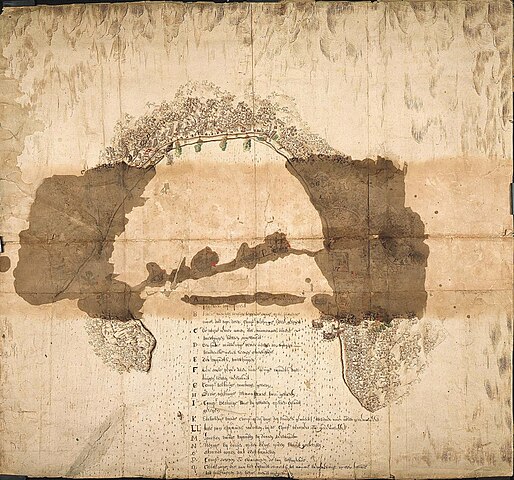
Nederlands: Titel catalogus Leupe (NA): Afbeelding van de baay en het daaraan gelegen gebergte, met des vyands werken enz. van Assahoedi.
Behoort bij het rapport van Arnold de Vlamingh van Outshoorn. Bij legendaletter I staat de Nederlandse vestiging aangeduid. Legenda: A-Q De achterkant is beplakt met bruin papier. De afbeelding op de kaart is voor het grootste gedeelte slecht te zien door grote donkere vlekken op die afbeelding, de legenda is echter goed leesbaar behalve de letter A. Notities verso: 662 [met vette cijfers gestempeld op een etiketje] / No 113 [met daarvoor nog twee onleesbare woordjes, alles in rood potlood].English: According to the Leupe catalogue (NA), the original title reads: Afbeelding van de baay en het daaraan gelegen gebergte, met des vyands werken enz. van Assahoedi.
Belongs with the report by Arnold de Vlamingh van Outshoorn. The Dutch fort is indicated against number I in the key. Key: A-Q The reverse is stuck down with brown paper. The representation on the map is for the most part difficult to discern due to large brown stains on the map. However the key is easily legible except under the letter A. Notes on reverse: 662 [stamped on a small label in bold] / No 113 [preceded by two illegible words, all in red pencil].Bahasa Indonesia: Menurut katalog Leupe (NA), judul aslinya berbunyi: Afbeelding van de baay en het daaraan gelegen gebergte, met des vyands werken enz. van Assahoedi.
Berasal dari laporan milik Arnold de Vlamingh van Outshoorn. Benteng Belanda ditunjukkan pada nomor I di kunci. Kunci: A-Q Halaman belakang ditempel dengan kertas cokelat. Representasi pada peta sebagian besar sulit untuk dilihat karena noda cokelat besar pada peta. Namun kuncinya mudah terbaca kecuali di bawah huruf A. Catatan di belakang: 662 [dicetak tebal pada label kecil] / No 113 [didahului oleh dua kata yang tidak terbaca, semuanya dengan pensil merah]. |
|||||||||||||||||||||||
| Date | circa 1655 | |||||||||||||||||||||||
| Medium |
Nederlands: ingekleurde tekening op papier
English: coloured drawing on paper
Bahasa Indonesia: gambar berwarna di atas kertas |
|||||||||||||||||||||||
| Dimensions | height: 69.5 cm (27.3 in); width: 64.5 cm (25.3 in) | |||||||||||||||||||||||
| Collection |
|
|||||||||||||||||||||||
| Accession number |
NL-HaNA_4.VEL_1351 (old number: VEL1351) |
|||||||||||||||||||||||
| Inscriptions |
-
|
|||||||||||||||||||||||
| Notes |
English: Subjects: key, ship / vessel, chart / map / plan, fortification
Nederlands: Onderwerpen: legenda, schip / vaartuig, plattegrond / kaart, vesting
English: Post: this image is related to a VOC trading post called Asaudi |
|||||||||||||||||||||||
| Source/Photographer |
|
|||||||||||||||||||||||
| Permission (Reusing this file) |
|
|||||||||||||||||||||||

| Object location | | View this and other nearby images on: OpenStreetMap |
|---|
File history
Click on a date/time to view the file as it appeared at that time.
| Date/Time | Thumbnail | Dimensions | User | Comment | |
|---|---|---|---|---|---|
| current | 17:07, 10 June 2014 | | 2,400 × 2,242 (1.09 MB) | HuskyBot (talk | contribs) | == {{int:filedesc}} == {{Artwork |title = {{nl|1=De baai en het daaraan gelegen gebergte bij Assahoedi}} {{en|1=The bay and surrounding mountains at Assahoedi}} |description = {{nl|1=Titel catalogus Leupe (NA):... |
You cannot overwrite this file.
File usage on Commons
The following page uses this file: