File:AMH-4193-NA Map of Negombo fort.jpg
Original file (2,400 × 1,664 pixels, file size: 550 KB, MIME type: image/jpeg)
Captions
Captions
Summary[edit]
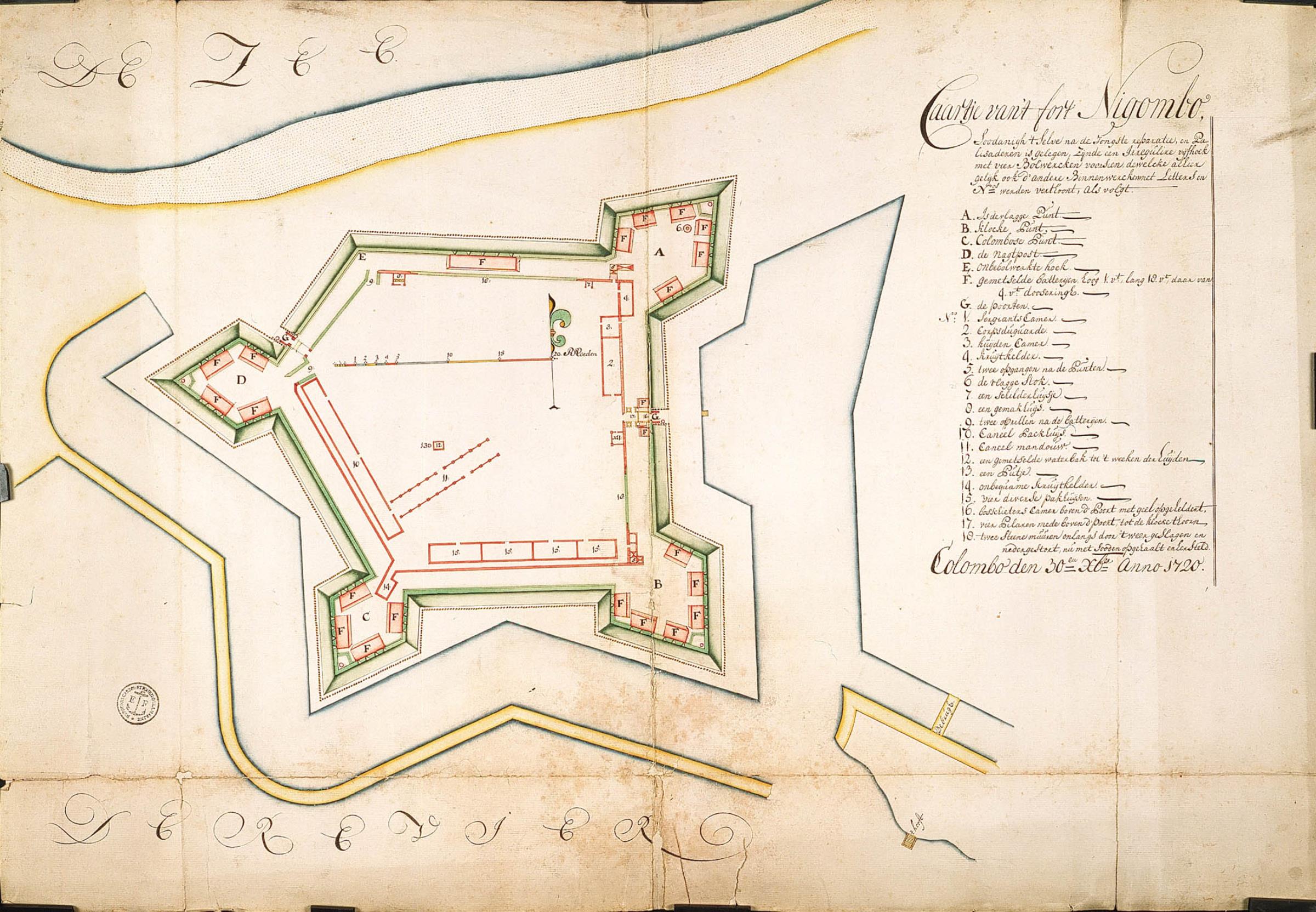
Nederlands: Kaart van het fort Nigombo
English: Map of Negombo fort( |
||||||||||||||||||||||||
|---|---|---|---|---|---|---|---|---|---|---|---|---|---|---|---|---|---|---|---|---|---|---|---|---|
| Author |
Nederlands: Anoniem / Anonymous
English: Anoniem / Anonymous |
|||||||||||||||||||||||
| Title |
Nederlands: Kaart van het fort Nigombo
English: Map of Negombo fort |
|||||||||||||||||||||||
| Description |
Nederlands: Titel catalogus Leupe (NA): Caartje van 't fort Nigombo, soodanigh 't selve na de jongste reparatie en palissaderen is gelegen, zynde een irriguliere Vyfhoek met vier bolwerken voorsien enz..
Notities verso: Kaart van het fort Negombo, 1720. [Blauw etiket] nr. 8 Plan van Negombo. [Etiket gedrukt] nr. 543. Legenda: A-G; 1-18English: According to Leupe catalogue (NA), the original title reads: Caartje van 't fort Nigombo, soodanigh 't selve na de jongste reparatie en palissaderen is gelegen, zynde een irriguliere Vyfhoek met vier bolwerken voorsien enz..
Notes on reverse: Kaart van het fort Negombo, 1720. [Blauw etiket] nr. 8 Plan van Negombo. [Etiket gedrukt] nr. 543. Key: A-G; 1-18 |
|||||||||||||||||||||||
| Date | 30 October 1720 | |||||||||||||||||||||||
| Medium |
Nederlands: ingekleurde tekening op papier
English: coloured drawing on paper |
|||||||||||||||||||||||
| Dimensions | height: 73 cm (28.7 in); width: 51 cm (20 in) | |||||||||||||||||||||||
| Collection |
|
|||||||||||||||||||||||
| Accession number |
NL-HaNA_4.VEL_990 (old number: VEL0990) |
|||||||||||||||||||||||
| Inscriptions |
Caartje van 't fort Nigombo, soodanigh 't selve na de jongste reparatie en palissaderen is gelegen, zynde een irriguliere Vyfhoek met vier bolwerken voorsien dewelcke alhier gelijk oock d'andere Binnenwercken met letters en Nrs werden verthoont, als volgt. |
|||||||||||||||||||||||
| Notes |
English: Subjects: chart / map / plan, fortification, key
Nederlands: Onderwerpen: plattegrond / kaart, vesting, legenda
English: Post: this image is related to a VOC trading post called Negombo |
|||||||||||||||||||||||
| Source/Photographer |
|
|||||||||||||||||||||||
| Permission (Reusing this file) |
|
|||||||||||||||||||||||

| Object location | | View this and other nearby images on: OpenStreetMap |
|---|
File history
Click on a date/time to view the file as it appeared at that time.
| Date/Time | Thumbnail | Dimensions | User | Comment | |
|---|---|---|---|---|---|
| current | 16:17, 10 June 2014 | | 2,400 × 1,664 (550 KB) | HuskyBot (talk | contribs) | == {{int:filedesc}} == {{Artwork |title = {{nl|1=Kaart van het fort Nigombo}} {{en|1=Map of Negombo fort}} |description = {{nl|1=Titel catalogus Leupe (NA): ''Caartje van 't fort Nigombo, soodanigh 't selve na... |
You cannot overwrite this file.
File usage on Commons
The following page uses this file:
File usage on other wikis
The following other wikis use this file:
- Usage on nl.wikipedia.org