File:AMH-2650-NA Map of the beaches to the west and east of the castle at Batavia.jpg

Original file (2,400 × 710 pixels, file size: 219 KB, MIME type: image/jpeg)
Captions
Captions
Summary[edit]
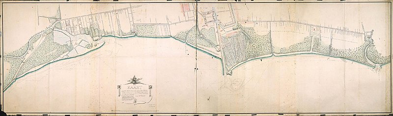
| Nederlands: Kaart van de stranden ten westen en oosten van kasteel Batavia
English: Map of the beaches to the west and east of the castle at Batavia Bahasa Indonesia: Peta pantai di sebelah barat dan timur benteng di Batavia ( |
||||||||||||||||||||||||
|---|---|---|---|---|---|---|---|---|---|---|---|---|---|---|---|---|---|---|---|---|---|---|---|---|
| Author |
Nederlands: Carl Friedrich Reimer (gewerkt naar), W:m. O. Burgemeestre (landmeter / kaartenmaker)
English: Carl Friedrich Reimer (copied after), W:m. O. Burgemeestre (land surveyor / mapmaker) |
|||||||||||||||||||||||
| Title |
Nederlands: Kaart van de stranden ten westen en oosten van kasteel Batavia
English: Map of the beaches to the west and east of the castle at Batavia
Bahasa Indonesia: Peta pantai di sebelah barat dan timur benteng di Batavia |
|||||||||||||||||||||||
| Description |
Nederlands: Titel in catalogus Leupe (NA): Kaart van de Stranden en gesamentlyke situatie der bewesten en beoosten 't Kasteel Batavia gelegene landen en tuynen, van den Mond der Rivier Anké af tot voorby den Mond der rivier van Antsjol en Slingerland
Kopie naar de kaart van C.F. Reimer. Topografische namen vermeld op deze kaart: Batterij Bottelier, Rivier van Antsjol, Batterij Zeelucht, Batterij Slingerland, Rotterdamer Poort, Fort Antsjol, Tandjong Priok, 't Kasteel, Saphier, Parel, Diamant, Robijn, Cuylenburg, Zeeburg, Groningen, Kampen, Overijsel, Batterij van Ploederhuijsie [?], Waterkasteel, Dieren, Batterij de Fluyt, Rivier Ankee, Grote Rivier.English: According to the catalogue Leupe (NA), the original title reads: Kaart van de Stranden en gesamentlyke situatie der bewesten en beoosten 't Kasteel Batavia gelegene landen en tuynen, van den Mond der Rivier Anké af tot voorby den Mond der rivier van Antsjol en Slingerland
This is a copy based on the map by C.F. Reimer. Topographical names mentioned: Batterij Bottelier, Rivier van Antsjol, Batterij Zeelucht, Batterij Slingerland, Rotterdamer Poort, Fort Antsjol, Tandjong Priok, 't Kasteel, Saphier, Parel, Diamant, Robijn, Cuylenburg, Zeeburg, Groningen, Kampen, Overijsel, Batterij van Ploederhuijsie [?], Waterkasteel, Dieren, Batterij de Fluyt, Rivier Ankee, Grote Rivier.Bahasa Indonesia: Menurut katalog Leupe (NA), judul aslinya berbunyi: Kaart van de Stranden en gesamentlyke situatie der bewesten en beoosten 't Kasteel Batavia gelegene landen en tuynen, van den Mond der Rivier Anké af tot voorby den Mond der rivier van Antsjol en Slingerland
Ini adalah salinan dari peta yang dibuat oleh C.F. Reimer. Nama-nama topografi yang disebutkan: Batterij Bottelier, Rivier van Antsjol, Batterij Zeelucht, Batterij Slingerland, Rotterdamer Poort, Fort Antsjol, Tandjong Priok, 't Kasteel, Saphier, Parel, Diamant, Robijn, Cuylenburg, Zeeburg, Groningen, Kampen, Overijsel, Batterij van Ploederhuijsie [?], Waterkasteel, Dieren, Batterij de Fluyt, Rivier Ankee, Grote Rivier. |
|||||||||||||||||||||||
| Date | circa 1788 | |||||||||||||||||||||||
| Medium |
Nederlands: ingekleurde tekening op papier
English: coloured drawing on paper
Bahasa Indonesia: gambar berwarna di atas kertas |
|||||||||||||||||||||||
| Dimensions | height: 3,520 mm (11.54 ft); width: 1,030 mm (40.55 in) | |||||||||||||||||||||||
| Collection |
|
|||||||||||||||||||||||
| Accession number |
NL-HaNA_4.VEL_421 (old number: VEL0421) |
|||||||||||||||||||||||
| Inscriptions |
No II Kaart van de stranden en gesamentlyke situatie, der beoosten en bewesten 't Kasteel Batavia, geleegene landen en Tuynen, van den Mond der Riviere Ankee af tot voorby den Mond der rivier van Antsjol en Slingerland: voor sooverre derselver Gelegenheid ten opzigte der zeekerheid deeser Hoofdplaats en tot het opmaaken van een Ontwerp van welbegreepene Defensie, daarvan kan in aanmerking komen, Ten welken Eynde ook deese Stranden en Rivieren doorgaans gepeyld en alles daartoe dienende uitvoerig is gemete en in Kaart gebragt. Op Ordre van Hun Hoog Edelheeden in den Jaare MDCCLXXXVIII door C.F. Reimer / in het Marineschool gecopieerd na het origineele van den Heer C.F. Reimer door Wm. O. Burgemeestre author: in het Marineschool gecopieerd na het origineele van den Heer C.F. Reimer door W:m. O. Burgemeestre |
|||||||||||||||||||||||
| Notes |
English: Subjects: chart / map / plan, church / parsonage, fortification, building, garden / ornamental garden, anchorage / pier / harbour, pagoda / temple, mosque, banderole / cartouche / ornamentation
Nederlands: Onderwerpen: plattegrond / kaart, kerk / pastorie, vesting, gebouw, tuin / siertuin, rede / haven / pier, pagode / tempel, moskee, banderol / cartouche / versiering
English: Post: this image is related to a VOC trading post called Jakarta |
|||||||||||||||||||||||
| Source/Photographer |
|
|||||||||||||||||||||||
| Permission (Reusing this file) |
|
|||||||||||||||||||||||

| Object location | | View this and other nearby images on: OpenStreetMap |
|---|
File history
Click on a date/time to view the file as it appeared at that time.
| Date/Time | Thumbnail | Dimensions | User | Comment | |
|---|---|---|---|---|---|
| current | 16:15, 10 June 2014 | 2,400 × 710 (219 KB) | HuskyBot (talk | contribs) | == {{int:filedesc}} == {{Artwork |title = {{nl|1=Kaart van de stranden ten westen en oosten van kasteel Batavia}} {{en|1=Map of the beaches to the west and east of the castle at Batavia}} |description = {{nl|1=... |
You cannot overwrite this file.
File usage on Commons
The following page uses this file:
File usage on other wikis
The following other wikis use this file:
- Usage on nl.wikipedia.org