File:AMH-2587-NA Plan to reduce the fort at Cananoor, with some changes.jpg

Original file (2,400 × 1,554 pixels, file size: 355 KB, MIME type: image/jpeg)
Captions
Captions
Summary[edit]
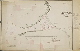
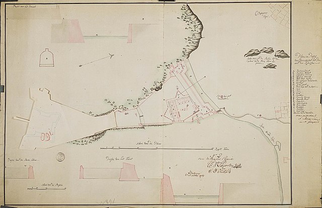
Nederlands: Plan ter verkleining van het fort van Cananoor met enige veranderingen
English: Plan to reduce the fort at Cananoor, with some changes( |
||||||||||||||||||||||||
|---|---|---|---|---|---|---|---|---|---|---|---|---|---|---|---|---|---|---|---|---|---|---|---|---|
| Author |
Creator:W.B.E. Paravicini di Capelli Creator:J.L. Guyard Nederlands: C.P. Keller (landmeter / kaartenmaker), C.A. Luepken (landmeter / kaartenmaker), W.B.E. Paravicini di Capelli (gewerkt naar), J.L. Guyard (gewerkt naar)
English: C.P. Keller (land surveyor / mapmaker), C.A. Luepken (land surveyor / mapmaker), W.B.E. Paravicini di Capelli (copied after), J.L. Guyard (copied after) |
|||||||||||||||||||||||
| Title |
Nederlands: Plan ter verkleining van het fort van Cananoor met enige veranderingen
English: Plan to reduce the fort at Cananoor, with some changes |
|||||||||||||||||||||||
| Description |
Nederlands: Titel catalogus Leupe (NA): Plan en Project als voren, met eenige veranderingen, hier wordt bedoeld de titel van VEL0890: Plan en Project ter reductie van Cananoor, met eenige veranderingen.
Deze kaart heeft in het midden een flap die omhoog kan, zie VEL0891flap. Inzetkaart: Plan of papiotte van de oude situatie van fort voor de verbouwing tot sterreschans. Plankaarten van de bestaande en nieuwe ontworpen fortificatiewerken van Cananoor, door N. Paravicini en N. Guijard, gekopieerd door C.P. von Luepken en C.P. Keller. Legenda's: Plan aanleg sterreschans: A-W; 6-8. Notities verso: [Blauw ODG-etiket] nr. 11 Plan en Profil van Cananoor, reg. nr. 6, deel 1; folio 28; nr. 49; 230; [Gedrukt Etiket] nr. 501. Topografische namen vermeld op deze kaart: Bastioen Zelant, Bastioen Hollant.English: According to catalogue Leupe (NA) the original title reads as: Plan en Project als voren, met eenige veranderingen, referring to the title of VEL0890: Plan en Project ter reductie van Cananoor, met eenige veranderingen.
This chart has a flap in the centre that may be lifted up, see VEL0891flap. Inset: Plan or papiotte of the old situation of the fort before it was rebuilt in the shape of a star. Plans of the existing and newly-designed fortifications of Cananoor by N. Paravicini and N. Guijard, copied by C.P. von Luepken and C.P. Keller. Key: Plan for the construction of the star fort: A-W; 6-8. Notes on reverse: [Blue ODG-label] nr. 11 Plan en Profil van Cananoor, reg. nr. 6, deel 1; folio 28; nr. 49; 230; [Prindted Label] nr. 501. Topographical names mentioned on this map: Bastioen Zelant, Bastioen Hollant. |
|||||||||||||||||||||||
| Date | 1 October 1767 | |||||||||||||||||||||||
| Medium |
Nederlands: ingekleurde tekening op papier
English: coloured drawing on paper |
|||||||||||||||||||||||
| Dimensions | height: 85 cm (33.4 in); width: 56 cm (22 in) | |||||||||||||||||||||||
| Collection |
|
|||||||||||||||||||||||
| Accession number |
NL-HaNA_4.VEL_891 (old number: VEL0891) |
|||||||||||||||||||||||
| Inscriptions |
Plan en Profil van Cananoor met het Project van Reductie
author: C.A. Luepken, C.P. Keller (N.2 Voor de Exacte Copie) / was geteekend N. Paravicini en N. Guijard |
|||||||||||||||||||||||
| Notes |
English: Subjects: chart / map / plan, fortification, hospital / lazaret, garden / ornamental garden, flora, warehouse, anchorage / pier / harbour, cross-section / profile, bazaar / market, powder magazine / powder mill, key
Nederlands: Onderwerpen: plattegrond / kaart, vesting, ziekenhuis / lazaret, tuin / siertuin, flora, pakhuis, rede / haven / pier, doorsnede / profiel, bazaar / markt, kruithuis / kruitmolen, legenda
English: Post: this image is related to a VOC trading post called Cannanore |
|||||||||||||||||||||||
| Source/Photographer |
|
|||||||||||||||||||||||
| Permission (Reusing this file) |
|
|||||||||||||||||||||||

| Object location | | View this and other nearby images on: OpenStreetMap |
|---|
File history
Click on a date/time to view the file as it appeared at that time.
| Date/Time | Thumbnail | Dimensions | User | Comment | |
|---|---|---|---|---|---|
| current | 16:01, 10 June 2014 | | 2,400 × 1,554 (355 KB) | HuskyBot (talk | contribs) | == {{int:filedesc}} == {{Artwork |title = {{nl|1=Plan ter verkleining van het fort van Cananoor met enige veranderingen}} {{en|1=Plan to reduce the fort at Cananoor, with some changes}} |description = {{nl|1=Ti... |
You cannot overwrite this file.
File usage on Commons
The following page uses this file: