File:AMH-2585-NA Plan to reduce the fort at Cananoor.jpg
Original file (1,859 × 2,400 pixels, file size: 670 KB, MIME type: image/jpeg)
Captions
Captions
Summary[edit]
| Nederlands: Plan ter verkleining van het fort van Cananoor
English: Plan to reduce the fort at Cananoor Bahasa Indonesia: Rencana untuk mengurangi benteng di Cananoor( |
||||||||||||||||||||||||
|---|---|---|---|---|---|---|---|---|---|---|---|---|---|---|---|---|---|---|---|---|---|---|---|---|
| Author |
Creator:W.B.E. Paravicini di Capelli Creator:J.L. Guyard Nederlands: W.B.E. Paravicini di Capelli (landmeter / kaartenmaker), J.L. Guyard (landmeter / kaartenmaker)
English: W.B.E. Paravicini di Capelli (land surveyor / mapmaker), J.L. Guyard (land surveyor / mapmaker) |
|||||||||||||||||||||||
| Title |
Nederlands: Plan ter verkleining van het fort van Cananoor
English: Plan to reduce the fort at Cananoor
Bahasa Indonesia: Rencana untuk mengurangi benteng di Cananoor |
|||||||||||||||||||||||
| Description |
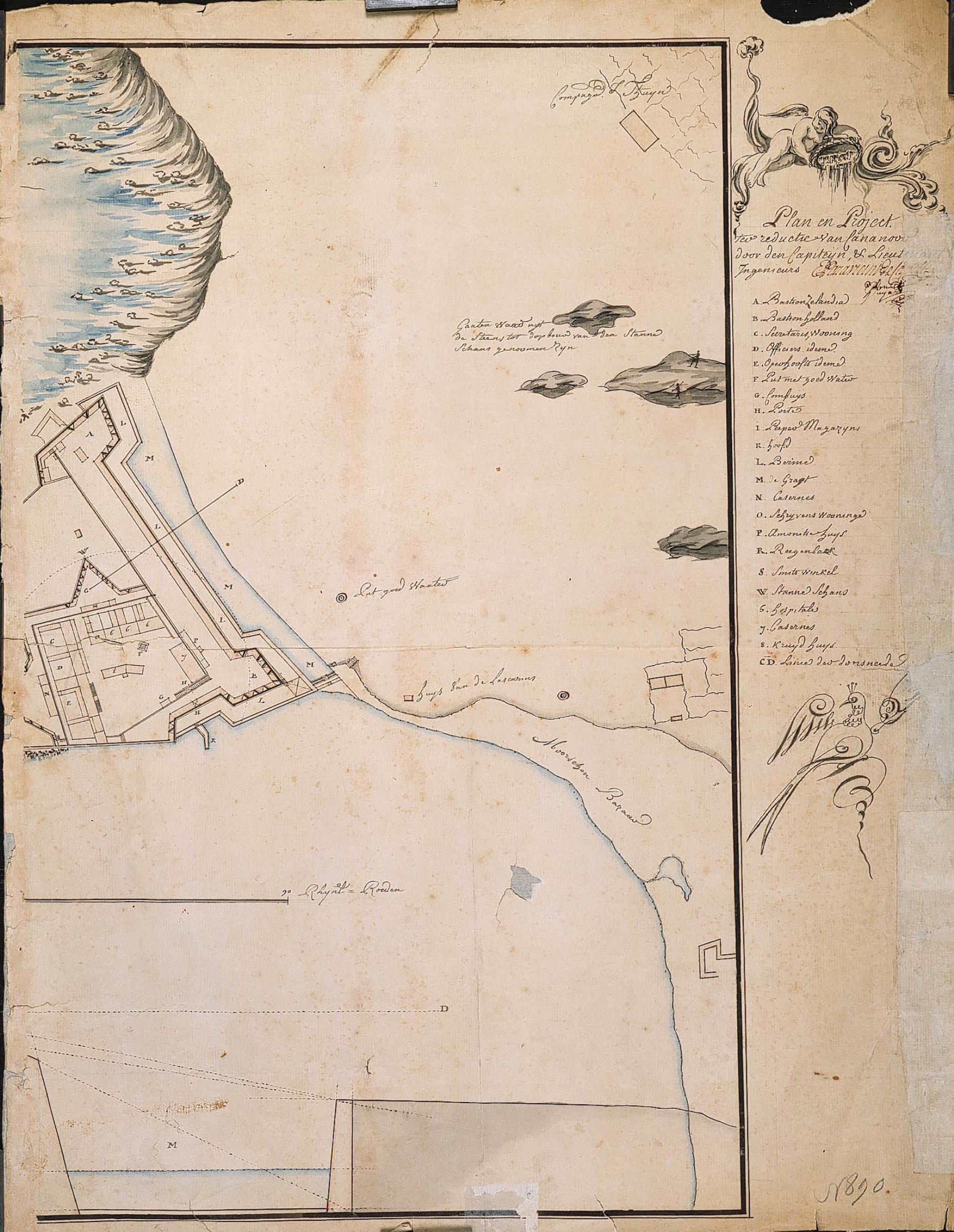
Nederlands: Titel catalogus Leupe (NA): Plan en Project ter reductie van Cananoor.
Legenda: A-W; 6, 7, 8, CD Topografische namen vermeld op deze kaart: Cananoor, Bastion Zeelandia, Bastion Holland. Deze kaart wordt door Leupe gedateerd op 1767.English: According to catalogue Leupe (NA), the original title reads: Plan en Project ter reductie van Cananoor.
Key: A-W; 6, 7, 8, CD Topographical names mentioned on this map: Cananoor, Bastion Zeelandia, Bastion Holland. This map is dated by Leupe at 1767.Bahasa Indonesia: Menurut katalog Leupe (AN), judul yang asli yaitu: Plan en Project ter reductie van Cananoor.
Legenda: A-W; 6, 7, 8, CD Nama topografi yang disebutkan dalam peta ini: Cananoor, Bastion Zeelandia, Bastion Holland. Peta ini diberikan tanggal oleh Leupe pada 1767. |
|||||||||||||||||||||||
| Date | circa 1767 | |||||||||||||||||||||||
| Medium |
Nederlands: ingekleurde tekening op papier
English: coloured drawing on paper
Bahasa Indonesia: gambar berwarna di atas kertas |
|||||||||||||||||||||||
| Dimensions | height: 44 cm (17.3 in); width: 57 cm (22.4 in) | |||||||||||||||||||||||
| Collection |
|
|||||||||||||||||||||||
| Accession number |
NL-HaNA_4.VEL_890B (old number: VEL0890B) |
|||||||||||||||||||||||
| Inscriptions |
Plan en Project ter reductie van Cananoor
author: E. Paravicini / N. Guyard |
|||||||||||||||||||||||
| Notes |
English: Subjects: bird's-eye view / elevation, elevation / bird's-eye view, fortification, hospital / lazaret, garden / ornamental garden, warehouse, anchorage / pier / harbour, bazaar / market, key, encampment / military base, banderole / cartouche / ornamentation
Nederlands: Onderwerpen: vogelvlucht / opstand, opstand / vogelvlucht, vesting, ziekenhuis / lazaret, tuin / siertuin, pakhuis, rede / haven / pier, bazaar / markt, legenda, kampement / legerplaats, banderol / cartouche / versiering
English: Post: this image is related to a VOC trading post called Cannanore |
|||||||||||||||||||||||
| Source/Photographer |
|
|||||||||||||||||||||||
| Permission (Reusing this file) |
|
|||||||||||||||||||||||

| Object location | | View this and other nearby images on: OpenStreetMap |
|---|
File history
Click on a date/time to view the file as it appeared at that time.
| Date/Time | Thumbnail | Dimensions | User | Comment | |
|---|---|---|---|---|---|
| current | 16:01, 10 June 2014 | | 1,859 × 2,400 (670 KB) | HuskyBot (talk | contribs) | == {{int:filedesc}} == {{Artwork |title = {{nl|1=Plan ter verkleining van het fort van Cananoor}} {{en|1=Plan to reduce the fort at Cananoor}} |description = {{nl|1=Titel catalogus Leupe (NA): ''Plan en Project... |
You cannot overwrite this file.
File usage on Commons
The following page uses this file: