File:AMH-2543-NA Map of the Fort of Good Hope.jpg

Original file (2,400 × 1,850 pixels, file size: 659 KB, MIME type: image/jpeg)
Captions
Captions
Summary[edit]
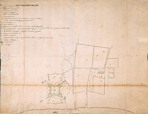
Nederlands: Plattegrond van fort de Goede Hoop
English: Map of the Fort of Good Hope( |
||||||||||||||||||||||||
|---|---|---|---|---|---|---|---|---|---|---|---|---|---|---|---|---|---|---|---|---|---|---|---|---|
| Author |
Nederlands: Anoniem / Anonymous
English: Anoniem / Anonymous |
|||||||||||||||||||||||
| Title |
Nederlands: Plattegrond van fort de Goede Hoop
English: Map of the Fort of Good Hope |
|||||||||||||||||||||||
| Description |
Nederlands: Titel catalogus Leupe (NA): Plan van fort de Goede Hoop, met het daarvoor gelegen Hoornwerk en bygelegen gebouwen, tuinen enz..
Kaart van het fort, de landerijen en gebouwen in omgeving van Kaap de Goede Hoop. Notities verso: 1654 van de Kaap II deel, nrs. 203; 498 d. Potlood Gedrukt Catal. Leupe 816. Legenda: a-rEnglish: According to the Leupe catalogue (NA), the original title reads: Plan van fort de Goede Hoop, met het daarvoor gelegen Hoornwerk en bygelegen gebouwen, tuinen enz..
Map of the fort, the surrounding estates and buildings of the Cape of Good Hope. Notes on reverse: 1654 van de Kaap II deel, nrs. 203; 498 d. Potlood Gedrukt Catal. Leupe 816. Key: a-r |
|||||||||||||||||||||||
| Date | circa 1654 | |||||||||||||||||||||||
| Medium |
Nederlands: pen op papier
English: pen on paper |
|||||||||||||||||||||||
| Dimensions | height: 530 mm (20.86 in); width: 420 mm (16.53 in) | |||||||||||||||||||||||
| Collection |
|
|||||||||||||||||||||||
| Accession number |
NL-HaNA_4.VEL_816 (old number: VEL0816) |
|||||||||||||||||||||||
| Inscriptions |
't binnen pleijn vant Fort de Goede Hoope
|
|||||||||||||||||||||||
| Notes |
English: Subjects: chart / map / plan, fortification, building, estate / plantation, garden / ornamental garden, key
Nederlands: Onderwerpen: plattegrond / kaart, vesting, gebouw, landerij / plantage, tuin / siertuin, legenda
English: Fort: this image is related to a VOC fort called kasteel de Goede Hoop |
|||||||||||||||||||||||
| Source/Photographer |
|
|||||||||||||||||||||||
| Permission (Reusing this file) |
|
|||||||||||||||||||||||

| Object location | | View this and other nearby images on: OpenStreetMap |
|---|
File history
Click on a date/time to view the file as it appeared at that time.
| Date/Time | Thumbnail | Dimensions | User | Comment | |
|---|---|---|---|---|---|
| current | 15:55, 10 June 2014 | | 2,400 × 1,850 (659 KB) | HuskyBot (talk | contribs) | == {{int:filedesc}} == {{Artwork |title = {{nl|1=Plattegrond van fort de Goede Hoop}} {{en|1=Map of the Fort of Good Hope}} |description = {{nl|1=Titel catalogus Leupe (NA): ''Plan van fort de Goede Hoop, met h... |
You cannot overwrite this file.
File usage on Commons
The following page uses this file: