File:AMH-2542-NA Ground plan and elevation of the Fort of Good Hope.jpg
Jump to navigation
Jump to search
Size of this preview: 778 × 600 pixels. Other resolutions: 311 × 240 pixels | 623 × 480 pixels | 996 × 768 pixels | 1,280 × 987 pixels | 2,400 × 1,850 pixels.
Original file (2,400 × 1,850 pixels, file size: 606 KB, MIME type: image/jpeg)
Captions
Captions
Add a one-line explanation of what this file represents
Summary[edit]
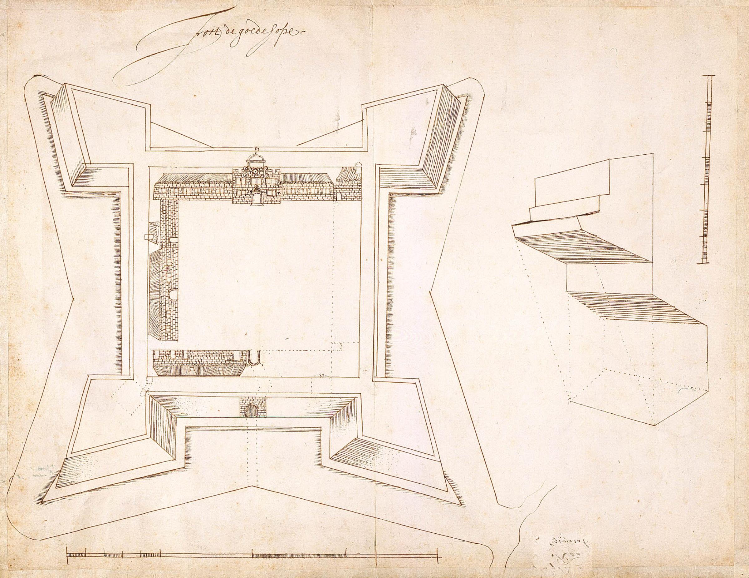
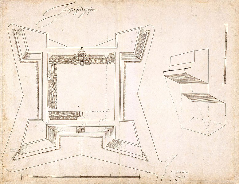
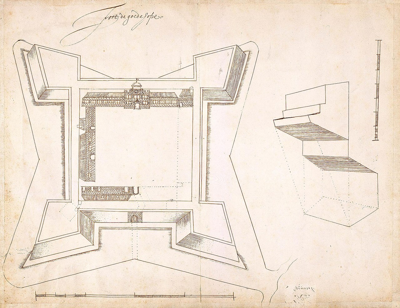
Nederlands: Plattegrond en opstand van fort de Goede Hoop
English: Ground plan and elevation of the Fort of Good Hope( |
||||||||||||||||||||||||
|---|---|---|---|---|---|---|---|---|---|---|---|---|---|---|---|---|---|---|---|---|---|---|---|---|
| Author |
Nederlands: Anoniem / Anonymous
English: Anoniem / Anonymous |
|||||||||||||||||||||||
| Title |
Nederlands: Plattegrond en opstand van fort de Goede Hoop
English: Ground plan and elevation of the Fort of Good Hope |
|||||||||||||||||||||||
| Description |
Nederlands: Titel catalogus Leupe (NA): Plan als voren, en opstand, hier wordt bedoeld de titel van VEL0814: Plan van fort de Goede Hoop.
Notities verso: 't fort de goede hope'nr. 11; 498c en nr. 245 doorgehaald.
English: According to the Leupe catalogue (NA), the original title reads: Plan als voren, en opstand, referring to the title of VEL0814: Plan van fort de Goede Hoop.
Notes on reverse: 't fort de goede hope nr. 11; 498c en nr. 245 doorgehaald. |
|||||||||||||||||||||||
| Date | circa 1653 | |||||||||||||||||||||||
| Medium |
Nederlands: pen op papier
English: pen on paper |
|||||||||||||||||||||||
| Dimensions | height: 410 mm (16.14 in); width: 320 mm (12.59 in) | |||||||||||||||||||||||
| Collection |
|
|||||||||||||||||||||||
| Accession number |
NL-HaNA_4.VEL_815 (old number: VEL0815) |
|||||||||||||||||||||||
| Inscriptions |
Fort de goede hope
|
|||||||||||||||||||||||
| Notes |
English: Subjects: chart / map / plan, fortification, cross-section / profile
Nederlands: Onderwerpen: plattegrond / kaart, vesting, doorsnede / profiel
English: Fort: this image is related to a VOC fort called kasteel de Goede Hoop |
|||||||||||||||||||||||
| Source/Photographer |
|
|||||||||||||||||||||||
| Permission (Reusing this file) |
|
|||||||||||||||||||||||

| Object location | | View this and other nearby images on: OpenStreetMap |
|---|
File history
Click on a date/time to view the file as it appeared at that time.
| Date/Time | Thumbnail | Dimensions | User | Comment | |
|---|---|---|---|---|---|
| current | 15:54, 10 June 2014 | | 2,400 × 1,850 (606 KB) | HuskyBot (talk | contribs) | == {{int:filedesc}} == {{Artwork |title = {{nl|1=Plattegrond en opstand van fort de Goede Hoop}} {{en|1=Ground plan and elevation of the Fort of Good Hope}} |description = {{nl|1=Titel catalogus Leupe (NA): ''P... |
You cannot overwrite this file.
File usage on Commons
The following page uses this file: