File:AMH-2535-NA Plan of the Fort of Good Hope.jpg

Original file (2,400 × 1,729 pixels, file size: 627 KB, MIME type: image/jpeg)
Captions
Captions
Summary[edit]
Nederlands: Kaart van het fort de Goede Hoop
English: Plan of the Fort of Good Hope( |
||||||||||||||||||||||||
|---|---|---|---|---|---|---|---|---|---|---|---|---|---|---|---|---|---|---|---|---|---|---|---|---|
| Author |
Nederlands: Anoniem / Anonymous
English: Anoniem / Anonymous |
|||||||||||||||||||||||
| Title |
Nederlands: Kaart van het fort de Goede Hoop
English: Plan of the Fort of Good Hope |
|||||||||||||||||||||||
| Description |
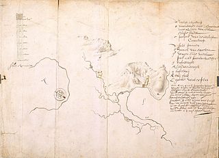
Nederlands: Titel catalogus Leupe (NA): Als voren, hier wordt de titel bedoeld van VEL0803 Kaart van het Fort de Goede Hoop en de daaromheen gelegen landen, tusschen de Tafelbaai en Baai Fals.
Kaart van de aanleg van drie wachthuizen tussen de redouten Duin en Coorenhoop voor de defensie van de korenvelden en het wagenpad van de Tafelbaai landinwaarts. Notities verso: Voor Amsterdam, Kaap 1656/57 no 5; 488 a; 527 of 327. Bij de schaalaanduiding staat tevens vermeld: Scale de Roemaat. Legenda: a-l Topografische namen aangeduid op deze kaart: tafelbaij, Leeuwenbergh, tafelbergh, zoutpan.English: According to the Leupe catalogue (NA), the original title reads:Als voren, referring to the title of VEL0803 Kaart van het Fort de Goede Hoop en de daaromheen gelegen landen, tusschen de Tafelbaai en Baai Fals.
Map of the construction of three guard posts between the redoubt Duin and Coorenhoop for the protection of cornfields and the wagon trail leading from Table Bay into the interior. Notes on the reverse: Voor Amsterdam, Kaap 1656/57 no 5; 488 a; 527 of 327. Alongside the indication of scale the following: Scale de Roemaat. Key: a-l The topographical names mentioned on this map are: tafelbaij, Leeuwenbergh, tafelbergh, zoutpan. |
|||||||||||||||||||||||
| Date | between 1656 and 1657 | |||||||||||||||||||||||
| Medium |
Nederlands: ingekleurde tekening op papier
English: coloured drawing on paper |
|||||||||||||||||||||||
| Dimensions | height: 530 mm (20.86 in); width: 390 mm (15.35 in) | |||||||||||||||||||||||
| Collection |
|
|||||||||||||||||||||||
| Accession number |
NL-HaNA_4.VEL_804 (old number: VEL0804) |
|||||||||||||||||||||||
| Inscriptions |
-
|
|||||||||||||||||||||||
| Notes |
English: Subjects: chart / map / plan, survey / view, fortification, guard house / tollbooth, compass / dial, key
Nederlands: Onderwerpen: plattegrond / kaart, overzicht / aanzicht, vesting, tolhuis / wachthuis, kompas / windroos, legenda |
|||||||||||||||||||||||
| Source/Photographer |
|
|||||||||||||||||||||||
| Permission (Reusing this file) |
|
|||||||||||||||||||||||

File history
Click on a date/time to view the file as it appeared at that time.
| Date/Time | Thumbnail | Dimensions | User | Comment | |
|---|---|---|---|---|---|
| current | 15:53, 10 June 2014 | | 2,400 × 1,729 (627 KB) | HuskyBot (talk | contribs) | == {{int:filedesc}} == {{Artwork |title = {{nl|1=Kaart van het fort de Goede Hoop}} {{en|1=Plan of the Fort of Good Hope}} |description = {{nl|1=Titel catalogus Leupe (NA): ''Als voren'', hier wordt de titel be... |
You cannot overwrite this file.
File usage on Commons
The following page uses this file: