File:AMH-2514-NA Harbour or bay of Gale.jpg
Jump to navigation
Jump to search
Size of this preview: 420 × 600 pixels. Other resolutions: 168 × 240 pixels | 336 × 480 pixels | 538 × 768 pixels | 717 × 1,024 pixels | 1,681 × 2,400 pixels.
Original file (1,681 × 2,400 pixels, file size: 396 KB, MIME type: image/jpeg)
Captions
Captions
Add a one-line explanation of what this file represents
Summary[edit]
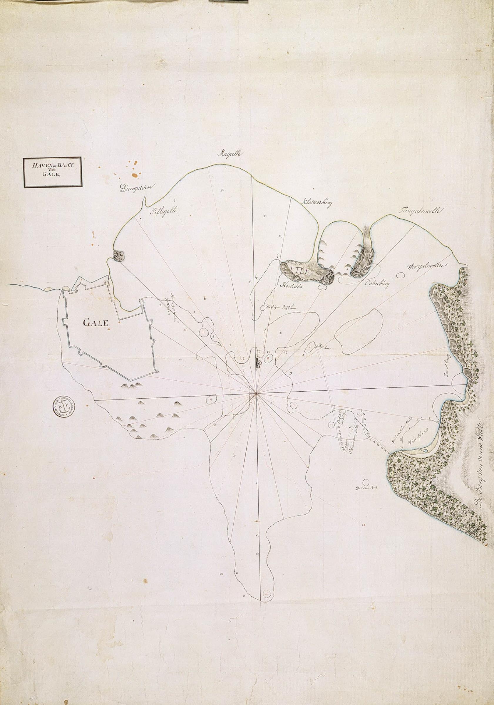
Nederlands: Haven of baai van Gale
English: Harbour or bay of Gale( |
||||||||||||||||||||||||
|---|---|---|---|---|---|---|---|---|---|---|---|---|---|---|---|---|---|---|---|---|---|---|---|---|
| Author |
Nederlands: Anoniem / Anonymous
English: Anoniem / Anonymous |
|||||||||||||||||||||||
| Title |
Nederlands: Haven of baai van Gale
English: Harbour or bay of Gale |
|||||||||||||||||||||||
| Description |
Nederlands: Titel catalogus Leupe (NA): Haven of Baai van Gale.
Topografische namen vermeld op deze kaart: Magalle, Tangalmoelle, Wacgalmodere, Calenburg, Herkules, Klossenburg, Dangiddere, den Berg van Oenewatte.
English: According to the Leupe catalogue (NA), the original title reads: Haven of Baai van Gale.
Topographical names mentioned on this chart: Magalle, Tangalmoelle, Wacgalmodere, Calenburg, Herkules, Klossenburg, Dangiddere, den Berg van Oenewatte. |
|||||||||||||||||||||||
| Date | between 1700 and 1800 | |||||||||||||||||||||||
| Medium |
Nederlands: ingekleurde tekening op papier
English: coloured drawing on paper |
|||||||||||||||||||||||
| Dimensions | height: 535 mm (21.06 in); width: 750 mm (29.52 in) | |||||||||||||||||||||||
| Collection |
|
|||||||||||||||||||||||
| Accession number |
NL-HaNA_4.VEL_247 (old number: VEL0247) |
|||||||||||||||||||||||
| Inscriptions |
Haven of Baay van Gale,
|
|||||||||||||||||||||||
| Notes |
English: Subjects: chart / map / plan, anchorage / pier / harbour, banderole / cartouche / ornamentation
Nederlands: Onderwerpen: plattegrond / kaart, rede / haven / pier, banderol / cartouche / versiering
English: Post: this image is related to a VOC trading post called Galle |
|||||||||||||||||||||||
| Source/Photographer |
|
|||||||||||||||||||||||
| Permission (Reusing this file) |
|
|||||||||||||||||||||||

| Object location | | View this and other nearby images on: OpenStreetMap |
|---|
File history
Click on a date/time to view the file as it appeared at that time.
| Date/Time | Thumbnail | Dimensions | User | Comment | |
|---|---|---|---|---|---|
| current | 15:49, 10 June 2014 | | 1,681 × 2,400 (396 KB) | HuskyBot (talk | contribs) | == {{int:filedesc}} == {{Artwork |title = {{nl|1=Haven of baai van Gale}} {{en|1=Harbour or bay of Gale}} |description = {{nl|1=Titel catalogus Leupe (NA): ''Haven of Baai van Gale''. Topografische namen verme... |
You cannot overwrite this file.
File usage on Commons
The following page uses this file: