File:AMH-2487-NA Ground plan of the stables at Cape of Good Hope.jpg

Original file (2,400 × 1,445 pixels, file size: 331 KB, MIME type: image/jpeg)
Captions
Captions
Summary[edit]
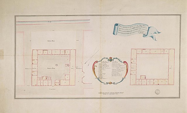
Nederlands: Plattegrond van de stallen in Kaap de Goede Hoop
English: Ground plan of the stables at Cape of Good Hope( |
||||||||||||||||||||||||
|---|---|---|---|---|---|---|---|---|---|---|---|---|---|---|---|---|---|---|---|---|---|---|---|---|
| Author |
Creator:Joh. Wilh. Wernich Creator:I. Rhenius Creator:O.G. de Wet Nederlands: Joh. Wilh. Wernich (landmeter / kaartenmaker), I. Rhenius (opdrachtgever), O.G. de Wet (opdrachtgever)
English: Joh. Wilh. Wernich (land surveyor / mapmaker), I. Rhenius (patron), O.G. de Wet (patron) |
|||||||||||||||||||||||
| Title |
Nederlands: Plattegrond van de stallen in Kaap de Goede Hoop
English: Ground plan of the stables at Cape of Good Hope |
|||||||||||||||||||||||
| Description |
Nederlands: Titel catalogus Leupe (NA): Plan van S. Ed. Comps. stal met het daaragter liggend plein.
Notities verso: Blauw etiket 'Nr. 1 Plan van de compagnies stal aan Kaap de Goede Hoop' register 11, deel 1, folio 42. Gehoord tot de bijlage nr. 30 La. C. Nr. 53. Legenda: 1-14 Afmetingen totaal: H 666 x B 1025 mmEnglish: The original title according to the catalogue Leupe (NA) reads: Plan van S. Ed. Comps. stal met het daaragter liggend plein.
Notes on reverse: Blauw etiket 'Nr. 1 Plan van de compagnies stal aan Kaap de Goede Hoop', register 11, deel 1, folio 42. Gehoord tot de bijlage nr. 30 La. C. Nr. 53. Key: 1-14 Measurements of the whole: 666 (height) x 1025 mm (width). |
|||||||||||||||||||||||
| Date | 1791 | |||||||||||||||||||||||
| Medium |
Nederlands: ingekleurde tekening op papier
English: coloured drawing on paper |
|||||||||||||||||||||||
| Collection |
|
|||||||||||||||||||||||
| Accession number |
NL-HaNA_4.VEL_842 (old number: VEL0842) |
|||||||||||||||||||||||
| Inscriptions |
Plan van S. E. Compagnies Stal met 't daar agter liggend Plein
author: Joh:s Wilh:m Wernich |
|||||||||||||||||||||||
| Notes |
English: Subjects: chart / map / plan, building, menagerie / stable, banderole / cartouche / ornamentation, key
Nederlands: Onderwerpen: plattegrond / kaart, gebouw, menagerie / stal, banderol / cartouche / versiering, legenda
English: Post: this image is related to a VOC trading post called Cape Town |
|||||||||||||||||||||||
| Source/Photographer |
|
|||||||||||||||||||||||
| Permission (Reusing this file) |
|
|||||||||||||||||||||||

| Object location | | View this and other nearby images on: OpenStreetMap |
|---|
File history
Click on a date/time to view the file as it appeared at that time.
| Date/Time | Thumbnail | Dimensions | User | Comment | |
|---|---|---|---|---|---|
| current | 15:44, 10 June 2014 | | 2,400 × 1,445 (331 KB) | HuskyBot (talk | contribs) | == {{int:filedesc}} == {{Artwork |title = {{nl|1=Plattegrond van de stallen in Kaap de Goede Hoop}} {{en|1=Ground plan of the stables at Cape of Good Hope}} |description = {{nl|1=Titel catalogus Leupe (NA): ''P... |
You cannot overwrite this file.
File usage on Commons
The following page uses this file: