File:AMH-2486-NA Ground plan of the hospital at Cape of Good Hope.jpg
Jump to navigation
Jump to search

Size of this preview: 389 × 599 pixels. Other resolutions: 156 × 240 pixels | 311 × 480 pixels | 498 × 768 pixels | 665 × 1,024 pixels | 1,558 × 2,400 pixels.
Original file (1,558 × 2,400 pixels, file size: 499 KB, MIME type: image/jpeg)
Captions
Captions
Add a one-line explanation of what this file represents
Summary[edit]
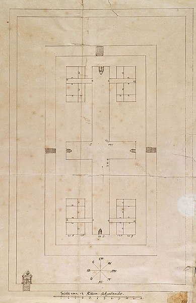
Nederlands: Plattegrond van het ziekenhuis van Kaap de Goede Hoop
English: Ground plan of the hospital at Cape of Good Hope( |
||||||||||||||||||||||||
|---|---|---|---|---|---|---|---|---|---|---|---|---|---|---|---|---|---|---|---|---|---|---|---|---|
| Author |
Nederlands: Anoniem / Anonymous
English: Anoniem / Anonymous |
|||||||||||||||||||||||
| Title |
Nederlands: Plattegrond van het ziekenhuis van Kaap de Goede Hoop
English: Ground plan of the hospital at Cape of Good Hope |
|||||||||||||||||||||||
| Description |
Nederlands: Titel catalogus Leupe (NA): Platte grond van het Ziekenhuis of hospitaal aan de Kaap de Goede Hoop.
Notities verso: Model van het ziekenhuis aan de Kaap uit brieven en papieren Kaap overgek. 1697, nr. 57; Andere nrs. 1166; 498aa; 47.
English: The original title according to the Leupe (NA) catalogue reads: Platte grond van het Ziekenhuis of hospitaal aan de Kaap de Goede Hoop.
Notes on reverse: Model van het ziekenhuis aan de Kaap uit brieven en papieren Kaap overgek. 1697, nr. 57; Andere nrs. 1166; 498aa; 47. |
|||||||||||||||||||||||
| Date | circa 1697 | |||||||||||||||||||||||
| Medium |
Nederlands: pen op papier
English: pen on paper |
|||||||||||||||||||||||
| Dimensions | height: 30.5 cm (12 in); width: 49 cm (19.2 in) | |||||||||||||||||||||||
| Collection |
|
|||||||||||||||||||||||
| Accession number |
NL-HaNA_4.VEL_841 (old number: VEL0841) |
|||||||||||||||||||||||
| Inscriptions |
-
|
|||||||||||||||||||||||
| Notes |
English: Subjects: chart / map / plan, building, hospital / lazaret, compass / dial
Nederlands: Onderwerpen: plattegrond / kaart, gebouw, ziekenhuis / lazaret, kompas / windroos
English: Post: this image is related to a VOC trading post called Cape Town |
|||||||||||||||||||||||
| Source/Photographer |
|
|||||||||||||||||||||||
| Permission (Reusing this file) |
|
|||||||||||||||||||||||

| Object location | | View this and other nearby images on: OpenStreetMap |
|---|
File history
Click on a date/time to view the file as it appeared at that time.
| Date/Time | Thumbnail | Dimensions | User | Comment | |
|---|---|---|---|---|---|
| current | 15:44, 10 June 2014 | | 1,558 × 2,400 (499 KB) | HuskyBot (talk | contribs) | == {{int:filedesc}} == {{Artwork |title = {{nl|1=Plattegrond van het ziekenhuis van Kaap de Goede Hoop}} {{en|1=Ground plan of the hospital at Cape of Good Hope}} |description = {{nl|1=Titel catalogus Leupe (NA... |
You cannot overwrite this file.
File usage on Commons
The following page uses this file: