File:61 RRs in US 1840.png
Jump to navigation
Jump to search
Size of this preview: 589 × 599 pixels. Other resolutions: 236 × 240 pixels | 472 × 480 pixels | 746 × 759 pixels.
Original file (746 × 759 pixels, file size: 1.15 MB, MIME type: image/png)
Captions
Captions
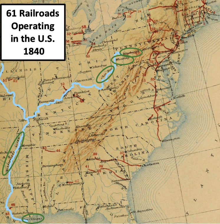
Although the Ohio and Mississippi Rivers continued to be important means for transportation, 61 railroads were operating in the United States by 1840
Summary
[edit]
| Description |
English: This is a map that shows the location of railroad line (in red) in the United States in 1840. The first commercial railroad in the country began construction in 1828 in Baltimore. By 1840, 61 railroads were operating in the United States. Glassmakers in Pittsburgh and Wheeling used the Ohio River as a major means of transportation, and soon would have additional resources from railroad lines. The Ohio and Mississippi rivers are highlighted in sky-blue |
| Date | |
| Source | This map is from the book "History of Transportation in the United States before 1860", published in 1917. It has been modified by TwoScarsUp as a crop of the page with a label, highlighting two rivers, and circling four labels. |
| Author | Prepared under the direction of Balthasar Henry Meyer by Caroline E. MacGill and a staff of collaborators |
Licensing
[edit]
This work is in the public domain in the United States because it was published (or registered with the U.S. Copyright Office) before January 1, 1929.
Public domain works must be out of copyright in both the United States and in the source country of the work in order to be hosted on the Commons. If the work is not a U.S. work, the file must have an additional copyright tag indicating the copyright status in the source country.
Note: This tag should not be used for sound recordings. |
File history
Click on a date/time to view the file as it appeared at that time.
| Date/Time | Thumbnail | Dimensions | User | Comment | |
|---|---|---|---|---|---|
| current | 21:39, 29 February 2024 | | 746 × 759 (1.15 MB) | TwoScarsUp (talk | contribs) | Uploaded a work by Prepared under the direction of Balthasar Henry Meyer by Caroline E. MacGill and a staff of collaborators from This map is from the book "History of Transportation in the United States before 1860", published in 1917. It has been modified by TwoScarsUp as a crop of the page with a label, highlighting two rivers, and circling four labels. with UploadWizard |
You cannot overwrite this file.
File usage on Commons
There are no pages that use this file.
File usage on other wikis
The following other wikis use this file:
- Usage on en.wikipedia.org