File:42 Apollo in bosquet Fächer, gardens of Schönbrunn 02.jpg
Jump to navigation
Jump to search

Size of this preview: 800 × 538 pixels. Other resolutions: 320 × 215 pixels | 640 × 430 pixels | 1,024 × 688 pixels | 1,280 × 860 pixels | 2,560 × 1,720 pixels | 4,798 × 3,224 pixels.
Original file (4,798 × 3,224 pixels, file size: 7.66 MB, MIME type: image/jpeg)
Captions
Captions
Add a one-line explanation of what this file represents
Summary[edit]
| Description |
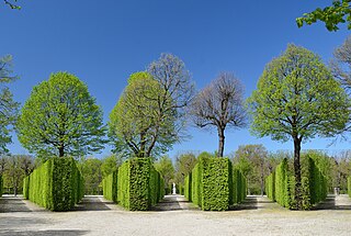
Deutsch: Ein Boskett („Wäldchen“ oder „Gebüsch“) in den Gärten von Schloss Schönbrunn in Wien, bestehend aus beschnittenen Hecken und Bäumen auf einem fächerförmigen Grundriss, genannt „der Fächer“. Die Gartenarchitektur des Schlosses wurde hauptsächlich in der Regierungszeit Maria Theresias (1740 - 1780) geplant und errichtet und bildet seither zusammen mit den Gebäuden ein barockes Ensemble, das 1996 in seiner Gesamtheit in die Liste des Weltkulturerbes der UNESCO aufgenommen wurde. Charakteristisch für die Gärten sind zahlreiche Skulpturen, von denen die Statue Apollos von Johann Baptist Hagenauer hier den Mittelpunkt der zentralen Allee bildet. Die Statue trägt die Nr. 42 auf der Karte des Schlossparks: [1]
English: A Bosquet ("copse") in the gardens of Schönbrunn Palace in Vienna, consisting of hedges and trees. It is shaped like a fan and therefore it is called "der Fächer" in German language. The gardens have been designed mainly during the reign of Maria Theresia (1740 - 1780) and have been preserved together with the buildings as a remarkable Baroque ensemble, which was catalogued on the World Heritage List of the UNESCO in 1996. A characteristical feature of the gardens are numerous sculptures. The statue of Apollo by Johann Baptist Hagenauer can be seen in the background of the central alley. It is numbered as no. 42 in the map of Schönbrunn: [2]
Русский: Боскет «Веер» (Der Fächer) в садах дворца Шенбрунн, на заднем плане статуя №42 «Апполон», работы Йозефа Баптиста Агенауэра. Вена, Австрия
|
|||
| Date | ||||
| Source | Own work | |||
| Author | Herzi Pinki |

| Camera location | | View this and other nearby images on: OpenStreetMap |
|---|
Licensing[edit]
I, the copyright holder of this work, hereby publish it under the following license:
This file is licensed under the Creative Commons Attribution-Share Alike 4.0 International license.
- You are free:
- to share – to copy, distribute and transmit the work
- to remix – to adapt the work
- Under the following conditions:
- attribution – You must give appropriate credit, provide a link to the license, and indicate if changes were made. You may do so in any reasonable manner, but not in any way that suggests the licensor endorses you or your use.
- share alike – If you remix, transform, or build upon the material, you must distribute your contributions under the same or compatible license as the original.

|
This image was uploaded as part of Wiki Loves Monuments 2015.
|
File history
Click on a date/time to view the file as it appeared at that time.
| Date/Time | Thumbnail | Dimensions | User | Comment | |
|---|---|---|---|---|---|
| current | 11:05, 6 September 2015 | | 4,798 × 3,224 (7.66 MB) | Herzi Pinki (talk | contribs) | User created page with UploadWizard |
You cannot overwrite this file.
File usage on Commons
The following page uses this file:
- File:44 Apollo in bosquet Fächer, gardens of Schönbrunn 02.jpg (file redirect)
File usage on other wikis
The following other wikis use this file:
- Usage on ja.wikipedia.org