File:2020 Luftblid Kalthausen.png
Jump to navigation
Jump to search

Size of this preview: 800 × 466 pixels. Other resolutions: 320 × 186 pixels | 640 × 373 pixels | 1,024 × 596 pixels | 1,472 × 857 pixels.
Original file (1,472 × 857 pixels, file size: 2.32 MB, MIME type: image/png)
Captions
Captions
Add a one-line explanation of what this file represents
Summary
[edit]
| Description |
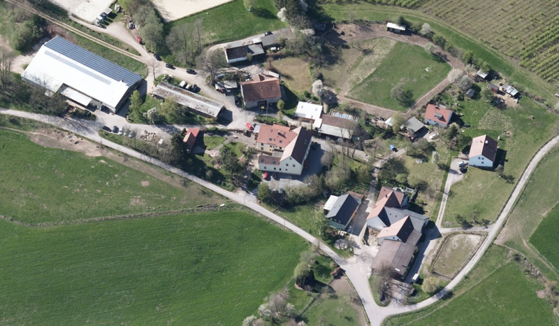
Deutsch: Schrägluftbild von Norden auf den Wohnplatz Kalthausen im Hagener Stadtteil Dahl. Erstmals urkundlich 1315 als Kalthůsen in parrochia Dale erwähnt. Später im Jahr 1486 auch als Kalthuser burschop (Bauerschaft). 1574 Mertin tho Kalthusen. 1588 Caspar to Kaldhusen. |
| Date | |
| Source | https://www.3d.ruhr/#/ |
| Author | © RVR, 2020, dl-de/by-2-0 |
Licensing
[edit]

|
This file is licensed under the terms of the Data licence Germany – attribution – version 2.0 |
|
You are free:
Under the following conditions:
|
File history
Click on a date/time to view the file as it appeared at that time.
| Date/Time | Thumbnail | Dimensions | User | Comment | |
|---|---|---|---|---|---|
| current | 16:30, 27 October 2020 | | 1,472 × 857 (2.32 MB) | Bärwinkel,Klaus (talk | contribs) | {{Information |Description={{de|1=Schrägluftbild von Norden auf den Wohnplatz Kalthausen im Hagener Stadtteil Dahl.}} |Source=Ruhr |Date=2020-10-27 |Author=Geonetzwerk.metropoleRuhr – Schrägluftbild-Viewer 3D.RUHR |Permission= |other_versions= }} Category:Aerial photographs of Hagen Category:Landschaftsschutzgebiet westlich Priorei |
You cannot overwrite this file.
File usage on Commons
There are no pages that use this file.