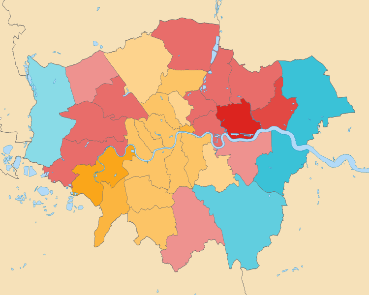
File:2019 European Parliament election in the United Kingdom area results (Greater London) with Gradation.svg

Original file (SVG file, nominally 1,425 × 1,140 pixels, file size: 725 KB)
Captions
Captions
Summary[edit]
| Description2019 European Parliament election in the United Kingdom area results (Greater London) with Gradation.svg |
English: This is a remake of 2019 European Parliament election in the United Kingdom area results (Greater London) with Gradation.png I created in 2019, now in svg. The map shows the single-most popular party in each borough for the 2019 European Parliament election in the Greater London at-large region. Gradation means the saturation of colour matches such popularity. Election data from the Lewisham Council Website
The colours are: Labour Party Liberal Democrats Brexit Party |
|||
| Date | ||||
| Source | Own work (Contains Ordnance Survey data © Crown copyright and database right) | |||
| Author | Twotwofourtysix | |||
| SVG development InfoField |
|
Licensing[edit]
- You are free:
- to share – to copy, distribute and transmit the work
- to remix – to adapt the work
- Under the following conditions:
- attribution – You must give appropriate credit, provide a link to the license, and indicate if changes were made. You may do so in any reasonable manner, but not in any way that suggests the licensor endorses you or your use.
- share alike – If you remix, transform, or build upon the material, you must distribute your contributions under the same or compatible license as the original.
File history
Click on a date/time to view the file as it appeared at that time.
| Date/Time | Thumbnail | Dimensions | User | Comment | |
|---|---|---|---|---|---|
| current | 08:44, 24 November 2021 |  | 1,425 × 1,140 (725 KB) | Twotwofourtysix (talk | contribs) | {{Information | description = {{en|1=This is a remake of File:2019 European Parliament election in the United Kingdom area results (Greater London) with Gradation.png I created in 2019, now in svg. The map shows the single-most popular party in each borough for the 2019 European Parliament election in the Greater London at-large region. Gradation means the saturation of colour matches such popularity. Election data from the [https://lewisham.gov.uk/mayorandcouncil/elections/results/elect... |
You cannot overwrite this file.
File usage on Commons
The following 3 pages use this file:
Metadata
This file contains additional information such as Exif metadata which may have been added by the digital camera, scanner, or software program used to create or digitize it. If the file has been modified from its original state, some details such as the timestamp may not fully reflect those of the original file. The timestamp is only as accurate as the clock in the camera, and it may be completely wrong.
| Width | 1425 |
|---|---|
| Height | 1140 |

