File:2015 Southern Syria offensive.svg
Jump to navigation
Jump to search

Size of this PNG preview of this SVG file: 370 × 600 pixels. Other resolutions: 148 × 240 pixels | 296 × 480 pixels | 473 × 768 pixels | 631 × 1,024 pixels | 1,263 × 2,048 pixels | 1,958 × 3,175 pixels.
Original file (SVG file, nominally 1,958 × 3,175 pixels, file size: 11.18 MB)
Captions
Captions
Add a one-line explanation of what this file represents
Summary[edit]
| Description |
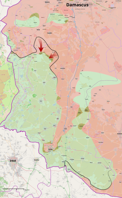
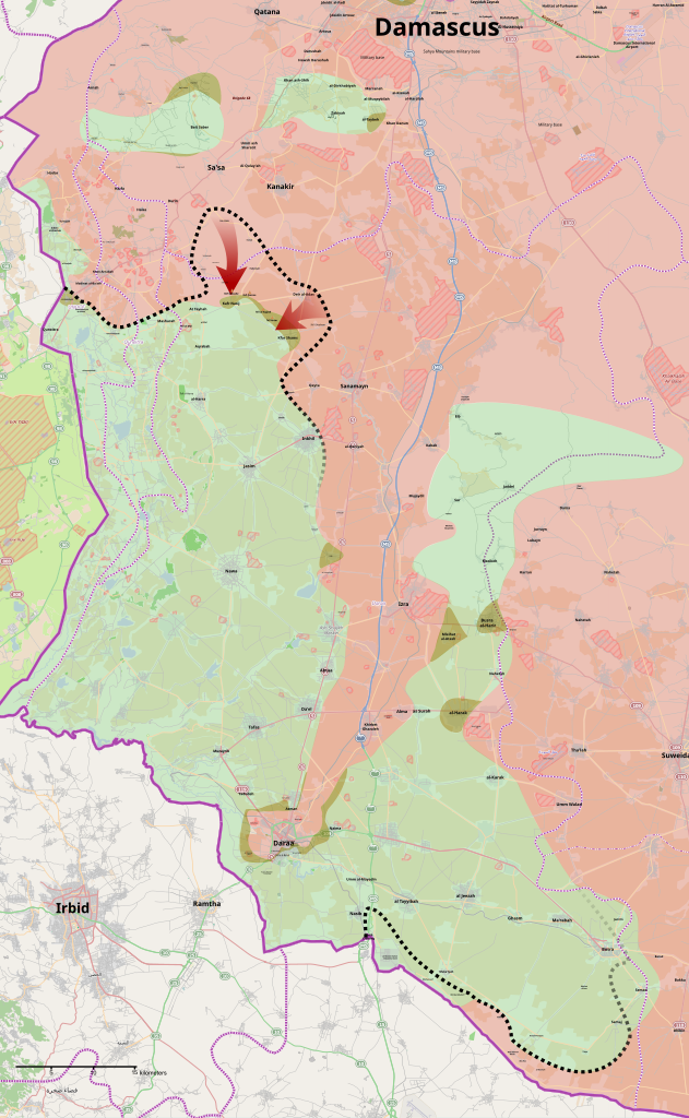
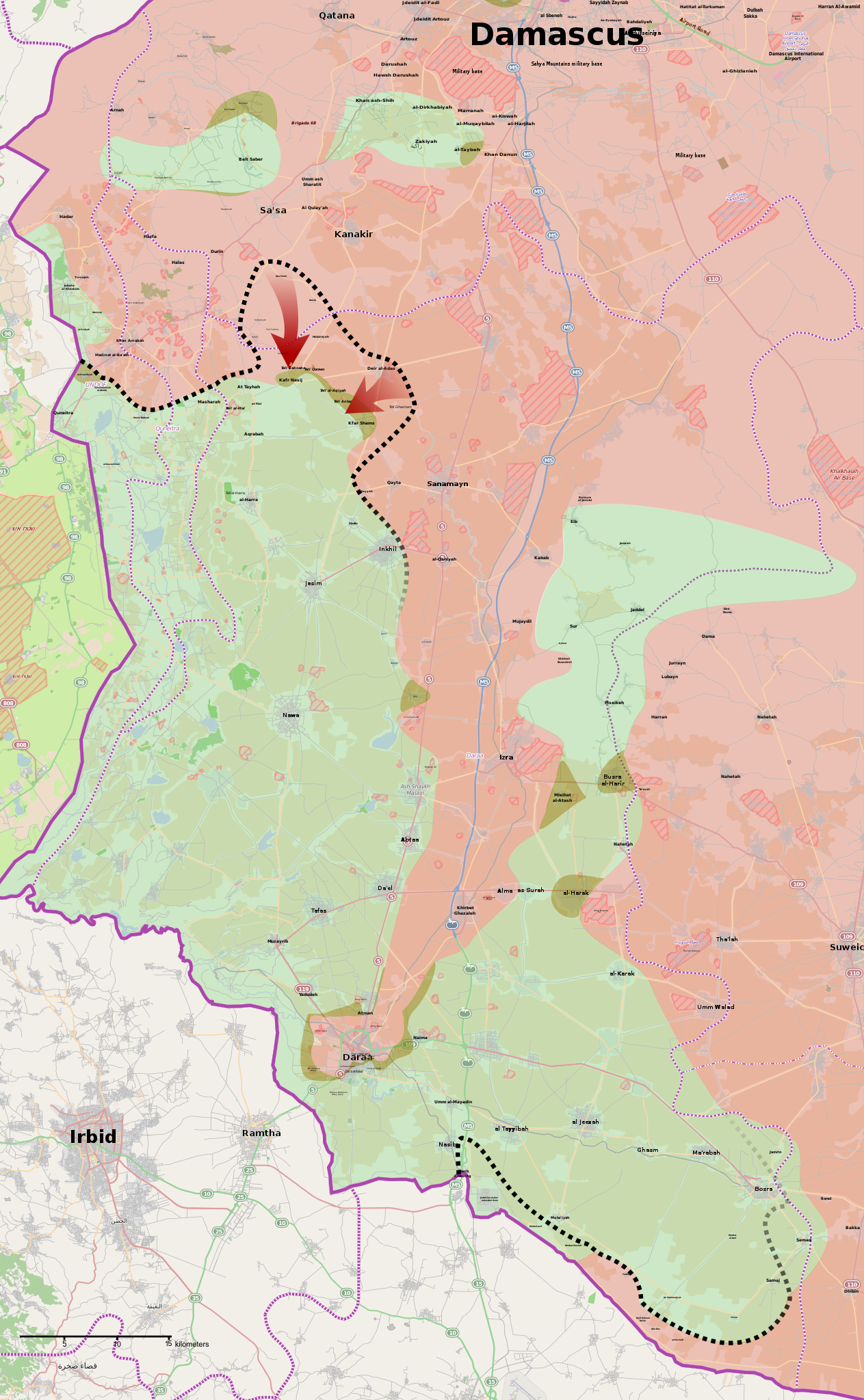
English: Map of the 2015 Southern Syria offensive. Black dotted line shows the frontline prior to the offensive. Map covers Syria's Quneitra and Daraa Governorates, as well as parts of the Rif Dimashq Governorate.
Syrian Government control
Opposition control
Contested |
| Date | |
| Source | Own work |
| Author | MrPenguin20 |
Licensing[edit]
| This work contains information from OpenStreetMap, which is made available under the Open Database License (ODbL).
The ODbL does not require any particular license for maps produced from ODbL data. Prior to 1 August 2020, map tiles produced by the OpenStreetMap Foundation were licensed under the CC-BY-SA-2.0 license. Maps produced by other people may be subject to other licences. |
I, the copyright holder of this work, hereby publish it under the following license:
This file is licensed under the Creative Commons Attribution-Share Alike 4.0 International license.
- You are free:
- to share – to copy, distribute and transmit the work
- to remix – to adapt the work
- Under the following conditions:
- attribution – You must give appropriate credit, provide a link to the license, and indicate if changes were made. You may do so in any reasonable manner, but not in any way that suggests the licensor endorses you or your use.
- share alike – If you remix, transform, or build upon the material, you must distribute your contributions under the same or compatible license as the original.
File history
Click on a date/time to view the file as it appeared at that time.
| Date/Time | Thumbnail | Dimensions | User | Comment | |
|---|---|---|---|---|---|
| current | 00:43, 4 April 2015 | | 1,958 × 3,175 (11.18 MB) | MrPenguin20 (talk | contribs) | Updates around Jordan border & Bosra. |
| 17:41, 10 March 2015 |  | 1,958 × 3,175 (11.17 MB) | MrPenguin20 (talk | contribs) | Increased text for hills. Marked hills better (with little hill icon) | |
| 18:40, 28 February 2015 |  | 1,958 × 3,175 (11.17 MB) | MrPenguin20 (talk | contribs) | Numerous updates post govt advance. | |
| 00:39, 20 February 2015 |  | 1,958 × 3,175 (11.18 MB) | MrPenguin20 (talk | contribs) | Fixes. | |
| 02:20, 19 February 2015 |  | 1,958 × 3,175 (11.17 MB) | MrPenguin20 (talk | contribs) | More changes to south east. | |
| 01:30, 19 February 2015 |  | 1,958 × 3,175 (11.17 MB) | MrPenguin20 (talk | contribs) | More updates - predominantly in Jordanian border area around Ghasm. | |
| 01:13, 19 February 2015 |  | 1,958 × 3,175 (11.18 MB) | MrPenguin20 (talk | contribs) | Whole host of various changes. | |
| 02:29, 18 February 2015 |  | 1,958 × 3,175 (11.11 MB) | MrPenguin20 (talk | contribs) | User created page with UploadWizard |
You cannot overwrite this file.
File usage on Commons
The following page uses this file:
.svg)
File usage on other wikis
The following other wikis use this file:
- Usage on ar.wikipedia.org
- Usage on en.wikipedia.org
- Usage on fa.wikipedia.org
- Usage on fr.wikipedia.org
- Usage on hu.wikipedia.org
- Usage on it.wikipedia.org
- Usage on tr.wikipedia.org
- Usage on www.wikidata.org