File:2013-06-08 Highflyer HP L4729.JPG
Original file (5,647 × 3,676 pixels, file size: 9.1 MB, MIME type: image/jpeg)
Captions
Captions
Summary[edit]
| Description |
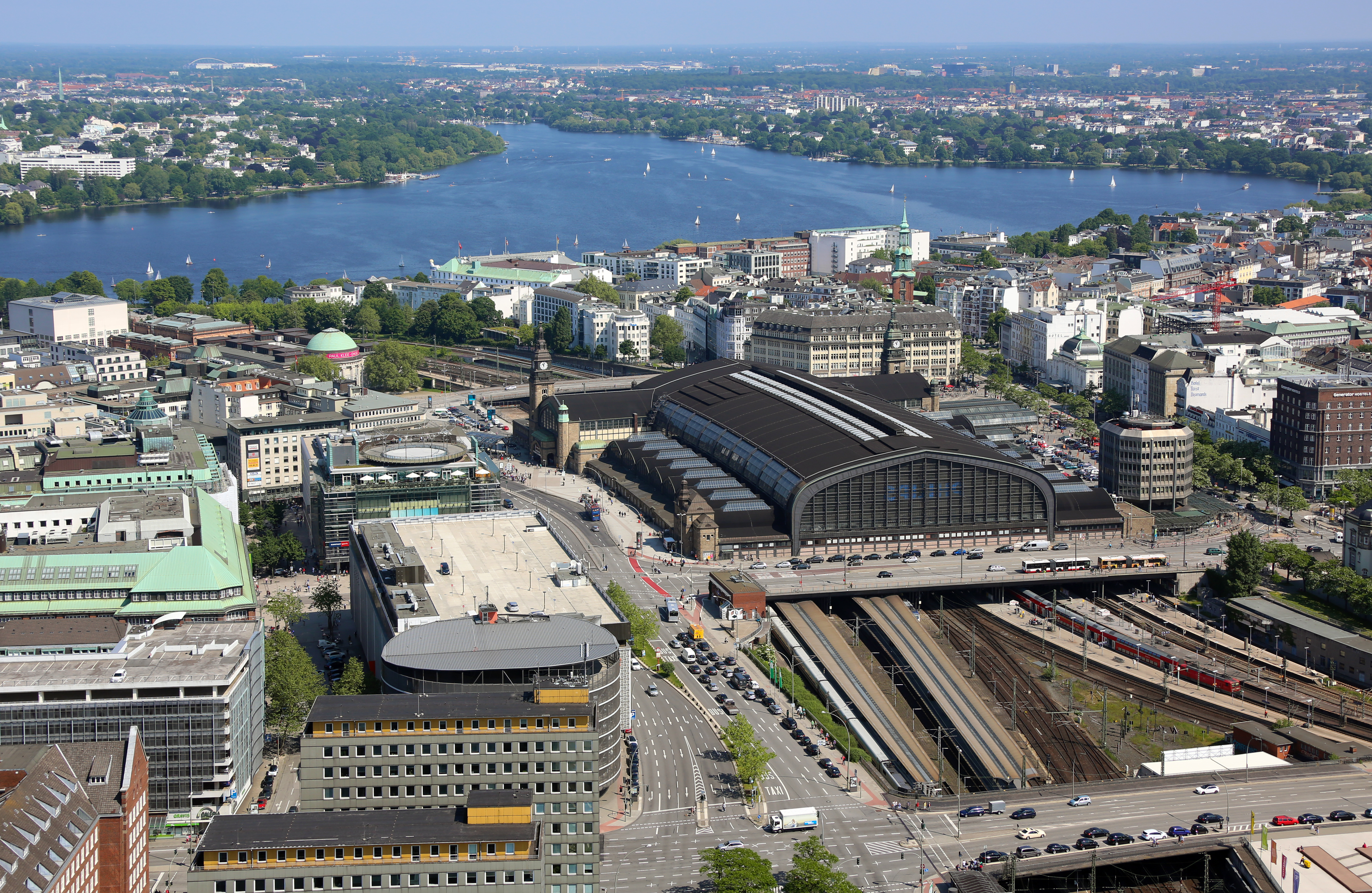
Deutsch: Luftblick auf den Bereich Hamburg Mitte mit dem Hamburger Hauptbahnhof, sowie dahinter der Außenalster.
This is a photograph of an architectural monument. It is on the list of cultural monuments of Hamburg, no. 899. English: Aerial view of Hamburg-Mitte with the Hamburg Hauptbahnhof (main railway station for the German city of Hamburg) and lake Außenalster.
|
| Date | |
| Source | Own work |
| Author | Alchemist-hp (talk) |
| Other versions | Derivative works of this file: 2013-06-08 Highflyer HP L4729 cropped.jpg |
| Camera location | | View this and other nearby images on: OpenStreetMap |
|---|

|
This photo was taken by Alchemist-hp. If you use one of my photos, an email (account needed) or a message or direct to: my email account would be greatly appreciated. |
|
This file is copyrighted and has been released under a license which is incompatible with Facebook's licensing terms. It is not permitted to upload this file to Facebook. |
Assessment[edit]
|
Licensing[edit]
- You are free:
- to share – to copy, distribute and transmit the work
- to remix – to adapt the work
- Under the following conditions:
- attribution – You must give appropriate credit, provide a link to the license, and indicate if changes were made. You may do so in any reasonable manner, but not in any way that suggests the licensor endorses you or your use.
- share alike – If you remix, transform, or build upon the material, you must distribute your contributions under the same or compatible license as the original.
| Copyleft: This work of art is free; you can redistribute it and/or modify it according to terms of the Free Art License. You will find a specimen of this license on the Copyleft Attitude site as well as on other sites. |
.JPG) |
Projekt Heißluftballon
HighFlyer Hamburg Dieses Foto wurde am 08. Juni 2013 im Rahmen des „Projekts Heißluftballon“ erstellt. |
 |
| Camera location | | View this and other nearby images on: OpenStreetMap |
|---|
File history
Click on a date/time to view the file as it appeared at that time.
| Date/Time | Thumbnail | Dimensions | User | Comment | |
|---|---|---|---|---|---|
| current | 15:05, 16 May 2014 | | 5,647 × 3,676 (9.1 MB) | Alchemist-hp (talk | contribs) | rotated, small other corrections |
| 14:43, 27 June 2013 |  | 5,760 × 3,840 (11.12 MB) | Alchemist-hp (talk | contribs) |
You cannot overwrite this file.
File usage on Commons
The following 9 pages use this file:
- Hamburg Hauptbahnhof
- User:Graphium/Favorites
- User:Nordlicht8/Rail Germany/2013 June 21-30
- User talk:Alchemist-hp/Archive/2014
- Commons:Featured picture candidates/File:2013-06-08 Highflyer HP L4729.JPG
- Commons:Featured picture candidates/Log/May 2014
- Commons:Quality images/Subject/Architecture/Cityscapes/Archive
- Commons:Quality images candidates/Archives May 27 2014
- File:Hamburg Hauptbahnhof.jpg
File usage on other wikis
The following other wikis use this file:
- Usage on de.wikipedia.org
- Schienenverkehr in Hamburg
- Wikipedia:Exzellente Bilder/Technik und Verkehr
- Wikipedia:Fotowerkstatt/Archiv/2013/Juli
- Wikipedia:Kandidaten für exzellente Bilder/Archiv2014/4
- Datei:2013-06-08 Highflyer HP L4729.JPG
- Wikipedia:WikiProjekt Hamburg/Auszeichnungen
- Wikipedia:WikiProjekt Hamburg/Auszeichnungen/Liste
- Usage on en.wikipedia.org
- Usage on en.wikivoyage.org
- Usage on fa.wikipedia.org
- Usage on he.wikipedia.org
- Usage on he.wikivoyage.org
- Usage on ja.wikipedia.org
- Usage on nl.wikipedia.org
- Usage on tr.wikipedia.org
- Usage on zh.wikipedia.org