File:2010 Eruption at Mount Merapi, Indonesia.jpg
Jump to navigation
Jump to search

Size of this preview: 681 × 599 pixels. Other resolutions: 273 × 240 pixels | 545 × 480 pixels | 873 × 768 pixels | 1,164 × 1,024 pixels | 2,327 × 2,048 pixels | 2,770 × 2,438 pixels.
Original file (2,770 × 2,438 pixels, file size: 1.57 MB, MIME type: image/jpeg)
Captions
Captions
Add a one-line explanation of what this file represents
Summary[edit]
| Description |
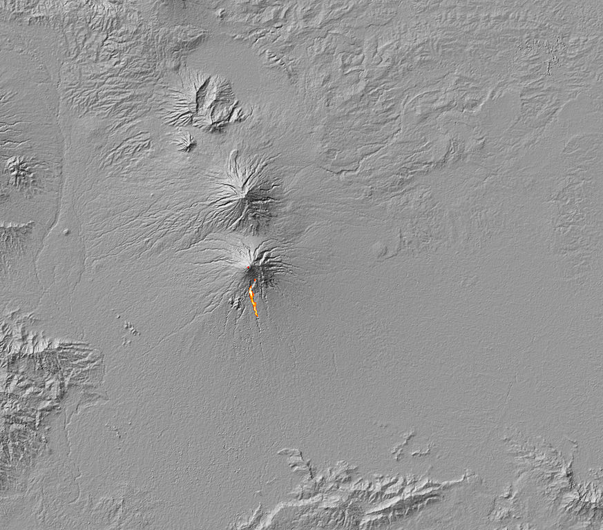
English: The thermal signature of hot ash and rock and a glowing lava dome on Mount Merapi. The thermal data is overlaid on a three-dimensional map of the volcano in this image to show the approximate location of the flow. The Center of Volcanology and Geological Hazard Mitigation reported that two pyroclastic flows moved down the volcano on October 30, 2010. A pyroclastic flow is an avalanche of extremely hot gas, ash, and rock that tears down the side of a volcano at high speeds. |
| Date | |
| Source | NASA Earth Observatory |
| Author | Robert Simmon and Jesse Allen |
Image captured by the Advanced Spaceborne Thermal Emission and Reflection Radiometer (ASTER) on NASA’s Terra satellite.
Licensing[edit]
| This file is in the public domain in the United States because it was solely created by NASA. NASA copyright policy states that "NASA material is not protected by copyright unless noted". (See Template:PD-USGov, NASA copyright policy page or JPL Image Use Policy.) | ||
 |
Warnings:
|
| Annotations | This image is annotated: View the annotations at Commons |
File history
Click on a date/time to view the file as it appeared at that time.
| Date/Time | Thumbnail | Dimensions | User | Comment | |
|---|---|---|---|---|---|
| current | 12:03, 5 November 2010 | | 2,770 × 2,438 (1.57 MB) | Originalwana (talk | contribs) | {{Information |Description={{en|1=The thermal signature of hot ash and rock and a glowing lava dome on Mount Merapi. The thermal data is overlaid on a three-dimensional map of the volcano in this image to show the approximate location of the flow. Th |
You cannot overwrite this file.
File usage on Commons
There are no pages that use this file.
File usage on other wikis
The following other wikis use this file:
- Usage on de.wikipedia.org
- Usage on en.wikipedia.org
- Usage on fr.wikipedia.org