File:2008 09L 5-day track.gif
Original file (895 × 716 pixels, file size: 37 KB, MIME type: image/gif)
Captions
Captions
Summary[edit]
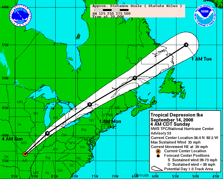
| Description |
Hurricane Ike 5-day tracking map from NHC. The mileage ruler is in statute miles, where 5 degrees of latitude span 345.2 miles (555.8 km),[1][2] and 5 degrees of longitude at 30 degrees North latitude span 299.8 miles (482.7 km).[3] The scale and offset of the map can vary with each advisory (compare map boundaries of advisories 43 & 44), re-centered for the latest forecast path (white cone). |
| Date | September 13, 2008 - 8AM CDT, Saturday |
| Source | http://www.nhc.noaa.gov/graphics_at4.shtml?5day#contents |
| Author | NHC/NOAA |
Licensing[edit]
This image is in the public domain because it contains materials that originally came from the U.S. National Oceanic and Atmospheric Administration, taken or made as part of an employee's official duties.
|
Distances for latitude or longitude[edit]
Measured in statue miles, 5 degrees of latitude span 345.2 miles (555.8 km), based on 1 degree as 69.05 statute miles (111.2 km), or 60 nautical miles. [1][2]
Longitude varies in length according to degree of latitude.[2] The following are a sampling of longitude lengths for selected latitudes, starting in the southern US and moving north:
- at 30 degrees North (area of Houston, Texas), a degree of longitude is 59.96 statute miles;[2]
- at 35 degrees North (area of Albuquerque, NM), a degree of longitude is 56.73 statute miles;
- at 40 degrees North (Kansas/Nebraska border), a degree of longitude is 53.06 statute miles;
- at 45 degrees North (Montana/Wyoming border), a degree of longitude is 49.00 statute miles.[2]
At 30 degrees North (near Houston), 5 degrees of longitude span 299.8 miles (555.8 km),[3] and at 35 north (near Albuquerque), 5 degrees of longitude span 283.65 (~284 miles, 457 km).[3]
Notes[edit]
- ↑ a b "Weights and Measures" (conversion tables), Upper New England Coast (UNEC) Cyber Community, 1999, webpage: UNEC.
- ↑ a b c d e "Latitude-Longitude Conversion to Feet", The Sentinel, February 2001, webpage: HyperNews-SAR-291 archive copy at the Wayback Machine.
- ↑ a b c For 30 degrees North, 5 degrees = 5 * 59.96 = 299.80 miles; for 35 degrees North, 5 degrees = 5 * 56.73 = 283.65 miles; based on the longitude conversion factors (see: References).
References[edit]
- "Latitude-Longitude Conversion to Feet", The Sentinel, February 2001, webpage: HyperNews-SAR-291 archive copy at the Wayback Machine.
File history
Click on a date/time to view the file as it appeared at that time.
| Date/Time | Thumbnail | Dimensions | User | Comment | |
|---|---|---|---|---|---|
| current | 14:14, 14 September 2008 | | 895 × 716 (37 KB) | DOSGuy (talk | contribs) | Advisory 53 |
| 03:04, 14 September 2008 |  | 895 × 716 (36 KB) | DOSGuy (talk | contribs) | Advisory 52 | |
| 15:05, 13 September 2008 |  | 895 × 716 (34 KB) | DOSGuy (talk | contribs) | Advisory 50 | |
| 14:44, 13 September 2008 |  | 895 × 716 (32 KB) | Prosfilaes (talk | contribs) | Advisory 49B | |
| 09:11, 13 September 2008 |  | 895 × 716 (33 KB) | TheTallOne~commonswiki (talk | contribs) | == Summary == {{Information |Description=Hurricane Ike 5-day tracking map from NHC. The mileage ruler is in statute miles, where 5 degrees of latitude span 345.2 miles (555.8 km),<ref name=WMeas/><ref name=LLconv/> and 5 degree | |
| 01:42, 13 September 2008 |  | 895 × 716 (28 KB) | Smichae (talk | contribs) | Advisory 47B | |
| 23:57, 12 September 2008 |  | 895 × 716 (28 KB) | Prosfilaes (talk | contribs) | {{Information |Description= |Source= |Date= |Author= |Permission= |other_versions= }} | |
| 20:14, 12 September 2008 |  | 895 × 716 (26 KB) | Smichae (talk | contribs) | Advisory 46A | |
| 15:29, 12 September 2008 |  | 895 × 716 (26 KB) | MarsInSVG (talk | contribs) | {{Information |Description=Hurricane Ike 5-day tracking map from NHC. The mileage ruler is in statute miles, where 5 degrees of latitude span 345.2 miles (555.8 km),<ref name=WMeas/><ref name=LLconv/> and 5 degrees of longitude | |
| 09:04, 12 September 2008 |  | 895 × 716 (34 KB) | Keith Edkins (talk | contribs) | Advisory 45 |
You cannot overwrite this file.
File usage on Commons
There are no pages that use this file.
File usage on other wikis
The following other wikis use this file:
- Usage on ar.wikipedia.org
- Usage on en.wikipedia.org
- Usage on nl.wikipedia.org
- Usage on pl.wikipedia.org
- Usage on sv.wikipedia.org
- Usage on ta.wikipedia.org