File:20080515215DR Dresden Waldschlösschen Graf Marcolini.jpg
Jump to navigation
Jump to search

Size of this preview: 398 × 599 pixels. Other resolutions: 159 × 240 pixels | 319 × 480 pixels | 510 × 768 pixels | 680 × 1,024 pixels | 1,682 × 2,531 pixels.
Original file (1,682 × 2,531 pixels, file size: 3.41 MB, MIME type: image/jpeg)
Captions
Captions
Add a one-line explanation of what this file represents
Summary[edit]
| Description |
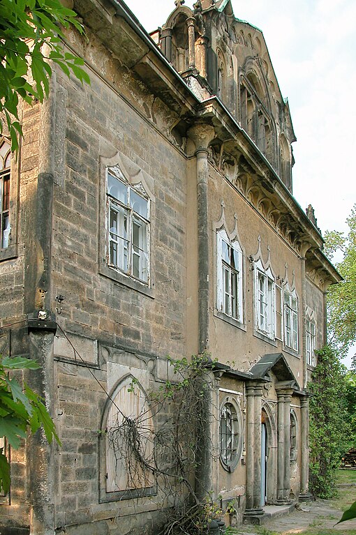
Deutsch: 15.05.2008 01099 Dresden-Radeberger Vorstadt, Radeberger Straße 60 (GMP: 51.069956,13.778287): Villa Marcolini, Südseite. Das Waldschlösschen ließ Graf Camillo
Marcolini (1739-1814) für seine irische Gemahlin Maria Anne O´Kelly 1785 - 1790 (evtl. 10 Jahre älter) vom Baumeister Johann Daniel Schade als Jagdschloß errichten. Vorbild soll ein Schloß in Großbritanien gewesen sein. Auffällig sind die gotischen Fensterformen. Über der Haustür prangt das Wappen des Grafen Marcolini. Das Haus gilt als erstes neugotisches Gebäude in Sachsen. Bis 1860 war es das einzige Haus auf Radeberger Straße. Man hatte einen wunderbaren Ausblick auf die Stadt und die Elbhänge. Jetzt ist die Sicht durch die Bebauung des Waldschlößchenareals versperrt. Nach dem Tode Marcolinis (1814) wurde das Gebäude versteigert. Ab 1829 wurde im Jagdschloß eine Schankwirtschaft betrieben. Zwischen 1945 und 1992 soll das Haus bewohnt gewesen sein. Derzeit [Anf. 2008] sieht Haus und Grundstück desolat aus. Nach der Wende wurde das Haus 1990 von der Bayerischen Hausbau erworben und weiterverkauft. Am 02.06.2009 wurde das Waldschlösschen für 214000 Euro versteigert. Erworben hat es der Psychologe und Geschäftsführer der "Klinik am Waldschlößchen" Klaus Dilcher. Er will das kleine Schloss nach der Sanierung nicht bewohnen, sondern stellt sich vielmehr eine Nutzung im Zusammenhang mit seiner Klinik zur Behandlung von psychisch traumatisierten Patienten nach Gewalt- oder Unfallerfahrungen vor. Die Umbauplaungen erstellte Architekt Jörg Möser. Denkmal. [DSCN32803.TIF]20080515215DR.JPG(c)Blobelt |
||||||||||||||
| Date | |||||||||||||||
| Source | Own work | ||||||||||||||
| Author |
|
||||||||||||||

| Object location | | View this and other nearby images on: OpenStreetMap |
|---|
Licensing[edit]
This file is licensed under the Creative Commons Attribution-Share Alike 4.0 International license.
- You are free:
- to share – to copy, distribute and transmit the work
- to remix – to adapt the work
- Under the following conditions:
- attribution – You must give appropriate credit, provide a link to the license, and indicate if changes were made. You may do so in any reasonable manner, but not in any way that suggests the licensor endorses you or your use.
- share alike – If you remix, transform, or build upon the material, you must distribute your contributions under the same or compatible license as the original.
File history
Click on a date/time to view the file as it appeared at that time.
| Date/Time | Thumbnail | Dimensions | User | Comment | |
|---|---|---|---|---|---|
| current | 19:17, 1 June 2023 | | 1,682 × 2,531 (3.41 MB) | Jörg Blobelt (talk | contribs) | Uploaded a work by {{Creator:Jörg Blobelt}} from {{own}} with UploadWizard |
You cannot overwrite this file.
File usage on Commons
The following 3 pages use this file: