File:2007 Organic Farm Acreage as a Percentage of State Area.svg

Original file (SVG file, nominally 959 × 593 pixels, file size: 90 KB)
Captions
Captions
| Description |
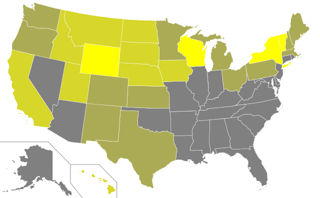
A map of the United States showing organic farm acreage as a percentage of state area in 2007.
Data: State Area in Square Miles1 Area in Acres2 Organic Farm Acreage3 Percent of State Area Occupied by Organic Farms Vermont 9,249.56 5919718.4 77509 1.31% National 3537377.04 2263921306 4077337 0.001801007 Notes: |
|
| Date | (UTC) | |
| Source | ||
| Author |
|
| This file is licensed under the Creative Commons Attribution-Share Alike 3.0 Unported license. | ||
| ||
| This licensing tag was added to this file as part of the GFDL licensing update. |

|
Permission is granted to copy, distribute and/or modify this document under the terms of the GNU Free Documentation License, Version 1.2 or any later version published by the Free Software Foundation; with no Invariant Sections, no Front-Cover Texts, and no Back-Cover Texts. A copy of the license is included in the section entitled GNU Free Documentation License. |
Original upload log[edit]
This image is a derivative work of the following images:
- File:Blank_US_Map.svg licensed with Cc-by-sa-3.0-migrated, GFDL
- 2009-11-05T19:44:02Z NuclearVacuum 959x593 (91518 Bytes) minor fix from previous upload
- 2009-11-05T19:39:42Z NuclearVacuum 959x593 (88399 Bytes) Fixed up the borders so they are connected with each state and loosing that gap between them.
- 2008-10-09T16:36:40Z Howcheng 959x593 (80121 Bytes) Reverted to version as of 08:32, 14 June 2007
- 2008-03-12T00:20:02Z AMK1211 959x593 (174744 Bytes) Added borders: Light blue for water borders and black for land borders (international borders thicker).
- 2007-06-14T08:32:47Z Fibonacci 959x593 (80121 Bytes) Optimised code.
- 2006-07-12T23:00:30Z Theshibboleth 959x593 (90537 Bytes) The line framework around Alaska and Hawaii has been pushed a bit
- 2006-07-12T06:35:19Z Theshibboleth 959x593 (89828 Bytes) added DC
- 2006-07-12T06:05:05Z Theshibboleth 959x593 (89649 Bytes) {{Information |Description=A blank map of the United States in scalable vector form. |Source=Own work, based on [[:Image:Electorial map.svg]], inspired by [[:Image:BlankMap-World.png]] |Date=11 July 2006 |Author=[[User:Theshi
Uploaded with derivativeFX
File history
Click on a date/time to view the file as it appeared at that time.
| Date/Time | Thumbnail | Dimensions | User | Comment | |
|---|---|---|---|---|---|
| current | 21:00, 19 February 2011 | | 959 × 593 (90 KB) | Ninjatacoshell (talk | contribs) | {{Information |Description=A map of the United States showing organic farm acreage as a percentage of state area in 2007.<br><br><table border="0" cellspacing="0" cellpadding="1" style="background:transparent"> <tr valign="top"><td> {{Legend|#808080|'''0% |
You cannot overwrite this file.
File usage on Commons
The following page uses this file: