File:1 Vitthala Vittala temple Vijayanagar Hampi Karnataka India April 2014.jpg
Original file (1,600 × 1,200 pixels, file size: 1.63 MB, MIME type: image/jpeg)
Captions
Captions
| Description |
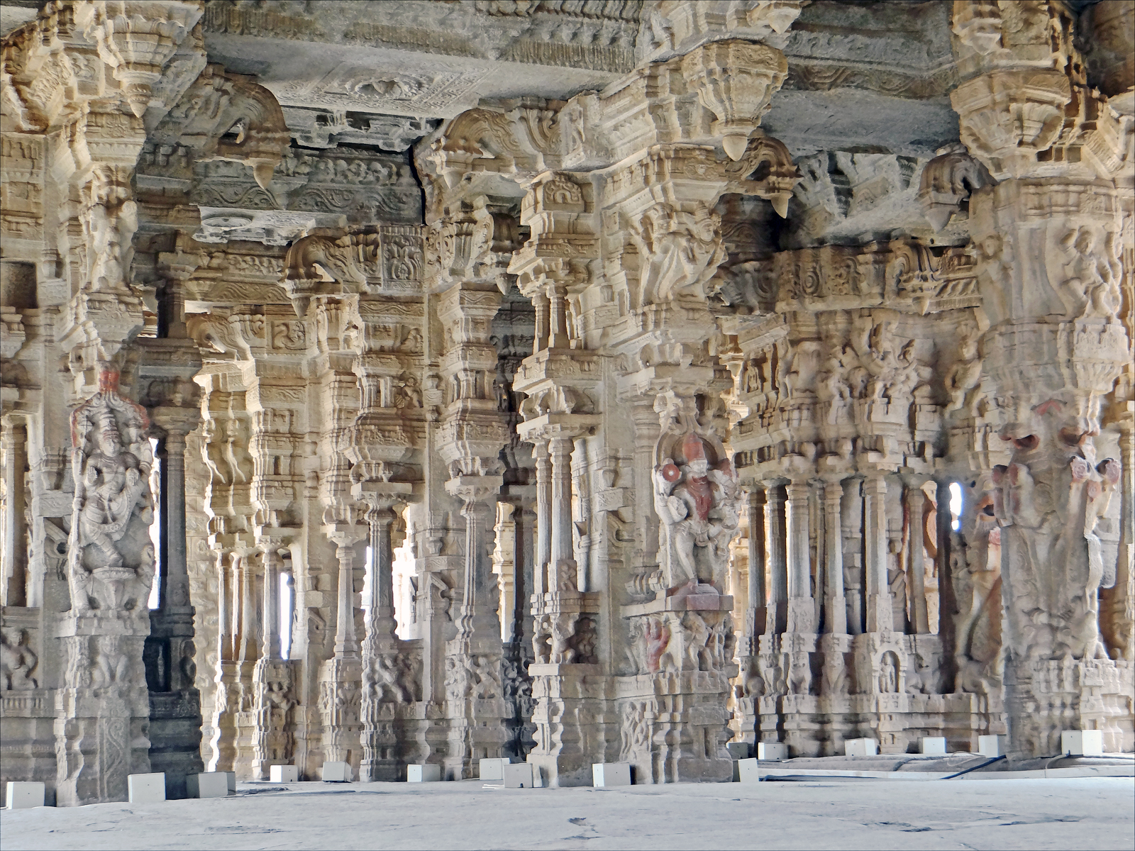
Vitthala or Vittala or Vithoba temple, is a Hindu temple, located in Hampi 350 km north of Bangalore, in the state of Karnataka in southern India. It is part of the Group of Hindu Monuments at Hampi. Vittala, after whom the temple is known, is a form of lord Vishnu. This avatar of Vishnu is revered as the protector of the cattle herds. The temple was built in the 15th century AD. It and the town around it was razed and damaged by Islamic army in 16th century, and one can visit the remains of a township called Vittalapura that existed around this temple complex. The highlight of Vittala temple is its impressive pillared halls and the stone chariot. The halls are carved with an array of sculptures on the giant granite pillars. The stone chariot located inside is an iconic structure of Hampi, and the symbol of Karnataka Tourism. The damaged temple was restored and rebuilt, in original style, in recent centuries. La salle hypostyle du temple de Vitthala à Hampi (Vijayanagar). Vitthala ou Vithoba est à l'origine un dieu local protecteur du bétail, il a été assimilé à Krishna, un des avatars de Vishnou. Cette salle proche du temple principal, dédié à Vishnou, a été réalisée vers 1550. C'est l'une des dernières grandes réalisations du royaume de Vijayanagar avant sa destruction en 1565 par la coalition de cinq armées musulmanes des émirats du nord de l'Inde. Avec ses 56 piliers finement sculptés, ornés de colonnettes et un plafond richement décoré, cette salle est considérée comme l'un des chefs-d'oeuvre de l'art de Vijayanagar, dont le style est imprégné des traditions artistiques de toute l'Inde du sud. |
||
| Date | |||
| Source | Flickr: Le temple de Vitthala (Hampi, Inde) | ||
| Author | Jean-Pierre Dalbéra | ||
| Permission (Reusing this file) |
This file is licensed under the Creative Commons Attribution 2.0 Generic license.
|
| Camera location | | View this and other nearby images on: OpenStreetMap |
|---|
File history
Click on a date/time to view the file as it appeared at that time.
| Date/Time | Thumbnail | Dimensions | User | Comment | |
|---|---|---|---|---|---|
| current | 23:21, 3 June 2014 | | 1,600 × 1,200 (1.63 MB) | Flickr upload bot (talk | contribs) | Uploaded from http://flickr.com/photo/72746018@N00/14266093011 using Flickr upload bot |
You cannot overwrite this file.
File usage on Commons
There are no pages that use this file.