File:1 IÖR-Monitor Anteil Verkehrsfläche an Gebietsfläche 2015 Raster 1000 m .png
Jump to navigation
Jump to search

Size of this preview: 536 × 600 pixels. Other resolutions: 214 × 240 pixels | 429 × 480 pixels | 686 × 768 pixels | 915 × 1,024 pixels | 1,561 × 1,747 pixels.
Original file (1,561 × 1,747 pixels, file size: 422 KB, MIME type: image/png)
Captions
Captions
Add a one-line explanation of what this file represents
Summary[edit]
| Description |
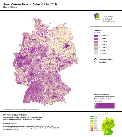
Deutsch: In den Karten des IÖR-Monitor ist der Anteil der Verkehrsfläche an der Gebietsfläche in Deutschland anschaulich dargestellt. |
| Date | |
| Source | IÖR-Monitor: Rasterkarte zum Anteil der Verkehrsfläche an der Gebietsfläche, Stand 2015: http://maps.ioer.de/detailviewer/raster/?rid=368 |
| Author | Leibniz-Institut für ökologische Raumentwicklung, Forschungsbereich Monitoring der Siedlungs- und, Freiraumentwicklung Dr. Gotthard Meinel, Weberplatz 1, 01217 Dresden |
Licensing[edit]
I, the copyright holder of this work, hereby publish it under the following license:
This file is licensed under the Creative Commons Attribution-Share Alike 4.0 International license.
- You are free:
- to share – to copy, distribute and transmit the work
- to remix – to adapt the work
- Under the following conditions:
- attribution – You must give appropriate credit, provide a link to the license, and indicate if changes were made. You may do so in any reasonable manner, but not in any way that suggests the licensor endorses you or your use.
- share alike – If you remix, transform, or build upon the material, you must distribute your contributions under the same or compatible license as the original.
File history
Click on a date/time to view the file as it appeared at that time.
| Date/Time | Thumbnail | Dimensions | User | Comment | |
|---|---|---|---|---|---|
| current | 11:14, 10 October 2016 | | 1,561 × 1,747 (422 KB) | Diversitas (talk | contribs) | Bild zurecht geschnitten |
| 08:16, 10 October 2016 |  | 1,563 × 2,199 (429 KB) | Diversitas (talk | contribs) | {{Information |Description ={{de|1=In den Karten des IÖR-Monitor ist der Anteil der Verkehrsfläche an der Gebietsfläche in Deutschland anschaulich nachzuvollziehen.}} |Source =IÖR-Monito... |
You cannot overwrite this file.
File usage on Commons
There are no pages that use this file.
File usage on other wikis
The following other wikis use this file:
- Usage on de.wikipedia.org